Section I
1. Critically examine plate tectonics and explain its relation to the evolution of major landform features on the surface of the earth.
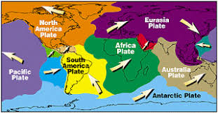
Ans: Plate tectonics is the scientific theory that explains the movement of the Earth’s lithosphere (the outermost layer of the Earth) in relation to the underlying asthenosphere. This theory states that the lithosphere is divided into a series of plates that move relative to one another, causing geological phenomena such as earthquakes, volcanic activity, and the formation of mountain ranges and ocean basins.
The theory of plate tectonics has been extensively researched and widely accepted by the scientific community since it was first proposed in the 1960s. It has provided a framework for understanding the formation and movement of the Earth’s crust, and it has been instrumental in explaining the evolution of major landform features on the surface of the Earth.
The movement of the tectonic plates can cause a variety of geological features on the Earth’s surface. For example, when two plates move towards each other, one plate may be forced under the other in a process called subduction. This can result in the formation of mountain ranges, such as the Andes in South America and the Himalayas in Asia.
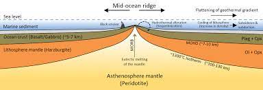
When plates move apart, new crust is formed at mid-ocean ridges, where magma rises to the surface and solidifies, creating a new oceanic crust. As this process continues, the newly formed crust moves away from the ridge and cools, creating a new ocean basin. The Mid-Atlantic Ridge is an example of a mid-ocean ridge, and the Atlantic Ocean is an example of an ocean basin that has formed in this way.
The movement of plates can also cause earthquakes and volcanic eruptions. Earthquakes occur when the plates move past each other or when one plate is forced under another. Volcanic eruptions can occur when magma rises to the surface at a subduction zone or at a mid-ocean ridge.
Plate tectonics has played a crucial role in the evolution of the Earth’s surface features. The movement of plates has led to the formation of continents, mountain ranges, and ocean basins. It has also influenced the distribution of flora and fauna by creating barriers and facilitating migrations.
Criticism
While plate tectonics is widely accepted among scientists, there are also some criticisms of the theory.
- Plate tectonics does not fully explain how the plates move.
- The theory has difficulty explaining some geological phenomena, such as the formation of certain types of mountain ranges or the movement of some smaller plates. Some small plates move inside the big Pacific plate, this is not feasible.
- There are some areas, such as the African continent, where plate tectonics does not seem to apply in the same way as it does in other parts of the world.
- Some scientists argue that plate tectonics cannot fully explain the patterns of distribution of certain minerals and geological formations.
- Plate tectonics may not fully explain the formation of some geological features, such as the Hawaiian Islands, which appear to have formed from a mantle plume rather than from plate tectonics.
In conclusion, plate tectonics is a scientific theory that explains the movement of the Earth’s lithosphere and the resulting geological phenomena. It has been instrumental in explaining the evolution of major landform features on the Earth’s surface, such as mountain ranges and ocean basins, and has provided a framework for understanding the distribution of flora and fauna.
2. (a) Examine the concept of air masses and fronts. Explain how far fronts contribute to the formation of cyclones.
Ans: Air Masses: Air masses are large bodies of air that have relatively uniform temperature and moisture characteristics. They cover vast regions and can extend horizontally for hundreds or thousands of kilometers. Air masses are typically classified based on their temperature and moisture content, which are influenced by the source region over which they form.
1. Source Regions: Air masses form over source regions, which are large areas with relatively uniform surface characteristics. These regions can be continental (land) or maritime (ocean) and can be located in tropical, polar, or arctic regions. The characteristics of the source region determine the temperature and moisture content of the resulting air mass.
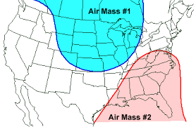
2. Temperature Classification: Air masses are classified based on their temperature characteristics. The two primary temperature classifications are:
Tropical (T): Air masses that form in the low-latitude regions and are warm.
Polar (P): Air masses that form in high-latitude regions and are cold.
Additionally, there can be Arctic (A) air masses, which are extremely cold and originate in the Arctic region.
3. Moisture Classification: Air masses are also classified based on their moisture content. The two primary moisture classifications are:
a. Maritime (m): Air masses that form over oceans and are moist. b. Continental (c): Air masses that form over land and are dry.
Combining the temperature and moisture classifications results in various air mass types. For example, a warm and moist air mass would be classified as a maritime tropical (mT) air mass.
Fronts: Fronts are boundaries between air masses with different temperature, humidity, and/or density characteristics. They are the primary features responsible for the development of weather systems and the associated changes in weather conditions. Fronts can be classified into several types based on the movement and characteristics of the air masses involved:
- Cold Front: A cold front occurs when a colder air mass advances and replaces a warmer air mass. As the cold air displaces the warm air, it lifts the warm air rapidly, leading to the formation of cumulonimbus clouds and the potential for heavy precipitation. Cold fronts are often associated with abrupt weather changes, including thunderstorms, strong winds, and a drop in temperature.
- Warm Front: A warm front occurs when a warmer air mass advances and replaces a colder air mass. The warm air gradually lifts the cooler air ahead of it, leading to the formation of stratiform clouds. Warm fronts typically bring more gradual weather changes, characterized by overcast skies, light-to-moderate precipitation, and a gradual increase in temperature.
- Stationary Front: A stationary front forms when the boundary between two air masses remains relatively stationary, with neither air mass displacing the other. This often results in a prolonged period of cloudiness and precipitation along the front.
- Occluded Front: An occluded front occurs when a fast-moving cold front overtakes a warm front, lifting the warm air mass off the ground. This complex frontal system can result in a mix of weather conditions, including precipitation and changes in wind direction.
- Dryline: A dryline is a boundary separating a warm, moist air mass from a hot, dry air mass. It is commonly found in the central United States, particularly during the spring and summer. Drylines can trigger the development of severe thunderstorms due to the contrasting air masses and associated instability.
Fronts play a crucial role in the formation and movement of weather systems, and their interaction can lead to the development of various weather phenomena, such as thunderstorms, hurricanes, and cyclones. Meteorologists analyze fronts to forecast weather patterns and understand the atmospheric dynamics associated with different air masses.
How fronts contribute to the formation of cyclones?
- Convergence of Air Masses: When a warm air mass and a cold air mass meet along a front, they have different densities and temperatures. The warm air is less dense and tends to rise, while the cold air is denser and sinks. This creates a convergence zone where the two air masses collide. The convergence of air results in the uplift of warm air along the front.
- Uplift and Instability: As the warm air rises along the front, it undergoes adiabatic cooling, which leads to the condensation of moisture and the formation of clouds. The uplift of warm air and the associated release of latent heat provide the necessary energy for the development of cyclones. The rising air further enhances instability in the atmosphere.
- Vertical Wind Shear: Along the front, there is often a significant change in wind speed and direction with height, known as vertical wind shear. Wind shear provides the necessary conditions for the development of rotation within the cyclone. The contrasting wind patterns between the warm and cold air masses can create a cyclonic circulation, with winds rotating counterclockwise in the Northern Hemisphere and clockwise in the Southern Hemisphere.
- Cyclogenesis: The convergence of air, uplift, and the presence of wind shear create favorable conditions for the development of a surface low-pressure system, or a cyclone. The low-pressure system intensifies as air continues to rise and converge, drawing in more moisture and energy from the surrounding environment. This process is known as cyclogenesis.
- Frontal Lifting and Occlusion: As the cyclone matures, the cold front associated with the advancing cold air mass catches up with the warm front. This process is called occlusion. The occlusion causes the warm air to be lifted rapidly, resulting in the formation of more intense precipitation and storm activity. The occluded front wraps around the cyclone’s center, often resembling a spiral shape.
It’s important to note that cyclones can form through various mechanisms, including tropical cyclones that develop over warm ocean waters. However, the interaction of air masses along fronts, particularly in mid-latitude regions, contributes significantly to the formation and intensification of cyclones in those areas. Meteorologists closely monitor the dynamics of fronts and the associated air mass interactions to forecast the development and movement of cyclones.
Explain the main sources of ocean deposits and their vertical distribution on the ocean floor.
Discuss the factors involved in soil formation and their role in the global distribution of soils
Explain the salient ecological features of the monsoon forest biome
Critically compare quantitative and behavioural revolutions in geography and examine their role in the development of the subject
What is demographic transition? How had it affected the world population distribution?
Discuss the factors that govern the internal structure of cities
What is the difference between the concepts of heartland and rimland?
Explain, in brief, the contemporary pattern of world trade
Give a brief account of the distribution of soils in India
Examine the population problems of India along with their spatial variations
Discuss the major ecological problems in India and examine the efficacy of the measures taken for their solution
Explain the relationship between irrigation and cropping intensity in India
Discuss the factors governing the location of agro-based industries in India
Explain the role of market centres in promoting rural development in India
Explain urban development problems in Bihar and suggest measures to overcome the same
Bring out the geopolitical significance of the Indian ocean area
Discuss the regional development issues in Bihar and suggest measures to improve the situation
Bring out the pattern of agriculture in Bihar and discuss the factors responsible for such a pattern