Applied Geomorphology is the application of the principles and theories of geomorphology to real-world problems and challenges. It is an interdisciplinary field that integrates the knowledge and expertise of geomorphologists, engineers, hydrologists, and other professionals to address practical issues related to the Earth’s surface.
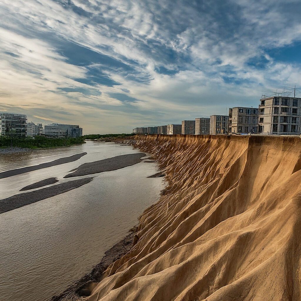
Table of Contents
What is Applied Geomorphology?
Applied geomorphology is a branch of geology that focuses on the practical applications of geomorphological knowledge and principles to address real-world problems and challenges. It involves the study of landforms, their origins, and the processes that shape them, with the aim of understanding and managing landscapes to mitigate natural hazards, conserve natural resources, and support sustainable development.
In applied geomorphology, researchers and practitioners utilize various techniques and methodologies to analyze landscapes and assess their vulnerability to natural hazards such as landslides, floods, erosion, and earthquakes. By understanding the underlying geological processes that contribute to these hazards, scientists can develop strategies for hazard assessment, risk mitigation, and disaster management.
Furthermore, applied geomorphology plays a crucial role in land-use planning, environmental management, and engineering projects. Geomorphological studies provide valuable insights into soil erosion, sedimentation patterns, watershed management, and the impacts of human activities on landscapes. This information is essential for designing infrastructure, such as roads, bridges, dams, and urban developments, that are resilient to natural processes and minimize environmental impacts.
Applications of Applied Geomorphology
Environmental management and conservation: Geomorphologists use their understanding of the Earth’s surface and landscape processes to help manage and conserve natural resources, such as water and soil, and to mitigate the impact of human activities on the environment.
Natural hazards: Geomorphologists study the processes that contribute to natural hazards such as landslides, floods, and earthquakes, and use their knowledge to predict and manage these hazards and minimize their impacts on communities.
Infrastructure development: Geomorphologists work with engineers and planners to assess the impact of infrastructure development projects, such as highways and buildings, on the Earth’s surface and to minimize the potential for damage or disruption to the environment.
Urban planning: Geomorphologists work with urban planners and developers to understand the impact of urbanization on the Earth’s surface and to design sustainable, environmentally-friendly cities. The study helps to understand the type of infrastructure best suitable for a region.
Resource extraction: Geomorphologists collaborate with resource extraction industries, such as mining and oil and gas, to minimize the impact of resource extraction activities on the environment and to ensure that resources are extracted in a sustainable manner.
Methods to Study
Applied geomorphologists use a range of methods to study the Earth’s surface and understand the processes that shape it. These methods include:
Field observations and mapping: Geomorphologists use a range of field techniques, such as mapping, aerial photography, and remote sensing, to study the landforms and processes that shape the Earth’s surface.
Laboratory analysis: Geomorphologists use laboratory analysis to study the physical and chemical properties of soils, rocks, and other materials that make up the Earth’s surface.
Computer modeling: Geomorphologists use computer models to simulate the processes that shape the Earth’s surface, such as erosion, deposition, and tectonic uplift.
Statistical analysis: Geomorphologists use statistical analysis to study the relationships between different landforms and processes, such as the relationship between stream flow and topography.
Applied geomorphology is a dynamic and rapidly evolving field that plays a critical role in addressing real-world problems and challenges related to the Earth’s surface. By integrating the knowledge and expertise of multiple disciplines, applied geomorphologists are helping to ensure the sustainable use and management of the Earth’s resources and the protection of the environment.
Read: Geography