Burgess and Hoyt were urban sociologists who proposed models to describe the internal structure of cities based on the spatial distribution of different land uses. These models were developed primarily to explain the patterns of land use and residential zones within growing cities.
Burgess’s Concentric Zone Model:
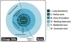
Ernest Burgess proposed the Concentric Zone Model in 1925 to explain the growth and organization of cities in concentric rings, radiating outward from the central business district (CBD). The model consists of five zones:
- CBD (Central Business District): The central hub of economic and commercial activity, typically characterized by tall buildings, offices, retail stores, and financial institutions.
- Zone of Transition: Surrounding the CBD, this area is marked by older housing, industry, and deteriorating infrastructure. It is often a mix of commercial, industrial, and residential uses, and it experiences high population density.
- Zone of Working-Class Homes: This zone consists of older residential areas, often in poor condition due to age and neglect. It is inhabited by working-class families and might have a mix of small businesses and industry.
- Zone of Better Residences: This area contains better-maintained housing, occupied by middle-class families. It has lower population density compared to the previous zones and is characterized by single-family homes.
- Commuter Zone: The outermost ring comprises suburbs and commuter towns. It’s characterized by spacious housing, lower population density, and residents who commute to the CBD for work.
Hoyt’s Sector Model:
Homer Hoyt proposed the Sector Model in 1939, which emphasizes the role of transportation routes in shaping the city’s growth. It suggests that certain sectors of the city develop more rapidly than others due to the presence of transportation corridors. The model includes the following sectors:
- CBD: Similar to Burgess’s model, the central business district serves as the core of economic activity.
- Transportation/Industrial Sector: This sector extends along transportation routes like roads, railways, or rivers. It contains factories, warehouses, and other industrial facilities.
- Low-Class Residential Sector: Residential areas develop adjacent to industrial zones, often inhabited by low-income groups. These areas experience pollution and noise from nearby industries.
- Middle-Class Residential Sector: More affluent residents settle in sectors farther from industrial areas. The housing quality is better, and these areas often have parks and amenities.
- High-Class Residential Sector: The outermost sector is occupied by higher-income groups, usually situated on elevated ground with better views and cleaner air.
Limitations of These Models:
- Simplification: Both models oversimplify the complex and dynamic nature of urban growth and land use patterns. Real cities exhibit more diverse and irregular spatial arrangements.
- Assumption of Homogeneity: The models assume that all areas within a zone are homogenous, ignoring variations in income, ethnicity, and culture that often exist within the same zone.
- Neglect of Historical Factors: The models focus on contemporary factors and don’t consider historical or cultural influences on urban development.
- Changing Land Use Patterns: Urban development patterns have evolved over time, making these models less applicable to modern cities with diverse land uses and transportation networks.
- Neglect of Non-Residential Centers: Both models emphasize the CBD, often neglecting the presence of other important centers like cultural, educational, and recreational hubs.
While these models have limitations, they provided foundational insights into urban sociology and helped researchers understand the general patterns of urban growth and land use in certain contexts. Thanks for reading the article on Burgess and Hoyt Land Use Models.
Read: