Class 11 Geography NCERT Solutions Chapter 3 Interior of the Earth
“Interior of the Earth” is the third chapter of Class 11 Geography NCERT. We have prepared the Class 11 Geography NCERT Solutions Chapter 3 for your ready reference.
1. Multiple choice questions.
(i) Which one of the following earthquake waves is more destructive?
(a) P-waves (c) Surface waves
(b) S-waves (d) None of the above
Ans: (c) Surface waves
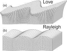
Explanation: Surface waves, also known as Love waves and Rayleigh waves, are more destructive than P-waves and S-waves. Surface waves cause the most damage during an earthquake as they move along the Earth’s surface and have a greater amplitude than body waves like P-waves and S-waves. They are responsible for the shaking and ground motion that often leads to structural damage.

(ii) Which one of the following is a direct source of information about the interior of the earth?
(a) Earthquake waves (c) Gravitational force
(b) Volcanoes (d) Earth magnetism
Ans: (b) Volcanoes
Explanation: Volcanoes offer insights into processes occurring in the Earth’s crust and upper mantle, and they can provide information about the movement of molten material (magma) beneath the surface. Hence, it is called a direct source of information.
(iii) Which type of volcanic eruptions have caused Deccan Trap formations?
(a) Shield (c) Composite
(b) Flood (d) Caldera
Ans: (b) Flood
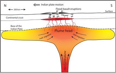
Explanation: The Deccan Traps are a vast volcanic plateau in western India that was formed by a series of massive flood basalt eruptions. These eruptions are commonly referred to as “flood basalt” eruptions. The term “trap” is derived from the Swedish word “trappa,” which means “stairs,” and it refers to the step-like topography that often results from the layering of successive lava flows during such eruptions.

(iv) Which one of the following describes the lithosphere:
(a) upper and lower mantle (c) crust and core
(b) crust and upper mantle (d) mantle and core
Ans: (b) crust and upper mantle
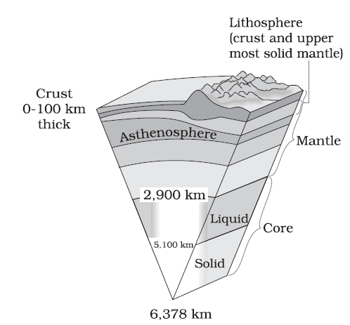
Explanation: The lithosphere is the rigid outermost layer of the Earth, and it consists of the crust and the uppermost part of the mantle. It is divided into tectonic plates that float on the semi-fluid asthenosphere beneath them. The lithosphere is responsible for the Earth’s tectonic activity, including the movement of continents, the formation of mountains, and the occurrence of earthquakes and volcanic eruptions.

2. Answer the following questions in about 30 words.
(i) What are body waves?
Ans: Body waves are seismic waves that travel through Earth’s interior. P-waves compress and expand particles in the direction of propagation, while S-waves move particles side-to-side. These waves provide insights into Earth’s composition and structure, aiding the study of its deep interior and seismic events.
(ii) Name the direct sources of information about the interior of the earth.
Ans: Direct sources of information about the Earth’s interior include:
- Seismic Waves from Earthquakes: These waves travel through the Earth, revealing details about its composition and layering. The study of how these waves propagate helps scientists map the Earth’s interior.
- Mining and Drilling: Deep mining operations and drilling into the Earth’s crust provide access to rock samples, which offer insights into the composition and characteristics of different layers.
- Volcanic Eruptions: Volcanic activity brings up molten material from the Earth’s mantle, providing information about the composition of the mantle and its interactions with the crust.
(iii) Why do earthquake waves develop shadow zone?
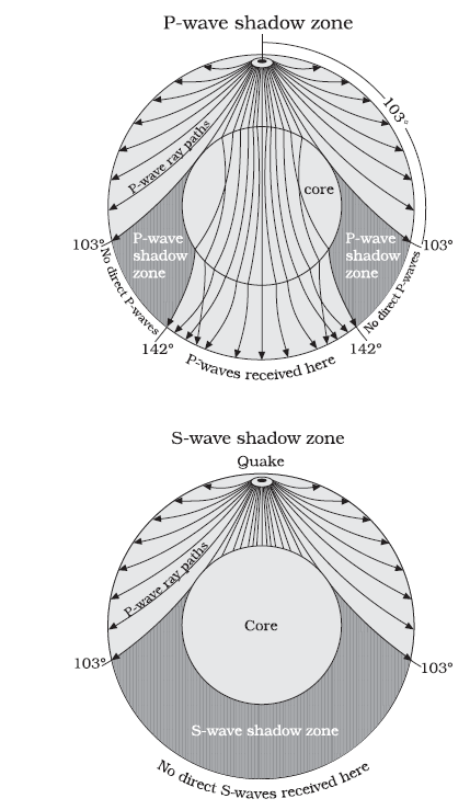
Ans: Earthquake waves develop shadow zones due to the refraction and reflection of waves as they pass through the Earth’s core. P-waves have a shadow zone between 103° and 143° due to refraction, while S-waves create a shadow zone between 103° and 180° because they can’t travel through the liquid outer core.

(iv) Briefly explain the indirect sources of information of the interior of the Earth other than those of seismic activity.
3. Answer the following questions in about 150 words.
(i) What are the effects of propagation of earthquake waves on the rock mass through which they travel?
Ans: The propagation of earthquake waves through rock masses can have several effects:
- Distortion and Displacement: Seismic waves cause rocks to vibrate and oscillate. P-waves compress and expand rock particles, while S-waves move particles side-to-side. This movement can lead to distortion and displacement of rock layers, potentially causing fractures and faults.
- Stress and Strain: Seismic waves generate stress within the rock mass, leading to strain and deformation. High-frequency waves can cause rocks to break or shatter, while low-frequency waves can induce gradual deformation over time.
- Cracking and Fracturing: The intense energy of seismic waves can create new cracks or widen existing fractures in rocks. This process is particularly prominent near fault zones, where stress concentrations are already present.
- Liquefaction: In areas with loose, water-saturated sediments, the shaking from seismic waves can cause the ground to temporarily behave like a liquid. This phenomenon, known as liquefaction, can lead to the sinking or tilting of buildings and structures.
(ii) What do you understand by intrusive forms? Briefly describe various intrusive forms.
Ans: Intrusive forms refer to igneous rock formations that have solidified beneath the Earth’s surface from molten magma. These formations are also known as plutonic rocks or intrusions. Intrusive rocks cool and crystallize slowly within the Earth’s crust, giving them a coarse-grained texture. They contrast with extrusive forms, such as volcanic rocks, which cool rapidly on the Earth’s surface.
- Batholiths: Batholiths are the largest intrusive formations, covering extensive areas of the Earth’s crust. These massive structures form when multiple plutons merge and solidify deep underground. Examples include the Sierra Nevada Batholith in California.
- Stocks: Stocks are smaller than batholiths but still represent significant plutonic intrusions. They have similar compositions to batholiths but cover smaller areas. A stock is essentially a smaller, isolated version of a batholith.
- Plutons: Plutons are individual masses of igneous rock formed from cooled magma chambers. They come in various shapes, including tabular, lenticular, or irregular. Dikes and sills are specific types of plutons.
- Dikes: Dikes are vertical or near-vertical intrusions of magma that cut across existing rock layers. They often form when magma is injected into fractures or faults in the crust and then cools and solidifies.
- Sills: Sills are horizontal or near-horizontal intrusions that occur between existing rock layers. Magma intrudes parallel to the layering of surrounding rocks. Sills can be found at various depths within the crust.
- Laccoliths: Laccoliths are lens-shaped intrusions that push overlying rock layers upward, creating a dome-like structure. These formations can be quite large and are often associated with domed landscapes.
- Bathyliths: Bathyliths are intermediate in size between stocks and batholiths. They have characteristics of both, with larger dimensions than stocks but not as extensive as batholiths.
- Phacoliths: Phacoliths are curved plutons formed when magma forces the overlying rock layers to bend or fold. They are typically concave upward and result from the deformation caused by the intrusion itself.
Intrusive forms provide valuable insights into the geologic history and processes occurring beneath the Earth’s surface. They often play a significant role in the creation of mountain ranges and the evolution of Earth’s crust over geological time.
Thanks for reading article on Class 11 Geography NCERT Solutions Chapter 3 Interior of the Earth.
Read
