Class 11 Geography NCERT Solutions Chapter 4 Distribution of Oceans and Continents
“Distribution of Oceans and Continents” is the fourth chapter of Class 11 Geography NCERT. We have prepared the Class 11 Geography NCERT Solutions Chapter 4 for your ready reference.
1. Multiple choice questions.
(i) Who amongst the following was the first to consider the possibility of Europe, Africa and America having been located side by side.
(a) Alfred Wegener (c) Abraham Ortelius
(b) Antonio Pellegrini (d) Edmond Hess
Ans: (c) Abraham Ortelius
Explanation: Abraham Ortelius, a Flemish cartographer and geographer, was the first to propose the idea of the continents of Europe, Africa, and America having been connected and located side by side. He suggested this concept in his work “Theatre of the World” published in 1570. However, his idea was not based on the theory of plate tectonics but was more of a speculative geographical hypothesis.
Alfred Wegener, a German meteorologist and geophysicist, later developed the theory of continental drift in the early 20th century, suggesting that the continents were once part of a single supercontinent and have since drifted apart. This theory laid the groundwork for the modern understanding of plate tectonics.
(ii) Polar fleeing force relates to:
(a) Revolution of the Earth (c) Rotation of the earth
(b) Gravitation (d) Tides
Ans: (c) Rotation of the earth
Explanation: The term “polar fleeing force” is used in the context of the Earth’s rotation. It refers to the centrifugal force exerted on objects at or near the equator due to the Earth’s rotation. This force is a result of the Earth’s equatorial bulge, where the equator is slightly farther from the center of the Earth compared to the poles. As the Earth rotates, objects at the equator experience this outward force.
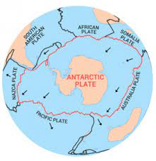
(iii) Which one of the following is not a minor plate?
(a) Nazca (c) Philippines
(b) Arabia (d) Antarctica
Ans: (d) Antarctica
Explanation: Among the options provided, Antarctica is not considered a minor tectonic plate. It is part of the larger Antarctic Plate. The other options—Nazca, Philippines, and Arabia—are examples of minor tectonic plates. Tectonic plates are large sections of the Earth’s lithosphere that move and interact with each other, leading to various geological phenomena such as earthquakes, volcanoes, and mountain formation.
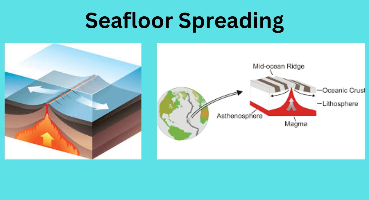
(iv) Which one of the following facts was not considered by those while discussing the concept of sea floor spreading?
(a) Volcanic activity along the mid-oceanic ridges.
(b) Stripes of normal and reverse magnetic field observed in rocks of ocean
floor.
(c) Distribution of fossils in different continents.
(d) Age of rocks from the ocean floor.
Ans: (c) Distribution of fossils in different continents.
Explanation: The concept of sea floor spreading primarily focused on evidence related to volcanic activity along mid-oceanic ridges, the alternating pattern of normal and reverse magnetic fields recorded in rocks of the ocean floor (magnetic striping), and the age of rocks from the ocean floor. While the distribution of fossils can provide information about past environments and life forms, it was not a central consideration in the development of the sea floor spreading theory. The other options directly relate to the evidence and observations that supported the idea of new oceanic crust forming at mid-ocean ridges and spreading away from them.
(v) Which one of the following is the type of plate boundary of the Indian plate along the Himalayan mountains?
(a) Ocean-continent convergence
(b) Divergent boundary
(c) Transform boundary
(d) Continent-continent convergence
Ans: (d) Continent-continent convergence
Explanation: The Indian plate converging with the Eurasian plate along the Himalayan mountains is an example of a continent-continent convergence boundary. In this type of plate boundary, two continental plates are colliding and pushing against each other. The intense compression and folding of the Earth’s crust at this boundary give rise to mountain ranges, such as the Himalayas, as well as seismic activity due to the tectonic forces involved.

2. Answer the following questions in about 30 words.
(i) What were the forces suggested by Wegener for the movement of the continents?
Ans: Alfred Wegener proposed the theory of continental drift to explain the movement of continents. He suggested that the continents were once part of a supercontinent called Pangaea and that they drifted apart over time. Wegener hypothesized the existence of several driving forces, although he did not provide a detailed mechanism for these forces. The forces he suggested included:
- Centrifugal Force: Wegener proposed that the Earth’s rotation could generate a centrifugal force that pushed the continents away from the equator. This force was thought to be responsible for the movement of the continents from a hypothetical original position near the South Pole.
- Tidal Forces: Wegener also considered tidal forces, arising from the gravitational interaction between the Moon and the Earth, as a possible driving mechanism. He suggested that the tidal forces might have played a role in the movement of the continents.
(ii) How are the convectional currents in the mantle initiated and maintained?
Ans: Convectional currents in the mantle are initiated and maintained by the heat generated from the Earth’s core and radioactive decay. As hotter, less dense material rises, and cooler, denser material sinks, a cyclical movement is established. This process, called mantle convection, drives the movement of tectonic plates and shapes Earth’s surface.
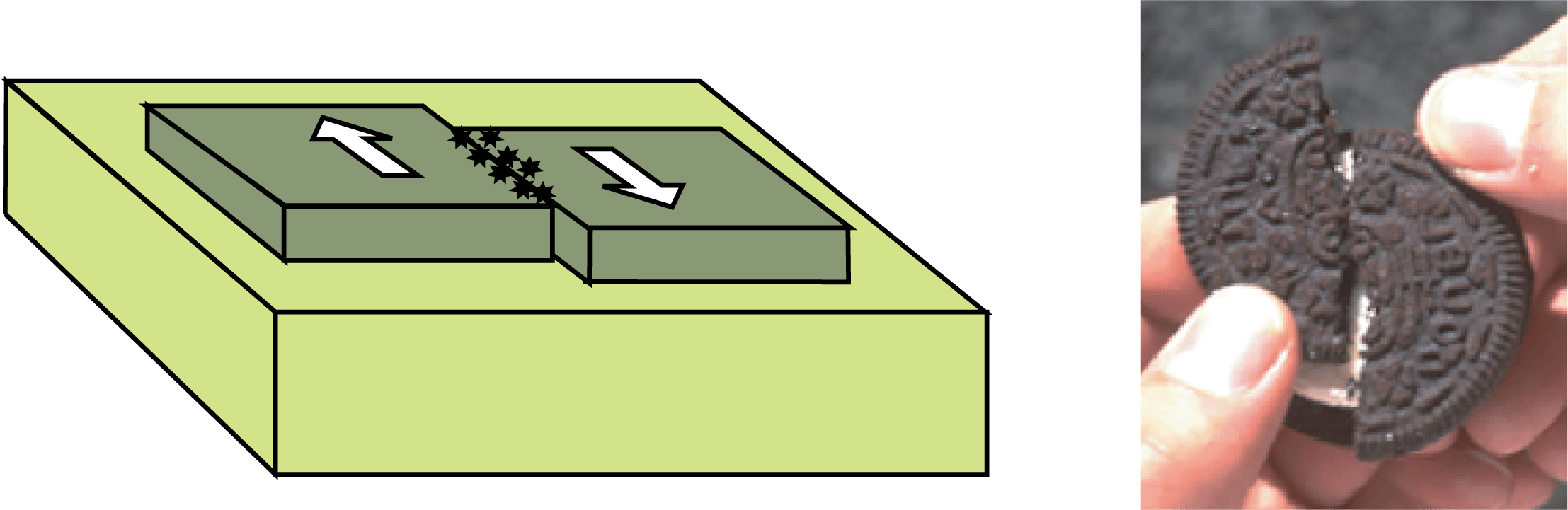
(iii) What is the major difference between the transform boundary and the convergent or divergent boundaries of plates?
Ans: The major difference lies in their interactions. Transform boundaries involve plates sliding past each other horizontally, causing earthquakes. Convergent boundaries lead to plates colliding, either subducting or forming mountains. Divergent boundaries occur when plates move apart, causing seafloor spreading and creating new crust.
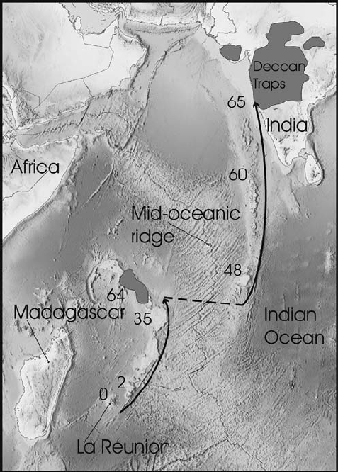
(iv) What was the location of the Indian landmass during the formation of the Deccan Traps?
Ans: During the formation of the Deccan Traps, the Indian landmass was situated in the vicinity of the present-day Indian Ocean, near the Reunion hotspot. The volcanic activity that created the Deccan Traps occurred as the Indian plate moved over this hotspot around 66 million years ago.
3. Answer the following questions in about 150 words.
(i) What are the evidences in support of the continental drift theory?
Ans: The continental drift theory, proposed by Alfred Wegener, suggests that Earth’s continents were once part of a single supercontinent called Pangaea and have since drifted apart. Several lines of evidence support this theory:
- Fit of Continents: The coastlines of continents, such as South America and Africa, appear to fit together like pieces of a jigsaw puzzle, implying they were once connected.
- Geological Similarities: Matching rock formations, mountain ranges, and geological structures across continents, such as the Appalachian Mountains in North America and Caledonian Mountains in Europe, provide evidence of past connections.
- Fossil Evidence: Identical or closely related fossils of plants and animals found on continents separated by oceans, such as the Mesosaurus in South America and Africa, suggest a common ancestral landmass.
- Climate Clues: Geological evidence, like glacial deposits and coal beds, suggests continents were once located in different climatic zones, supporting the idea of their movement.
- Paleomagnetic Data: Alternating patterns of normal and reversed magnetic fields recorded in oceanic crust match the spreading of the seafloor, confirming the concept of sea floor spreading.
- Distribution of Earthquakes and Volcanoes: Earthquakes and volcanic activity are concentrated along plate boundaries, supporting the idea of moving tectonic plates.
These evidences collectively contributed to the acceptance of plate tectonics, which explains the movement of continents via the interaction of rigid lithospheric plates floating on the semi-fluid asthenosphere beneath them.
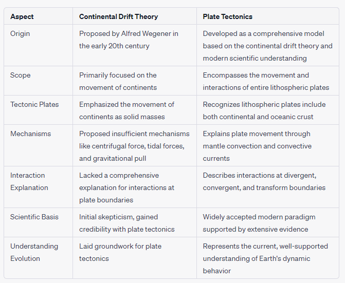
(ii) Bring about the basic difference between the drift theory and Plate tectonics.
Ans:
(iii) What were the major post-drift discoveries that rejuvenated the interest of scientists in the study of distribution of oceans and continents?
Ans: After the initial proposal of the continental drift theory by Alfred Wegener, several key discoveries and developments rejuvenated the interest of scientists in the study of the distribution of oceans and continents. These discoveries provided compelling evidence and a more comprehensive framework for understanding the movement of Earth’s lithospheric plates. Some of the major post-drift discoveries include:
- Seafloor Spreading: In the 1950s and 1960s, the exploration of the ocean floor using sonar and other technologies revealed the presence of mid-ocean ridges, underwater mountain ranges, and a system of interconnected rifts. The discovery of young oceanic crust near these ridges supported the idea of seafloor spreading, where new crust is continuously formed at mid-ocean ridges and spreads away from them.
- Magnetic Striping: Paleomagnetic studies in the 1960s showed alternating bands of normal and reversed magnetic polarity in rocks of the ocean floor. This magnetic striping on the seafloor provided strong evidence for seafloor spreading and the concept of magnetic pole reversals over geological time.
- Global Plate Boundaries: The identification of various types of plate boundaries—divergent, convergent, and transform—highlighted the dynamic interactions between tectonic plates. Earthquakes, volcanic activity, and other geologic phenomena were linked to these boundaries.
- Subduction Zones: The discovery of deep ocean trenches and the study of earthquake patterns revealed the process of subduction, where one tectonic plate is forced beneath another into the Earth’s mantle. This process provided an explanation for the disappearance of oceanic crust and the recycling of material within the Earth.
- Plate Tectonics Theory: The development of the plate tectonics theory in the 1960s and 1970s synthesized these discoveries into a comprehensive model. Plate tectonics explained how the movement of lithospheric plates drives geological processes such as earthquakes, volcanic activity, mountain formation, and the shaping of Earth’s surface.
- Geological and Fossil Correlations: Advances in paleontology and the study of rock formations allowed scientists to correlate geological features and fossil evidence across continents, providing additional support for the movement of continents.
These post-drift discoveries collectively led to the establishment of the modern theory of plate tectonics, revolutionizing our understanding of Earth’s dynamic processes and shaping the field of earth sciences.
Thanks for reading article on Class 11 Geography NCERT Solutions Chapter 4.
Project Work
Prepare a collage related to damages caused by an earthquake.
Ans:

Read
