Continental Drift is a theory that suggests the Earth’s continents were once joined together in a single supercontinent known as Pangaea and have since drifted apart over millions of years to their current positions. The theory was proposed by Alfred Wegener in the early 20th century, although it was initially met with skepticism before being widely accepted as a fundamental concept in the field of geology. It describes the large-scale movement of continents across the Earth’s surface over geological timescales.

Table of Contents
What is Continental Drift?
Continental drift was a theory proposed by Alfred Wegener in the early 20th century. He explained that the Earth’s continents were not fixed in place, but rather had moved significantly over vast amounts of geological time. Continental Drift is a foundational concept in geography and earth sciences, explaining the gradual movement of continents across Earth’s surface over geological time. This theory laid the groundwork for modern plate tectonics. Geographers analyze this phenomenon not just in terms of physical movement but also its implications for climate, ecosystems, and human settlements.
Evidence of Continental Drift
The evidence for continental drift is drawn from various spatial patterns and environmental indicators.
Fit of the Continents
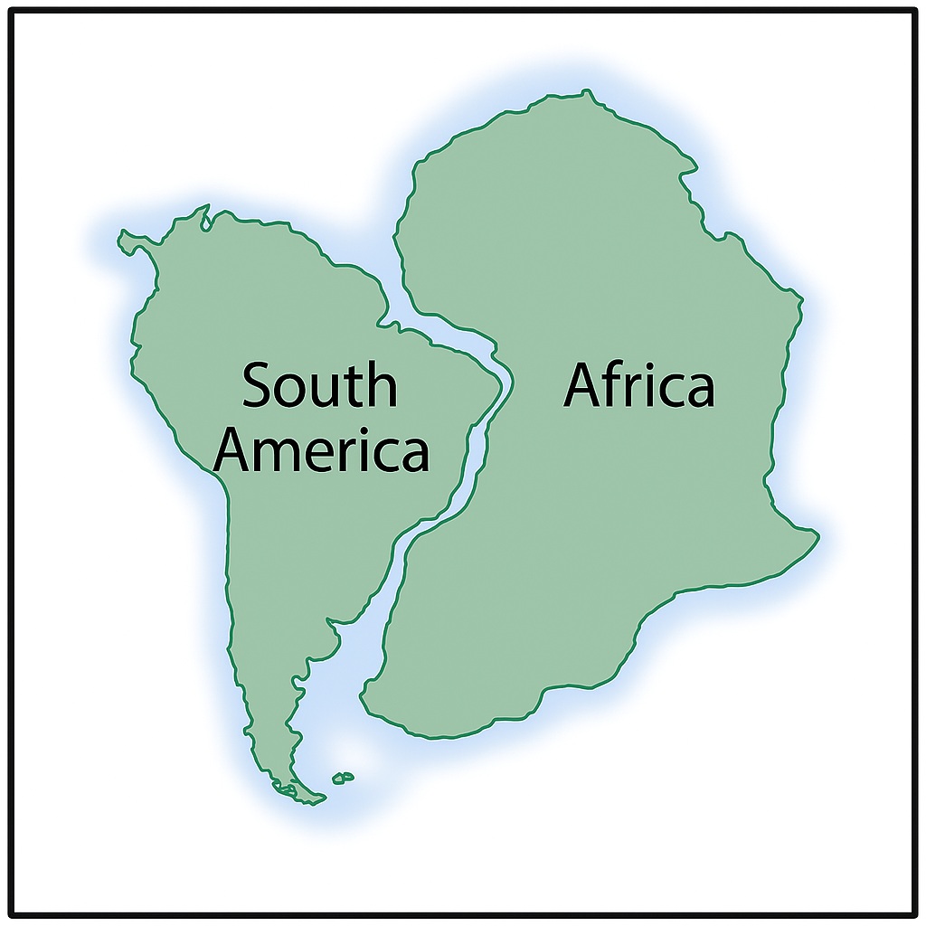
One of the most striking observations is the complementary shapes of continental coastlines, particularly the east coast of South America and the west coast of Africa. This jigsaw-like fit suggests that these continents were once connected. The coastlines of continents such as South America and Africa appear to fit together like pieces of a jigsaw puzzle.
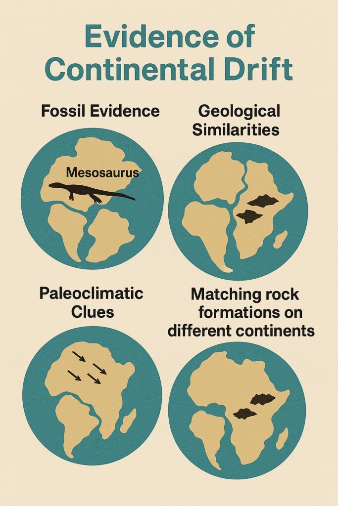
Fossil Evidence
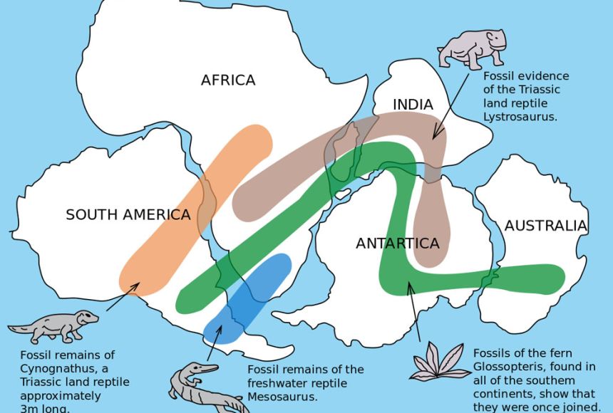
Identical fossils of plants and animals have been found on continents that are now separated by oceans, suggesting they were once connected.
"Evidence of glacial deposits in now-tropical regions and coal in Antarctica shows continents were once in different climatic zones."
Geological Evidence
Similar rock formations and mountain ranges are found on continents that are now widely separated, indicating they were once part of the same landmass.
Paleoclimatic Evidence
Evidence of past glaciations and climate patterns suggests that continents that are now located in different latitudes were once situated closer to the poles or equator.
Continental Drift Mechanism
Wegener proposed that the continents “drifted” across the Earth’s surface over geological time scales. He suggested that various forces, such as tidal forces, centrifugal forces from Earth’s rotation, and mantle convection currents, may have played a role in the movement of continents, although he did not provide a detailed mechanism.
Stage I: Pangaea
According to the theory of continental drift, around 200-300 million years ago, all the continents were assembled into a single landmass called Pangaea. This supercontinent was surrounded by a vast ocean known as Panthalassa.
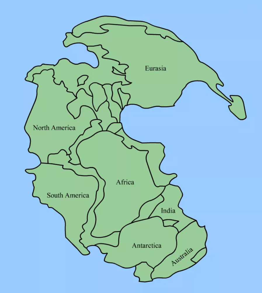
Pangaea, meaning “all lands” in Greek, was the supercontinent that existed approximately 300 million years ago during the late Paleozoic and early Mesozoic eras. Pangaea was surrounded by the super ocean known as Panthalassa. This supercontinent formed through the process of continental accretion, where smaller landmasses collided and merged to form a larger landmass.
Pangaea was characterized by a single large landmass with a relatively uniform climate and extensive inland seas. The interior of Pangaea was dominated by vast deserts and low-lying swampy areas. The breakup of Pangaea began around 200 million years ago during the Mesozoic era, leading to the formation of two smaller supercontinents: Laurasia in the northern hemisphere and Gondwana in the southern hemisphere.
Stage II: Gondwana and Laurasia
Gondwana and Laurasia were the two supercontinents that formed from the breakup of Pangaea during the Mesozoic era. Gondwana, also known as Gondwanaland, comprised the landmasses that eventually became the continents of South America, Africa, Antarctica, Australia, and the Indian subcontinent. Gondwana was located primarily in the southern hemisphere.
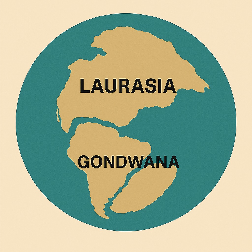
Laurasia, located primarily in the northern hemisphere, consisted of the landmasses that eventually formed North America, Europe, and Asia (excluding the Indian subcontinent). The breakup of Gondwana and Laurasia continued through the Mesozoic era and into the Cenozoic era, leading to the modern configuration of Earth’s continents.
Stage III: Modern World
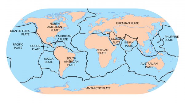
The modern world represents the current configuration of Earth’s continents, which have continued to move and evolve since the breakup of Pangaea. Today, Earth’s continents are distributed across the globe, with the Atlantic Ocean separating the Americas from Europe and Africa, and the Indian Ocean separating Africa from Asia and Australia.
The movement of Earth’s continents is driven by the process of plate tectonics, where the Earth’s lithosphere is divided into several large and small plates that move relative to each other. These movements continue to shape the Earth’s surface, leading to phenomena such as earthquakes, volcanic eruptions, and the formation of mountain ranges.
Acceptance and Further Research
Although Wegener’s theory initially faced skepticism, subsequent research in the mid-20th century provided additional evidence supporting continental drift. The development of technologies such as paleomagnetism, seismic tomography, and satellite imaging has further confirmed the movement of continents and provided a more detailed understanding of plate tectonics.
In summary, continental drift is the theory that suggests Earth’s continents were once part of a single supercontinent and have since drifted apart due to the movement of tectonic plates. This theory laid the foundation for the modern understanding of plate tectonics and has had a profound impact on the field of geology.
The theory of continental drift proposes that the continents we see today have not always been in their current positions, but have shifted and moved over time. This phenomenon has played a significant role in shaping the Earth’s surface and geography and has been the subject of intense scientific study for over a century. In this article, we’ll explore the concept in detail, including its origins, key elements, and how it has shaped our understanding of the Earth.
Impact of Continental Drift on Earth’s Surface
The theory of continental drift has had a profound impact on our understanding of the Earth’s surface and geography. It helps explain the formation of mountain ranges, earthquakes, and volcanic eruptions, as well as the distribution of plants, animals, and other life forms.
One of the most significant impacts of continental drift is the formation of mountain ranges. When two plates collide, the pressure can cause the land to be pushed up and form mountain ranges, such as the Andes in South America or the Himalayas in Asia. Similarly, earthquakes and volcanic eruptions are often associated with the movement of tectonic plates, as the plates can cause stress to build up in the Earth’s surface.
The theory of continental drift also helps explain the distribution of plants and animals around the world. It is believed that land bridges once connected different continents, allowing plants and animals to migrate and populate new areas. The breakup of these land bridges and the movement of the continents over time have caused the separation of different populations, leading to the evolution of unique species in different parts of the world.
"Continental Drift supports the idea that the Earth's surface is dynamic, constantly changing due to the movement of tectonic plates."
Conclusion
The theory has been the subject of scientific study for over a century and continues to play a significant role in our understanding of the Earth’s surface and geography. It provides valuable insights into the movements and changes of the Earth’s surface over millions of years and helps us better understand the dynamic planet we live on. The theory of continental drift has had a profound impact on our understanding of the Earth’s surface, from the formation of mountain ranges and earthquakes.