An earthquake is a sudden and rapid shaking of the Earth’s surface caused by the movement of tectonic plates. Earthquakes can range from minor tremors that are barely noticeable to major earthquakes that can cause widespread damage and destruction. They can occur anywhere in the world and are a natural hazard that poses a threat to human lives and infrastructure.
What is Focus?
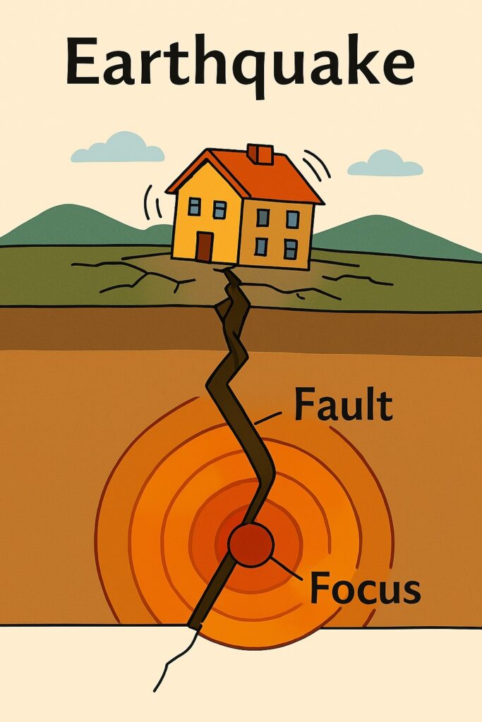
The focus of an earthquake is the point beneath the Earth’s surface where the seismic energy is released. It is the source of the energy that triggers the Earthquake.
The location of the focus of an earthquake can vary depending on the type of fault or geological structure of the region. For example, in a strike-slip fault, where two tectonic plates slide past each other horizontally, the focus is typically a relatively shallow and narrow zone where the plates are in contact. In contrast, in a subduction zone, where one tectonic plate is pushed beneath another, the focus can be deeper and more spread out.
The depth of the focus of an earthquake can also vary greatly. Shallow earthquakes, with foci less than 70 km deep, are more common and typically cause more damage to structures and infrastructure. Deeper earthquakes, with foci greater than 300 km deep, are less common and typically generate weaker seismic waves that are less likely to cause damage.
"The depth of the focus is a critical factor in determining the intensity and potential impact of the earthquake on the surface."
Table of Contents
What is Epicenter?
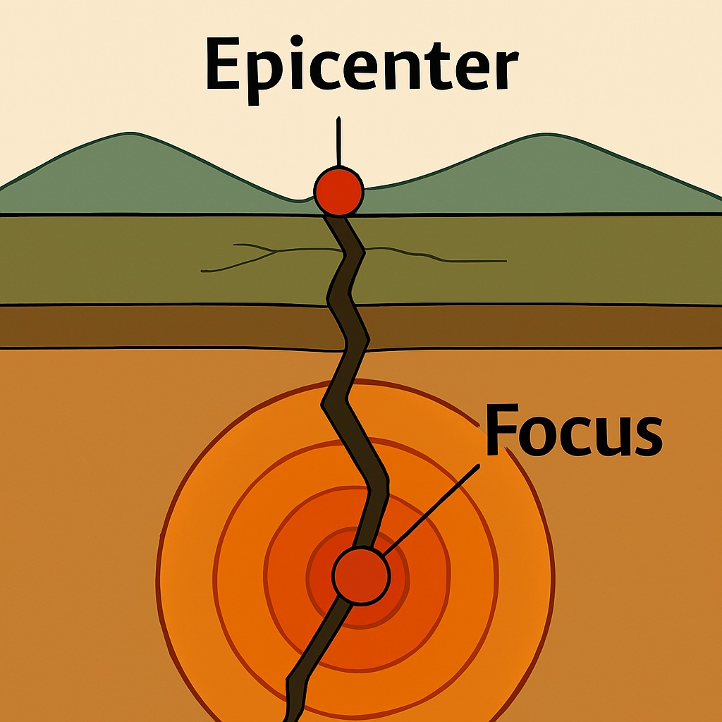
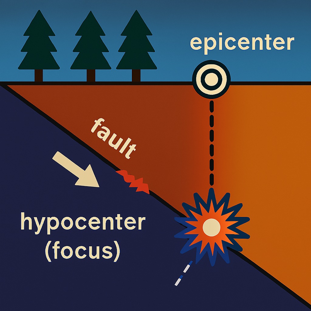
The epicenter of an earthquake is the point on the Earth’s surface that is directly above the focus or hypocenter, which is the point beneath the Earth’s surface where the earthquake originates or where the seismic energy is released.
When an earthquake occurs, seismic waves travel outward from the focus through the Earth’s crust and cause the ground to shake at the surface. The point on the surface directly above the focus, where the shaking is typically the strongest, is defined as the epicenter.
What is Fault Line?
A fault line is a geological feature where two tectonic plates meet and move relative to one another. The movement of these plates can cause stress to build up in the Earth’s crust, and when the stress reaches a critical point, it can cause the rocks on either side of the fault to shift suddenly. This movement generates seismic waves that can cause earthquakes.
"Faults are areas where the Earth's crust is weak or fractured, and they can cause earthquakes when they shift or break apart."
Fault lines can vary in size and shape, and they can be found all over the world. Some fault lines, like the San Andreas Fault in California, are well-known for their high levels of seismic activity, while others are less active and may not be as well-studied.
There are three main types of fault lines: strike-slip faults, normal faults, and reverse faults. Strike-slip faults occur when two tectonic plates slide past each other horizontally. Normal faults occur when the rocks on one side of the fault move downward relative to the rocks on the other side. Reverse faults occur when the rocks on one side of the fault move upward relative to the rocks on the other side.
Earthquake Waves
Body waves
Body waves are seismic waves that travel through the interior of the Earth, propagating outward from the focus of an earthquake. Body waves play a crucial role in providing information about the Earth’s internal structure and the properties of seismic events. There are two types of body waves: P wave and S wave.
Primary Waves (P-Waves)
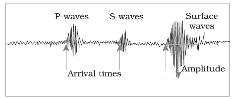
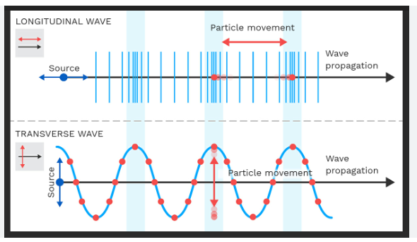
P-waves are the fastest seismic waves and are the first to be recorded by seismographs following an earthquake. They are compressional waves, meaning that they cause particles of the Earth’s material to move back and forth in the direction of wave propagation. These are longitudinal waves that travel faster than other seismic waves and are the first waves to arrive at a seismic station.
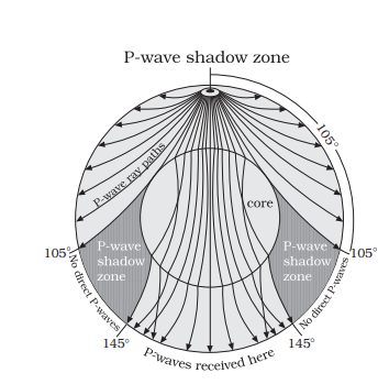
P-waves can travel through both solids and liquids, which allows them to pass through the Earth’s interior without significant loss of energy. These waves are capable of traveling through all layers of the Earth, including the crust, mantle, and core.
"P waves are the first waves to arrive at a seismic station"
Secondary Waves (S-Waves)
S-waves are slower than P-waves and arrive at seismographs after P-waves. They are transverse waves, meaning that they cause particles of the Earth’s material to move perpendicular to the direction of wave propagation.
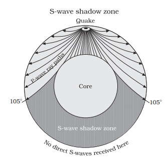
Unlike P-waves, S-waves cannot travel through liquids, such as the Earth’s outer core, because liquids do not support the shear stress required for transverse wave motion. S-waves can only propagate through solids, which limits their ability to travel through the Earth’s outer core.
Comparison: P Wave and S Wave
| P-Waves | S-Waves |
|---|---|
| Primary waves | Secondary waves |
| Longitudinal waves | Transverse waves |
| Travel faster than S-waves | Travel slower than P-waves |
| Can travel through solid, liquid, and gas | Can only travel through solid material |
| Are the first waves to arrive at a seismic station | Arrive after P-waves |
| Cause less damage | Cause more damage |
| Can be detected by a vertical seismograph | Can be detected by a horizontal seismograph |
| Used to determine the location, depth, and magnitude of an earthquake | Used to study the Earth’s interior and composition |
Use of Body Waves
The behavior of P-waves and S-waves as they travel through the Earth provides valuable information about the Earth’s internal structure, like the composition, density, and state of materials within the Earth’s layers.
Surface Waves
Surface waves are a type of seismic wave that travel along the Earth’s surface. Unlike body waves, which travel through the Earth’s interior, surface waves are confined to the Earth’s outermost layer. These waves are generated during an earthquake and are responsible for the majority of the damage and ground shaking observed at the Earth’s surface.
There are two main types of surface waves:
Love Waves (L-Waves)
Love waves are horizontally polarized shear waves, meaning that they cause the ground to move perpendicular to the direction of wave propagation. These waves travel near the Earth’s surface and produce a side-to-side motion similar to the movement of a snake slithering across the ground.
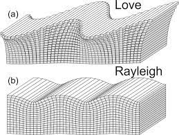
Love waves are relatively slower than other types of seismic waves but can cause significant horizontal shaking and damage to structures.
Rayleigh Waves (R-Waves)
Rayleigh waves are the most significant and destructive type of surface wave. They have both vertical and horizontal motion, with the ground moving in an elliptical or rolling motion as the wave passes through.
Rayleigh waves travel along the Earth’s surface and gradually decrease in amplitude with depth. These waves are responsible for the characteristic rolling motion experienced during earthquakes and can cause extensive damage to buildings, infrastructure, and natural landscapes.
Surface waves play a crucial role in earthquake engineering and seismology.
Significance of Surface Wave
By analyzing the characteristics of surface waves recorded by seismographs, scientists can gain insights into the size, location, and depth of an earthquake, as well as the properties of the Earth’s surface and subsurface layers.
Causes of Earthquake
Tectonic Activity
An earthquake is caused by the sudden release of energy in the Earth’s crust that creates seismic waves. The energy is released when two tectonic plates that make up the Earth’s surface move against each other or break apart.
The movement of the Earth’s crustal plates is the primary cause of earthquakes. The movement can cause pressure to build up at the boundaries between the plates, resulting in an earthquake.
Volcanic Activity
Volcanic activity, such as the eruption of a volcano or the movement of magma within the Earth’s crust, can cause earthquakes.
Human Activities
Some human activities, such as the construction of large dams or underground mining, can cause earthquakes.
Meteorite Impacts
Large meteorite impacts can also cause earthquakes, but these are rare events.
Nuclear Testing
Nuclear explosions and underground nuclear testing can cause seismic waves that mimic the effects of an earthquake.
Glacial Rebound
The melting of glaciers can cause the Earth’s crust to rebound, which can result in earthquakes.
Effects of Earthquake
The effects of an earthquake can vary depending on factors such as magnitude, depth, distance from the epicenter, and local geological conditions. Some common effects are:
Ground Shaking
The primary effect of an earthquake is the shaking of the ground, which can range from mild to severe depending on the earthquake’s magnitude. This shaking can cause buildings and infrastructure to sway, leading to structural damage and collapse.
Surface Rupture
In some cases, earthquakes can cause the ground to rupture along fault lines, resulting in visible cracks and displacement of the Earth’s surface.
Structural Damage
Earthquakes can cause extensive damage to buildings, bridges, roads, and other infrastructure. Poorly constructed or unreinforced structures are particularly vulnerable to collapse.
Landslides and Avalanches
Earthquakes can trigger landslides on steep slopes, leading to the rapid movement of soil, rocks, and debris. Similarly, earthquakes in mountainous regions can trigger avalanches, posing additional hazards.
Tsunamis
Underwater earthquakes or those occurring near coastlines can generate tsunamis, which are large ocean waves capable of causing widespread flooding and destruction along coastal areas.
Loss of Life and Injury
Earthquakes can result in loss of life and injuries due to collapsed buildings, falling debris, landslides, tsunamis, and other hazards associated with the event.
How animals sense the Earthquake waves in advance?
Animals have long been known to have the ability to sense impending earthquakes. This ability has been observed in a wide range of species, from domestic pets to wild animals. While the exact mechanism by which animals sense earthquakes is not fully understood, there are several theories that have been proposed.
One theory is that animals are able to sense changes in the Earth’s magnetic field that occur prior to an earthquake. It is thought that the movement of tectonic plates generates electric currents, which in turn create changes in the Earth’s magnetic field. Some animals, such as birds and sea turtles, are known to have the ability to detect changes in the Earth’s magnetic field and use this ability to navigate. It is possible that this same sense is used to detect changes in the Earth’s magnetic field that occur prior to an earthquake.
Recent Earthquakes
Recent earthquakes have also had a significant impact on the world. The earthquake in Nepal in 2015 was one of the deadliest earthquakes in recent history, with over 9,000 people killed and millions left homeless. The earthquake in Haiti in 2010 also had a devastating impact, with over 200,000 people killed and many more injured or displaced.
The Role of Science and Technology
Science and technology have played an important role in improving earthquake prediction, preparedness, and mitigation. Seismologists use a variety of tools and techniques to monitor seismic activity and predict when earthquakes are likely to occur. This includes using seismometers, GPS sensors, and satellite imagery to detect changes in the Earth’s crust.
Technology has also played a role in improving earthquake-resistant building design. Computer models are used to simulate the behavior of buildings during an earthquake, helping engineers to identify potential weaknesses and make design improvements. Advanced materials and building techniques are also being developed to improve the resilience of buildings to seismic activity.
Distribution of Earthquake in World
Earthquakes occur throughout the world, but their distribution is not uniform. They tend to be more frequent and more severe in certain areas, which are often located near tectonic plate boundaries or within areas of active volcanism. Some of the most earthquake-prone regions in the world include:
The Pacific Ring of Fire
This is a region that circles the Pacific Ocean, including the west coast of North and South America, Asia, and Oceania. It is characterized by a high degree of volcanic and seismic activity, including the most powerful earthquakes in history.
The Mediterranean-Asian seismic belt: This region stretches from the Alps to the Himalayas and includes the Mediterranean, the Middle East, and Asia. It is another active seismic region due to the collision of the African and Eurasian plates.
The Mid-Atlantic Ridge: This is an underwater mountain range that runs down the center of the Atlantic Ocean. It is the site of frequent seismic activity and volcanic eruptions, and it marks the boundary between the Eurasian and North American plates and the African and South American plates.
The Caribbean: The Caribbean region is also known for seismic activity, with many earthquakes occurring along the boundary between the North American and Caribbean plates.
It’s worth noting that earthquakes can occur anywhere in the world, and even regions that are not considered particularly earthquake-prone can experience significant seismic activity.
Preparing for Earthquake
Preparation is key to minimizing the impact of earthquakes. Emergency preparedness, earthquake drills, and building codes are all important aspects of earthquake preparedness. Emergency preparedness involves having a plan in place for when an earthquake strikes, such as knowing where to go and what to do in case of an earthquake. Earthquake drills help people practice what to do in the event of an earthquake, and building codes ensure that buildings are constructed to withstand earthquakes.
Mitigating the Impact of Earthquakes
In addition to preparation, there are also ways to mitigate the impact of earthquakes. Early warning systems can provide advance notice of an impending earthquake, giving people time to take necessary precautions.
Measurement of Earthquake
Earthquakes are measured using seismographs, which record the seismic waves produced by the earthquake. There are several different scales used to measure the size and intensity of an earthquake, including:
Magnitude scale
The magnitude of an earthquake is a measure of the amount of energy released by the earthquake. The most commonly used magnitude scale is the Richter scale, which is based on the amplitude of the seismic waves recorded on a seismograph. The Richter scale ranges from 0 to 10, with each increase of 1 representing a tenfold increase in the magnitude of the earthquake.
Intensity scale
The intensity of an earthquake is a measure of the effects of the earthquake on people, buildings, and other structures. The most commonly used intensity scale is the Modified Mercalli Intensity Scale, which ranges from I to XII, with each increase in intensity representing a higher level of damage and shaking.
The magnitude and intensity of an earthquake can have significant impacts on the surrounding area, including damage to buildings, infrastructure, and human life. Therefore, accurate measurement and reporting of earthquakes are essential for understanding the potential impacts and implementing effective emergency response measures.
Relation Between earthquake and Tsunami
Earthquakes and tsunamis are often related because tsunamis are commonly triggered by earthquakes that occur underwater. When an earthquake occurs beneath the ocean floor, the sudden movement of tectonic plates can cause a displacement of water, which creates waves that travel outward from the epicenter of the earthquake. These waves are called tsunami waves, and they can travel across entire ocean basins, causing widespread devastation when they reach the shore.
The magnitude of the earthquake and the depth and location of the epicenter can all impact the severity of the resulting tsunami. Generally, larger earthquakes that occur at shallower depths and closer to the coastline are more likely to generate larger and more destructive tsunamis.
It’s important to note that not all earthquakes trigger tsunamis. Some earthquakes occur too deep or too far from the coast to generate significant tsunami waves. Additionally, some tsunamis are not triggered by earthquakes, but instead by other events such as landslides or volcanic eruptions that displace large amounts of water.
Overall, the relationship between earthquakes and tsunamis highlights the importance of monitoring seismic activity and coastal areas for early warning signs of potential tsunamis, and having emergency plans and procedures in place to minimize the impact of these devastating events.
Earthquake zones in India
India is located in a seismically active region, and the country is divided into four seismic zones based on the intensity and frequency of earthquakes. These zones are:
Zone 2: This zone covers areas that are considered to be at moderate risk of earthquakes. It includes parts of central India.
Zone 3: This zone covers areas that are considered to be at moderate to high risk of earthquakes. It includes parts of Gujarat, Rajasthan, Madhya Pradesh, Maharashtra, Chhattisgarh, Orissa, West Bengal, Bihar, Jharkhand, and the Andaman and Nicobar Islands.
Zone 4: This zone covers areas that are considered to be at high risk of earthquakes. It includes parts of Jammu and Kashmir, Himachal Pradesh, Uttar Pradesh, Bihar, West Bengal, Sikkim, the north-eastern states, and some areas in western and central India.
Zone 5: This zone covers areas that are considered to be at very high risk of earthquakes. It includes parts of Jammu and Kashmir, Himachal Pradesh, Uttarakhand, and the north-eastern states.
Preventing Earthquake
There is no way to prevent earthquakes from occurring, but there are steps that can be taken to minimize their impact on human populations and infrastructure. These steps include the implementation of building codes and regulations, the construction of earthquake-resistant buildings, and the development of early warning systems.
Read: Geography