The Gangotri Glacier is one of the largest glaciers in the Himalayas and is located in the state of Uttarakhand in northern India. It is the primary source of the Ganges River, one of the most sacred rivers in Hinduism. The glacier is situated in the Garhwal Himalayas, at an elevation of about 4,100 meters (13,500 feet) above sea level.
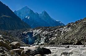
Table of Contents
Features of Gangotri Glacier
The Gangotri Glacier is approximately 30 kilometers long and flows in a northwest direction. It is surrounded by several towering peaks, including Shivling, Thalay Sagar, Meru, and Bhagirathi III. The glacier is fed by the accumulation of snow over the years, and as the ice melts, it gives rise to the Bhagirathi River, which eventually joins the Alaknanda River to form the Ganges River at the confluence known as Devprayag.
It holds significant religious and cultural importance in India, as the Ganges River is considered sacred by Hindus. The town of Gangotri, situated near the glacier, is a popular pilgrimage site, especially during the Char Dham Yatra, a sacred journey that includes visits to Gangotri, Yamunotri, Kedarnath, and Badrinath.
It’s important to note that glaciers worldwide are vulnerable to the effects of climate change, and the Gangotri Glacier is no exception. Monitoring and studying the glacier’s health and changes are essential for understanding the impact of climate change on water resources in the region.
What is a Glacier?
A glacier is a large, persistent mass of ice that forms over time from the accumulation, compaction, and recrystallization of snow. Glaciers are found on land and are distinct from sea ice, which forms in polar oceans. These icy formations are a crucial component of Earth’s cryosphere, playing a significant role in shaping the landscape and influencing global climate.
Important characteristics and features of glaciers:
- Formation: Glaciers form in areas where snow accumulates and undergoes a process of compaction and recrystallization, transforming the snow into firn and eventually into dense glacial ice.
- Movement: Glaciers are not static; they move slowly under their own weight due to the force of gravity. This movement is typically measured in centimeters to meters per day. Glacial flow can cause erosion, transport of sediment, and the creation of distinctive landforms.
- Zones: Glaciers typically have zones with different characteristics. The accumulation zone is where snow and ice accumulate, while the ablation zone is where ice is lost through melting or calving. The equilibrium line is the boundary between these zones.
- Landforms: Glaciers carve out various landforms as they move, including valleys, cirques, aretes, and moraines. These features are often distinctive and can be used to identify past glacial activity in a region.
- Importance: Glaciers are significant contributors to Earth’s hydrological cycle. They store vast amounts of freshwater, and as they melt, they release water into rivers and lakes, influencing regional water resources. Additionally, they play a role in reflecting sunlight, contributing to the regulation of the Earth’s temperature.
- Climate Indicators: Changes in the size and behavior of glaciers can serve as indicators of climate change. The retreat or advance of glaciers is closely monitored as a signal of broader shifts in temperature and precipitation patterns.
Examples of well-known glaciers include the Antarctic and Greenland ice sheets, as well as smaller mountain glaciers like the Gangotri Glacier in the Himalayas or the Franz Josef Glacier in New Zealand.