The latitudinal division of Himalaya is the horizontal division of the geomorphic features of the great mountain range. It spans six countries and is the highest and longest mountain range on the planet. The range is divided into several parts based on various geographical, geological, and cultural factors.
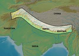
Table of Contents
Great Himalayan Range
The Great Himalayan Range is a massive mountain range located in Asia, spanning across several countries including India, Nepal, Bhutan, Pakistan, and China. It is the highest mountain range in the world and is known for its majestic peaks, deep valleys, and diverse flora and fauna.
The range is approximately 2,400 kilometers long and 250-300 kilometers wide, with an average elevation of over 4,500 meters above sea level. The highest peak in the range is Mount Everest, which stands at an elevation of 8,848 meters and is located on the Nepal-China border.
The Great Himalayan Range is also home to many other prominent peaks, such as Kanchenjunga and Dhaulagiri. The range is also the source of many major rivers, including the Indus, Ganges, Brahmaputra, and Yangtze.
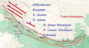
Latitudinal Division of Himalaya
Following is the latitudinal division of Himalaya.
- Trans Himalaya
- Greater Himalaya
- Lesser Himalaya
- Shiwalik
Trans Himalaya
The Trans Himalaya is also known as the Tibetan Himalaya. It is a mountainous region located in the most-northern part of the Himalaya range. It is an extension of the Himalayan mountain range that stretches across Tibet, Bhutan, Nepal, and India.
The Trans Himalaya is characterized by high-altitude plateaus, deep canyons, and towering peaks. The region is also home to several major rivers, including the Indus, the Brahmaputra, and the Sutlej.
The range is mostly composed of volcanic and granite rocks. The vegetation in the region is sparse, with mainly grasslands and shrubs found at lower elevations, and no trees or vegetation above a certain altitude.
Karakoram Range
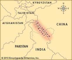
The Karakoram Range is a mountain range located in the northernmost part of the Indian subcontinent, spanning the borders of Pakistan, India, and China. It is one of the highest and most rugged mountain ranges in the world, with several peaks rising above 8,000 meters, including K2, the second-highest mountain in the world.
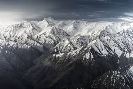
The Karakoram Range is characterized by sharp, jagged peaks, deep valleys, and glaciers. It is home to some of the world’s largest glaciers outside of the polar regions, including the Siachen Glacier, which is the longest glacier in the world outside of the polar regions. The region is also home to several important rivers, including the Indus, the Shyok, and the Nubra, which are a major source of water for the region.
The Karakoram Range is located at the intersection of the Indian and Eurasian tectonic plates, and is therefore prone to earthquakes and landslides. The region is also characterized by extreme weather conditions, with temperatures dropping below -50°C in the winter and high winds and snowfall in the summer.
The Karakoram Range is an important cultural and historical region, with several ancient trade routes passing through it, connecting India and Central Asia. The region is home to several ethnic groups, including the Baltis, the Burushos, and the Wakhi people. The region is also home to several important religious sites, including the famous Silk Road-era Karakoram Highway.
Ladakh Range
Ladakh is a region located in the northernmost part of India, in the state of Jammu and Kashmir. It is a high-altitude desert.
Ladakh has a rich cultural and historical heritage, and is home to several ancient Buddhist monasteries and other religious sites. The region is also known for its unique cuisine, traditional handicrafts, and stunning natural landscapes, including vast expanses of rugged mountains, pristine lakes, and frozen rivers.
Tourism is one of the main industries in Ladakh, and visitors come from all over the world to experience its beauty and culture. However, the region also faces several challenges, including environmental degradation, cultural preservation, and political instability due to the ongoing conflict between India and Pakistan over the territory of Jammu and Kashmir.
Zaskar Range
The Zaskar Range runs parallel to the Great Himalayan Range and is located south of Ladakh Range.
The Zaskar Range is known for its rugged and challenging terrain, with peaks rising to heights of over 6,000 meters. The range is popular among mountaineers and trekkers, and several expeditions have been undertaken to climb the peaks in the region.
Kailash range
The Kailash Range is a mountain range located in the western part of the Himalayas, primarily in the Tibet Autonomous Region of China, but also extending into India and Nepal. The range is named after Mount Kailash, which is considered a sacred peak by several religions, including Hinduism, Buddhism, and Jainism.
The Kailash Range is known for its stunning natural beauty and rugged terrain, with peaks rising to heights of over 6,000 meters. In addition to Mount Kailash, some of the other notable peaks in the range include Gurla Mandhata, Mount Api, and Mount Nampa.
The Kailash Range is also home to several important rivers, including the Indus, Sutlej and Brahmaputra. These rivers are an important source of water for millions of people in the region and are vital for agriculture, hydropower, and other economic activities.
The Greater Himalaya
The Greater Himalaya region is characterized by high peaks, glaciers, and snowfields and is also known by several other names as Himadri or central Himalaya. It is mainly formed by Granites and other sedimentary rocks. The range has been formed by asymmetrical folding, having steep southern slope and gentle north slope.
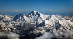
The highest peak in the world the Mount Everest is located on this range.
The Lesser Himalaya
The Lesser Himalaya is a region of the Himalayan mountain range that lies to the south of the Great Himalayas and to the north of the Siwalik Hills. It extends for about 2,400 km from the Indus River in the west to the Brahmaputra River in the east, and has an average width of about 100 km.
The Lesser Himalaya is characterized by a series of parallel ranges and valleys, with elevations ranging from about 1,000 to 4,000 meters above sea level. The region is known for its rugged terrain, deep valleys, and steep slopes, and is home to a diverse array of flora and fauna.
Shiwalik
The Siwalik Hills, also known as the Outer Himalayas, is a mountain range in South Asia that runs parallel to the Himalayas, separating the Indo-Gangetic Plain from the foothills of the Himalayas. The range extends over 2,400 km from the Jammu region in the west to the Brahmaputra Valley in the east, and is approximately 10-50 km wide.
The Siwalik Hills are composed of sedimentary rocks and are characterized by a series of low hills and valleys with elevations ranging from about 600 to 1,500 meters above sea level.
The Siwalik Hills are also known for their rich biodiversity and are home to a diverse array of flora and fauna. The region is known for its tropical forests, grasslands, and wetlands, and is home to a number of endangered species, including the Indian rhinoceros, Bengal tiger, and Asian elephant.
The Siwalik Hills have been inhabited by humans for thousands of years and are home to many small communities that rely on the natural resources of the region for their livelihoods. The region is also an important area for agriculture and forestry, and is home to many important wildlife reserves and national parks.
Latitudinal Division of Himalaya : Summary
- The Great Himalayan Range is a massive mountain range located in Asia, spanning across several countries including India, Nepal, Bhutan, Pakistan, and China.
- It is the highest mountain range in the world and is known for its majestic peaks, deep valleys, and diverse flora and fauna.
- The range is approximately 2,400 kilometers long and 250-300 kilometers wide, with an average elevation of over 4,500 meters above sea level.
- The Great Himalayan Range is also home to many other prominent peaks, such as Kanchenjunga and Dhaulagiri.
- The range is also the source of many major rivers, including the Indus, Ganges, Brahmaputra, and Yangtze.
- The Himalayan mountain range can be divided into following regions, based on its physiographic features: Trans Himalaya, Greater Himalaya, Lesser Himalaya, and Shiwalik.
- The Trans Himalaya is also known as the Tibetan Himalaya. It is a mountainous region located in the most-northern part of the Himalaya range. It is an extension of the Himalayan mountain range that stretches across Tibet, Bhutan, Nepal, and India.
- The Karakoram Range is a mountain range located in the northernmost part of the Indian subcontinent, spanning the borders of Pakistan, India, and China. It is one of the highest and most rugged mountain ranges in the world, with several peaks rising above 8,000 meters, including K2, the second-highest mountain in the world.
- Ladakh is a region located in the northernmost part of India, in the state of Jammu and Kashmir. It is a high-altitude desert.
- The Zaskar Range runs parallel to the Great Himalayan Range and is located south of Ladakh Range.
- The Kailash Range is a mountain range located in the western part of the Himalayas, primarily in the Tibet Autonomous Region of China, but also extending into India and Nepal.
Latitudinal Division of Himalaya : MCQ
Q. What is the highest peak in the Himalayan range?
a) Kanchenjunga
b) Everest
c) Annapurna
d) Makalu
Answer: b) Everest
Explanation: Mount Everest is the highest peak in the Himalayan range and the world, with a height of 8,848 meters.
Q. Which river originates from the Himalayas and flows through Pakistan?
a) Ganga
b) Brahmaputra
c) Indus
d) Yamuna
Answer: c) Indus
Explanation: The Indus river originates from the Himalayas in Tibet and flows through Pakistan, ultimately emptying into the Arabian Sea.
Q. The Himalayas are a result of:
a) Tectonic activity
b) Erosion
c) Volcanic activity
d) Meteorite impact
Answer: a) Tectonic activity
Explanation: The Himalayan range was formed due to the collision of the Indian and Eurasian tectonic plates around 50 million years ago. The ongoing movement of these plates is still causing the range to rise.
Important Links