Geography
- Paper Time: 3 hours
- Full Marks : 300
- The figures in the right-hand margin indicate marks.
- Candidates should attempt Q. No. 1 from Section-A and Q. No. 5 from Section B which are compulsory and any three of the remaining questions, selecting at least one from each Section.
SECTION-A
1. Mark the correct location of the following on the map given to you and write the most significant points of each in not more than 10 words:
6×10 60
(a) River Nile
(b) Swaraj Dweep
(c) Sunderbans
(d) Aravallis
(e) Palk bay
(f) Prairies
(g) Caspian sea
(h) Greenwich
(i) Suez canal
(j) Equatorial counter current
2. Discuss the concept of the cycle of erosion as propounded by W. M. Davis. 60
3. What are the basic requirements for the development of a tropical cyclone ? Describe weather sequence of an approaching tropical cyclone. Why do they dissipate over the land ? 60
4. What are coral reefs ? State the favorable conditions necessary for the growth and development of corals. Explain the nature and mode of occurrences of different types of coral reefs with suitable illustrations. 60
SECTION-B
5. Answer any three of the following: 60
(a) Causes of migration
(6) Rostow’s stages of development
(c) Primate city
(d) Limit to growth
6. Examine the contribution of geographers in the development of Behavioural Geography. 60
7. Elucidate the theory of industrial location as proposed by David M. Smith. Give criticism. 60
8. What is a region ? Classify regions stating the bases of their classification. 60
SOLUTION
1. Mark the correct location of the following on the map given to you and write the most significant points of each in not more than 10 words:
6×10 60
(a) River Nile
(b) Swaraj Dweep
(c) Sunderbans
(d) Aravallis
(e) Palk bay
(f) Prairies
(g) Caspian sea
(h) Greenwich
(i) Suez canal
(j) Equatorial counter current
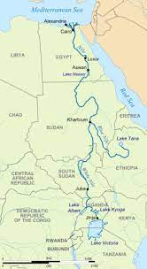
(a) River Nile: The River Nile is a major north-flowing river in northeastern Africa. It is the longest river in the world. It flows through multiple countries, including Egypt, Sudan, Ethiopia, Uganda, and others. The Nile has played a crucial role in the development of ancient civilizations, providing water for irrigation and fertile lands for agriculture along its banks.
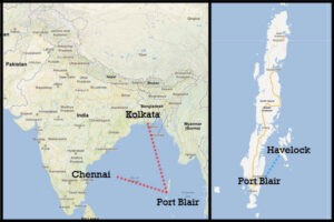
(b) Swaraj Dweep: Swaraj Dweep is a beautiful island situated in the Andaman and Nicobar archipelago of India. It is a popular tourist destination. It is also called Havelock Island.
(c) Sunderbans: The Sunderbans is a vast mangrove forest located in the delta region of the Ganges, Brahmaputra, and Meghna rivers in India and Bangladesh. It is a UNESCO World Heritage Site and home to the iconic Bengal tiger. The Sunderbans is known for its unique biodiversity, with numerous plant and animal species adapted to the brackish water ecosystem.

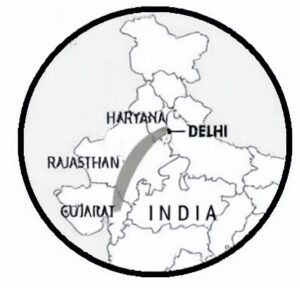
(d) Aravallis: The Aravalli Range is a mountain range in northwestern India, stretching across the states of Gujarat, Rajasthan, Haryana, and Delhi. It is one of the oldest mountain ranges in the world and serves as a prominent geographical feature of the Indian subcontinent. The Aravallis are ecologically significant, providing a habitat for diverse flora and fauna.
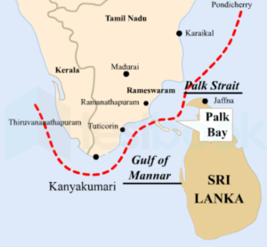
(e) Palk Bay: Palk Bay is a shallow water body located between the southeastern coast of India (Tamil Nadu) and the northern coast of Sri Lanka. It is a part of the Bay of Bengal and serves as a crucial fishing zone for both countries. The region is known for its marine biodiversity and is an important migratory route for marine species.
(f) Prairies: Prairies are vast, flat grasslands characterized by fertile soils and temperate climates. They are found in various parts of the world, including North America, Eurasia, and South America. The North American Prairies, also known as the Great Plains, stretch across the central United States and Canada and are known for their agricultural importance.

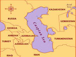
(g) Caspian Sea: The Caspian Sea is a large, enclosed inland body of water located between Europe and Asia. It is the world’s largest inland body of water by both surface area and volume. The Caspian Sea is bordered by five countries: Russia, Kazakhstan, Turkmenistan, Iran, and Azerbaijan. It is rich in oil and gas reserves and plays a significant role in regional trade and transportation.
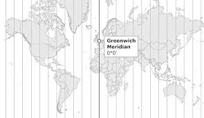
(h) Greenwich: Greenwich is a district in London, United Kingdom, known for its historical and cultural significance. It is the location of the Prime Meridian (0 degrees longitude) and the Greenwich Observatory, which has been a center for astronomical observations since the 17th century. The Prime Meridian is used as the reference for measuring time zones around the world.
(i) Suez Canal: The Suez Canal is an artificial waterway that connects the Mediterranean Sea to the Red Sea, allowing ships to navigate between Europe and Asia without the need for a lengthy and hazardous trip around the southern tip of Africa. It is a critical trade route, facilitating the transportation of goods between the East and the West.

(j) Equatorial Counter Current: The Equatorial Counter Current is an oceanic current that flows eastward along the equator, opposing the westward-flowing equatorial currents. It is present in both the Atlantic and the Pacific Oceans. The Equatorial Counter Current plays a crucial role in the Earth’s climate system and the redistribution of heat and energy.

2. Discuss in detail the concept of the cycle of erosion as propounded by W. M. Davis. (60)
Ans: The concept of the cycle of erosion, also known as the geographical cycle or Davisian cycle, was proposed by the American geographer William Morris Davis in the late 19th and early 20th centuries. Davis is considered one of the founding figures of geomorphology, the study of landforms and the processes that shape them. The cycle of erosion is a theoretical model that describes the long-term evolution of landforms through the continuous interplay of various geomorphic processes.
Key Concepts of the Cycle of Erosion:
- Equilibrium Model: Davis proposed that landscapes tend to move towards a state of dynamic equilibrium over time. This means that landforms adjust themselves to achieve a balance between the uplift of new rocks and the processes of erosion that wear them down.
- Stages of Development: According to Davis, the cycle of erosion consists of several stages through which a landscape evolves. These stages include youth, maturity, and old age. Each stage represents a different level of topographic development and is characterized by specific landforms.
- Gradual Evolution: Davis emphasized the gradual nature of landscape evolution. Landforms change over geological time through a series of slow and continuous processes, such as weathering, erosion, and sedimentation.
- Concept of Peneplanation: One of the key ideas in Davis’s cycle of erosion is the concept of peneplanation. Peneplanation refers to the hypothetical reduction of an entire landscape to a featureless plain by continuous erosion. According to Davis, landscapes tend to progress towards peneplanation over time.
Stages of the Cycle of Erosion:
- Youth Stage: The youth stage is characterized by high relief and steep slopes. The landscape is dominated by processes such as fluvial erosion, glaciation, or tectonic uplift, which create deep valleys, rugged mountains, and other sharp landforms. The drainage pattern is typically immature, with narrow, V-shaped valleys.
- Maturity Stage: As the landscape undergoes further erosion, the maturity stage sets in. During this stage, the relief becomes less steep as the forces of erosion continue to wear down the landforms. River valleys widen, and the landscape takes on a more subdued appearance. The drainage pattern becomes more integrated, forming meandering rivers and broader valleys.
- Old Age Stage: In the old age stage, the landscape approaches a state of relative flatness, and the landforms become more subdued. The landscape achieves a state of greater equilibrium, and the erosion processes tend to match the uplift rates. The rivers exhibit a more dendritic (tree-like) drainage pattern, and the landforms are characterized by broad plains and low-relief features.
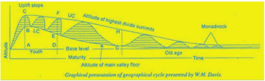
Criticisms and Limitations:
While the cycle of erosion proposed by Davis was groundbreaking and influential, it has also faced criticism and has been subject to modifications and refinements by subsequent geomorphologists. Some of the criticisms and limitations of the Davisian cycle include:
- Simplification: The cycle of erosion is a simplified model that does not consider the complexities and variations that can occur in different landscapes.
- Time Scale: The cycle operates over long geological time scales, making it challenging to directly observe the entire cycle in action.
- Human Impact: The cycle of erosion does not take into account the significant impact of human activities on landscapes, such as deforestation, urbanization, and agriculture.
- Equilibrium Assumption: The assumption of a dynamic equilibrium has been criticized, as landscapes are subject to continual changes due to tectonic activity and climatic shifts.
Conclusion:
Despite its limitations, William Morris Davis’s cycle of erosion remains a significant contribution to the understanding of landscape evolution. It provided a conceptual framework for examining how landscapes change over time through the interactions of geological processes. While modern geomorphology has advanced significantly since Davis’s time, the cycle of erosion laid the foundation for further research and continues to be a fundamental concept in the study of landforms and landscape dynamics.
3. What are the basic requirements for the development of a tropical cyclone ? Describe weather sequence of an approaching tropical cyclone. Why do they dissipate over the land? (60)
Ans: The development of a tropical cyclone, also known as a hurricane or typhoon, requires specific atmospheric and oceanic conditions. The basic requirements for the development of a tropical cyclone are as follows:
- Warm Ocean Water: Tropical cyclones derive their energy from warm ocean waters. The sea surface temperature needs to be at least 26.5°C (around 80°F) or higher, extending to a sufficient depth to provide heat and moisture to the atmosphere.
- Atmospheric Instability: An unstable atmosphere is essential for the development of convection and thunderstorms. It allows warm, moist air at the surface to rise rapidly, creating an area of low pressure.
- Coriolis Effect: The Coriolis effect, caused by the Earth’s rotation, is necessary for the cyclone’s rotation and organization. It ensures that the winds converge towards the low-pressure center, initiating the cyclonic circulation.
- Low Vertical Wind Shear: Vertical wind shear, the change in wind direction and speed with height, should be low. High wind shear can disrupt the organization of the cyclone and inhibit its development.
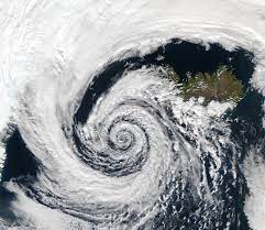
Weather Sequence of an Approaching Tropical Cyclone:
As a tropical cyclone approaches an area, the weather sequence can be summarized in the following stages:
- Pre-Storm Phase: Prior to the cyclone’s arrival, the weather may appear relatively calm, with light winds and increasing humidity. Cloud cover may increase, and the sky may become overcast.
- Initial Rain-bands: As the cyclone approaches, outer rain-bands may be the first noticeable sign. These are bands of heavy rain and gusty winds that spiral outward from the center of the storm.
- Intensification of Rain and Winds: As the cyclone nears, rain becomes heavier, and winds intensify. The cyclone’s eye, a region of calm and clear skies at the center, may become visible if the storm is well-organized.
- Eye Wall: The most intense part of the cyclone is the eye wall, which surrounds the eye. It consists of the strongest winds and heaviest rainfall.
- Eye Passage: If the cyclone’s eye passes directly over an area, there may be a temporary lull in the weather, with lighter winds and clearing skies. However, the storm resumes with renewed intensity as the opposite side of the eye wall approaches.
Dissipation of Tropical Cyclones Over Land:
Tropical cyclones dissipate over land due to several factors:
- Loss of Warm Oceanic Energy: As the cyclone moves over land, it loses its primary energy source, warm ocean waters. Land surfaces do not provide sufficient heat and moisture to sustain the storm’s strength.
- Increased Friction: The rough surface of the land creates more friction on the storm’s circulation, causing the winds to slow down. Reduced wind speed weakens the cyclone.
- Disruption of Convective Processes: Over land, the atmosphere is generally drier and less conducive to the convective processes that fuel the cyclone. As a result, the storm’s thunderstorm activity weakens.
- Interaction with Topography: If the cyclone encounters mountains or hilly terrain, it can be further disrupted and weakened as the storm’s circulation interacts with the landforms.
Overall, the combination of these factors leads to the gradual dissipation and weakening of the tropical cyclone as it moves over land. However, it may still bring heavy rainfall, strong winds, and the risk of flooding even after losing its tropical cyclone status.
4. What are coral reefs ? State the favorable conditions necessary for the growth and development of corals. Explain the nature and mode of occurrences of different types of coral reefs with suitable illustrations. (60)
Ans: Coral reefs are diverse underwater ecosystems formed primarily by the calcium carbonate structures secreted by corals, which are colonial marine invertebrates belonging to the class Anthozoa. These reefs are some of the most biologically rich and economically valuable ecosystems on Earth, supporting a wide range of marine life and providing essential ecosystem services.
Favorable Conditions for the Growth and Development of Corals:
- Warm Water Temperature: Corals thrive in warm tropical and subtropical waters with temperatures ranging between 20°C to 30°C (68°F to 86°F). This warmth supports the symbiotic relationship between corals and their photosynthetic algae called zooxanthellae, which provide corals with essential nutrients.
- Clear and Sunlit Waters: Corals require clear and sunlit waters to support photosynthesis by their zooxanthellae. Excessive sedimentation or pollution can block sunlight and hinder their growth.
- Shallow and Clear Oceanic Waters: Most coral reefs occur in relatively shallow waters with depths of up to 50 meters (164 feet). The clear waters enable sunlight to penetrate to the seafloor, facilitating photosynthesis and promoting coral growth.
- Salinity: Corals require stable and moderate salinity levels (typically 32 to 40 parts per thousand) for optimal growth.
- Clean and Unpolluted Water: Pollution, especially from chemicals, can harm corals. They thrive in clean and unpolluted marine environments.
- Moderate Water Movement: Corals prefer areas with moderate water movement, as excessive currents can dislodge them or prevent efficient feeding.
Types of Coral Reefs:
- Fringing Reefs: Fringing reefs are the most common type of coral reef. They grow close to the shore, surrounding islands or coastlines. The reef structure directly extends from the coastline into the sea. The water near the shore is shallow, warm, and nutrient-rich, providing favorable conditions for coral growth. An example of a fringing reef is the Great Barrier Reef off the coast of Australia.
- Barrier Reefs: Barrier reefs are separated from the shore by a lagoon or deep channel. They run parallel to the coastline and are separated from the mainland by a stretch of deeper water. The lagoon between the reef and the land can vary in width. The Great Barrier Reef is also an example of a barrier reef.
- Atolls: Atolls are circular or horseshoe-shaped coral reefs that encircle a central lagoon. They are formed from the remnants of submerged volcanic islands. Over time, the volcanic island sinks or erodes, leaving behind a coral reef surrounding the lagoon. The Maldives and the Pacific’s Marshall Islands are examples of atolls.
- Patch Reefs: Patch reefs are smaller, isolated coral formations found in lagoons or on the continental shelf. They may not be as extensive as fringing or barrier reefs but can still support diverse marine life.
- Table Reefs: Table reefs are flat, table-like coral formations found in shallow, calm waters. They are typically found in the Indo-Pacific region.
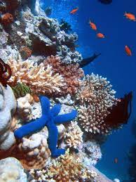
Each type of coral reef has its unique characteristics, and they play a vital role in supporting marine biodiversity and protecting coastal areas from erosion and storm surges. However, coral reefs worldwide are facing significant threats due to climate change, ocean acidification, pollution, and human activities. Conservation efforts are crucial to protect these delicate and vital ecosystems.
(d) Limit to growth
(a) Causes of Migration: Migration refers to the movement of individuals or groups from one place to another, typically involving a change in their residence. Several factors can trigger migration:
- Economic Reasons: Economic factors, such as better job opportunities, higher wages, and improved living standards, often lead people to migrate from rural to urban areas or from less developed to more developed countries in search of economic prosperity.
- Social Reasons: Social factors, such as family reunification or marriage, can prompt people to move to be with their loved ones.
- Political Reasons: Political instability, persecution, or conflicts can force people to leave their homes and seek refuge or safety in other regions or countries.
- Environmental Reasons: Natural disasters, climate change, or environmental degradation can render certain areas uninhabitable, pushing people to move to more sustainable locations.
- Demographic Factors: Changes in population dynamics, such as high birth rates or population pressure, can lead to migration as people seek better opportunities or living conditions elsewhere.
- Educational and Career Goals: Students and professionals may migrate to access better educational institutions or job prospects in other regions or countries.
(b) Rostow’s Stages of Development: Rostow’s stages of development, proposed by economist Walt Rostow in the 1960s, is a theory that outlines the economic growth and modernization process of countries. The model suggests that nations progress through five distinct stages of development:
- Traditional Society: The first stage represents a traditional agrarian society with limited technological advancements and low levels of productivity. Most economic activities are based on agriculture.
- Pre-conditions for Take-off: In this stage, certain factors emerge that facilitate economic growth, such as improvements in infrastructure, education, and technological innovation.
- Take-off: The take-off stage marks the beginning of sustained economic growth and industrialization. The country experiences rapid growth in specific sectors, leading to the overall transformation of the economy.
- Drive to Maturity: During this stage, the economy diversifies and reaches a level of maturity. Industrialization expands, and the nation becomes more self-sustaining economically.
- Age of High Mass Consumption: In the final stage, the economy is characterized by high levels of mass consumption and a focus on services and technology.
(c) Primate City: A primate city is a term used in urban geography to describe a city that dominates and overshadows all other cities and urban centers in a country or region. It is significantly larger and more populous than any other city in the same country and often serves as the nation’s political, economic, cultural, and administrative hub.
Characteristics of a Primate City:
- Size: A primate city is usually the largest city in the country, with a population that is substantially greater than that of the next-largest city.
- Economic Power: It is the primary center of economic activities, housing major industries, financial institutions, and commercial ventures.
- Political Significance: The primate city is often the capital or a major political center, housing the country’s government institutions and administrative offices.
- Cultural and Educational Hub: The city serves as a cultural and educational center, attracting prominent universities, museums, theaters, and other cultural institutions.
Examples of Primate Cities:
- London in the United Kingdom
- Paris in France
- Mexico City in Mexico
- Bangkok in Thailand
- Buenos Aires in Argentina
(d) Limit to Growth: The “Limits to Growth” is a concept introduced in the 1972 report of the same name, published by the Club of Rome, an international think tank. The report was the result of a computer simulation conducted by researchers from the Massachusetts Institute of Technology (MIT). It aimed to analyze the long-term consequences of exponential growth in population, industrialization, pollution, food production, and resource consumption.
The key idea of “Limits to Growth” is that unrestricted exponential growth of the human population and consumption of finite resources will eventually lead to environmental, social, and economic constraints. The report explored various scenarios and highlighted the potential negative impacts of unchecked growth, including resource depletion, pollution, and ecological damage.
The concept of “Limits to Growth” emphasizes the need for sustainable development practices and responsible resource management to ensure the well-being of future generations and the health of the planet. It has been a significant influence on discussions about environmental conservation, ecological economics, and the importance of balancing human activities with the Earth’s carrying capacity.
6. Examine the contribution of geographers in the development of Behavioural Geography.
Ans: Behavioural Geography is a subfield of geography that emerged in the mid-20th century, focusing on the study of human behavior and decision-making in relation to the spatial environment. Geographers played a crucial role in the development of Behavioural Geography by applying social science methodologies and theories to understand human interactions with the physical world. Their contributions include:
- Quantitative Methods: Geographers utilized quantitative methods and statistical techniques to analyze spatial patterns of human behavior. By conducting surveys, interviews, and spatial analysis, they sought to understand how individuals and groups interact with their surroundings and make decisions.
- Cognitive Mapping: Geographers explored cognitive mapping, a technique used to study how individuals perceive, represent, and navigate their environment mentally. Cognitive maps help understand how people conceptualize space and use mental images for orientation and decision-making.
- Time Geography: Geographers, like Torsten Hägerstrand, introduced time geography, a theoretical framework that examines how individuals allocate their time and make decisions based on time-space constraints. This approach has been valuable in understanding human mobility and activity patterns.
- Behavioral Studies in Urban Planning: Geographers contributed to urban planning by analyzing how people use and interact with urban spaces. Their research helped inform the design of cities, neighborhoods, and public spaces to better suit human needs and behaviors.
- Environmental Psychology: Geographers collaborated with psychologists to explore the relationship between the environment and human behavior. This interdisciplinary approach has been essential in understanding how the physical environment impacts human well-being and behavior.
- Human Perception of Landscapes: Geographers studied the aesthetic preferences and emotional responses of individuals to different landscapes. They explored the factors influencing people’s perceptions and the impact of landscape characteristics on human behavior.
- Migration and Settlement Studies: Behavioural geographers contributed to the study of migration patterns and settlement preferences. They examined the factors influencing migration decisions and analyzed the process of adapting to new environments.
- Human-Environment Interaction: Geographers examined the complex interactions between humans and the environment. Their research focused on how human behavior influences and is influenced by environmental factors, leading to insights into sustainable development and conservation efforts.
- Place Attachment and Identity: Behavioural geographers explored the concept of place attachment and how individuals form emotional connections to specific locations. They investigated how such attachments influence behavior and decision-making related to place.
- GIS and Spatial Analysis: The application of Geographic Information Systems (GIS) and spatial analysis techniques has been instrumental in behavioral geography. These tools have facilitated the study of spatial patterns of behavior and decision-making at various scales.
In summary, geographers have made significant contributions to the development of Behavioural Geography by adopting social science methodologies, exploring human behavior in relation to the spatial environment, and highlighting the importance of considering human factors in geographical research and planning. Their interdisciplinary approaches have enriched the understanding of human-environment interactions and influenced policy-making and urban development practices.
7. Elucidate the theory of industrial location as proposed by David M. Smith. Give criticism.
Ans: David M. Smith, a British geographer, proposed the theory of industrial location in the mid-20th century. His theory aimed to explain the spatial distribution of industries based on a combination of economic, geographical, and social factors. The theory considers the role of transportation costs, labor supply, raw material availability, market access, and regional policies in influencing industrial location decisions. Here are the key elements of Smith’s theory of industrial location:
- Transportation Costs: Smith emphasized the importance of transportation costs in determining industrial location. Industries tend to locate closer to raw materials and markets to reduce transportation expenses. This concept is known as the principle of minimum transport costs.
- Labor Supply: The availability and cost of labor are significant determinants of industrial location. Industries often locate in areas with a skilled and abundant labor force to optimize production efficiency.
- Agglomeration Economies: Smith recognized the benefits of clustering industries together, known as agglomeration economies. Concentration of industries in specific regions can lead to lower production costs through shared infrastructure, specialized suppliers, and skilled labor availability.
- Raw Material Availability: Access to essential raw materials influences the choice of industrial location. Industries reliant on specific inputs may locate near the source of these resources to minimize production costs.
- Market Access: Proximity to markets plays a vital role in industrial location decisions. Industries often prefer to be close to their customers to reduce distribution costs and respond quickly to demand fluctuations.
- Regional Policies: Government policies and incentives can significantly influence industrial location decisions. Governments may offer tax breaks, subsidies, or infrastructure development to attract industries to specific regions.
Criticism of Smith’s Theory of Industrial Location:
- Overemphasis on Transport Costs: Critics argue that Smith’s theory places excessive emphasis on transportation costs as the primary determinant of industrial location. While transportation is essential, other factors such as skilled labor, access to technology, and government policies also significantly influence industrial decisions.
- Neglect of Social Factors: Smith’s theory focuses primarily on economic and geographical factors, neglecting the role of social and cultural aspects in industrial location decisions. Social factors, such as quality of life, amenities, and local communities, can be important considerations for firms and workers.
- Homogeneity of Firms: The theory assumes that all firms within an industry are homogeneous and have the same location preferences. In reality, firms may have unique characteristics and considerations that influence their choice of location.
- Changing Technological Landscape: The rise of digital technology and e-commerce has altered traditional industrial location factors. With the growth of online markets, some industries may prioritize access to the internet and digital infrastructure over physical proximity to customers.
- Globalization: In the era of globalization, industries increasingly consider international factors, such as international trade agreements, access to global markets, and global supply chains, which may override traditional location factors.
In conclusion, David M. Smith’s theory of industrial location provides valuable insights into the factors influencing industrial location decisions. However, critics argue that the theory’s focus on transportation costs and its neglect of social and technological factors limit its applicability in the contemporary industrial landscape. The dynamics of industrial location continue to evolve, driven by advances in technology, globalization, and changing market demands.
8. What is a region ? Classify regions stating the bases of their classification.
Ans: In geography, a region refers to an area on the Earth’s surface with distinctive and common characteristics that set it apart from surrounding areas. Regions are defined based on various criteria, and they help geographers and other researchers understand the spatial patterns and characteristics of different parts of the world. Regions can vary in size, ranging from local to global scales. The classification of regions is primarily based on specific criteria or bases. Some common bases of classification are as follows:
- Administrative Regions:
- Political Regions: Countries, states, provinces, and administrative divisions are examples of political regions defined by governments for governance and administrative purposes.
- Local Government Areas: Municipalities, cities, towns, and villages are administrative regions designated for local governance.
- Physical Regions:
- Landform Regions: Areas characterized by specific landforms such as mountains, plateaus, plains, valleys, and deserts.
- Climate Regions: Regions with distinct climate patterns, such as tropical, temperate, arid, and polar climates.
- Vegetation Regions: Areas with specific vegetation types, such as forests, grasslands, tundra, and savannas.
- Cultural Regions:
- Linguistic Regions: Areas where people speak a common language or share similar linguistic characteristics.
- Religious Regions: Areas with a predominant religious belief or where a specific religion has a significant influence on the culture and society.
- Ethnic Regions: Areas where people of a specific ethnic group or cultural heritage are concentrated.
- Economic Regions:
- Industrial Regions: Areas with a concentration of industrial activities, factories, and manufacturing plants.
- Agricultural Regions: Areas with predominant agricultural activities, such as farming, ranching, or plantation agriculture.
- Trade and Commercial Regions: Areas that serve as major trade hubs or commercial centers, facilitating economic exchanges.
- Functional Regions:
- Nodal Regions: Areas surrounding a central point or node where there is a specific function or activity. For example, the area served by a major airport or a seaport.
- Economic Regions: Regions defined by patterns of economic interaction and interdependence. For instance, a labor market area or a commuting zone.
- Biogeographic Regions:
- Terrestrial Biomes: Large ecological regions characterized by specific vegetation types and climate conditions, such as forests, grasslands, and deserts.
- Aquatic Biomes: Large ecological regions in aquatic environments, including freshwater and marine biomes.
- Perceptual or Vernacular Regions:
- Perceived Regions: Regions based on people’s perceptions or mental maps, influenced by cultural, social, and historical factors.
- Vernacular Regions: Regions with informal boundaries, often based on common knowledge, stereotypes, or folklore.
It is important to note that regions are not always well-defined or mutually exclusive. They can overlap and change over time, depending on various factors and perspectives. The classification of regions helps geographers and other researchers organize and understand the complexities of the Earth’s diverse landscapes and human activities.
Read: OPSC Notes