India is a vast country characterized by remarkably diverse topography and landforms. The Physiographic Regions of India reflect a complex geological history, shaping climate, river systems, ecosystems, and human habitation patterns across the subcontinent.
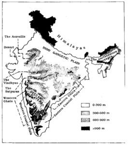
1. The Himalayan Region (The Northern Mountains)
Located in northern India, the Himalayas stretch from Jammu & Kashmir in the west to Arunachal Pradesh in the east. These young fold mountains were formed by the tectonic collision of the Indian and Eurasian plates and boast some of the highest peaks in the world, including Mount Everest and Kanchenjunga. They also serve as the source of major perennial river systems like the Indus, Ganges, and Brahmaputra.
- Key Features:
- Home to world-famous peaks like Mount Everest (Nepal) and Kanchenjunga.
- Divided into three parallel longitudinal ranges: Greater Himalayas (Himadri), Lesser Himalayas (Himachal), and Shiwaliks.
- Vital for climate regulation, glacier-fed water sources, and rich biodiversity.
2. The Indo-Gangetic Plain (The Northern Plains)
Lying south of the Himalayas, the Indo-Gangetic Plain is formed by extensive alluvial deposits from the Indus, Ganga, and Brahmaputra river systems and their tributaries. Characterized by a flat landscape, it is one of the most fertile and densely populated agricultural regions in the world.
- Key Features:
- Extremely fertile flat terrain, forming India's agricultural heartland.
- Densely populated due to fertile soils and perennial water availability.
- Subdivided into the Punjab Plains, Ganga Plains, and Brahmaputra Valley.
3. The Peninsular Plateau
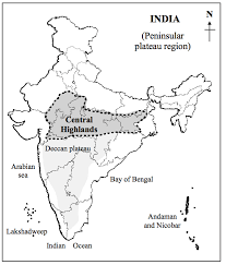
Covering central and southern India, the Peninsular Plateau is the oldest and most stable landmass of the subcontinent, composed primarily of igneous and metamorphic rocks. Rich in mineral resources, it is bordered by the Western and Eastern Ghats.
- Key Features:
- Broadly divided into the Central Highlands and the Deccan Plateau.
- Exceptionally rich in mineral and ore deposits.
- Drained by major east-flowing rivers such as the Godavari, Krishna, and Mahanadi.
4. The Western Ghats
The Western Ghats (Sahyadri) run parallel to the western coast of India. Characterized by steep escarpments, dense tropical forests, and numerous waterfalls, they give rise to important rivers like the Godavari, Krishna, and Kaveri.
5. The Eastern Ghats
The Eastern Ghats run along India's eastern coast. Unlike the continuous Western Ghats, they comprise a series of discontinuous, lower hills and plateaus, traversed by major eastward-flowing rivers like the Godavari, Mahanadi, and Krishna.
6. The Thar Desert (The Great Indian Desert)
Located primarily in western Rajasthan, the Thar Desert is a vast arid region featuring shifting sand dunes, extreme temperatures, and low annual rainfall.
- Key Features:
- Sparse vegetation and low population density.
- Supports a vibrant camel-based economy, solar energy installations, and rich cultural heritage.
- The Luni river is the only major seasonal river in the region.
7. The Coastal Plains
Flanking the Peninsular Plateau along the Arabian Sea and the Bay of Bengal, India's coastal plains include the Konkan Coast, Malabar Coast, Coromandel Coast, and the Andhra Coast. These flat, fertile lowlands host major ports, commercial centers, and dense coastal populations.
Conclusion
India's physiographic regions are a stunning testament to the country's rich geological and ecological diversity. Understanding these distinct landforms provides a profound appreciation for India's natural beauty, climate systems, and economic development.