The Bottom Topography of the Pacific Ocean refers to the physical features and geological structures present on the ocean floor. These features result from tectonic movements, volcanic activity, sedimentation, and erosion over millions of years. It's the underwater landscape, much like the mountains, valleys, plains, and trenches we see on land, but hidden beneath miles of water.
Introduction to Pacific Ocean
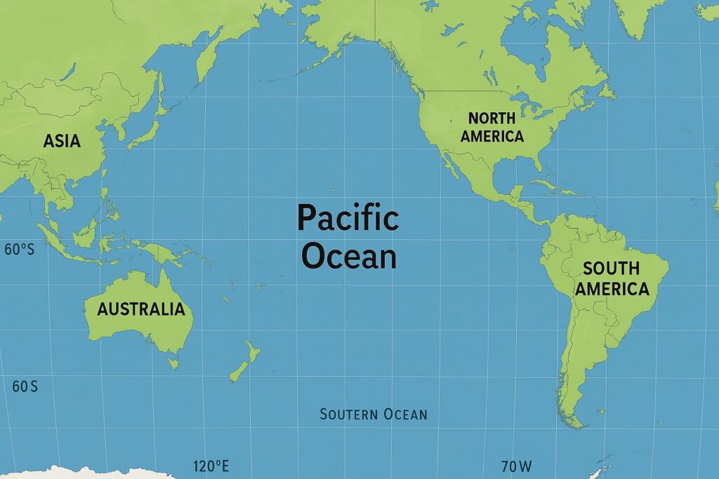
The Pacific Ocean is the largest and deepest ocean on Earth, covering over 60 million square miles and reaching depths of over 36,000 feet in some places. In this article, we will discuss the Bottom Topography of the Pacific Ocean.
The ocean floor of the Pacific is just as diverse and complex as its surface and includes a wide range of underwater features that play important roles in everything from ocean currents and weather patterns to the distribution of marine life and the location of mineral and energy resources.
Meaning of Bottom Topography
Bottom topography refers to the physical features and variations in elevation found on the ocean floor, such as trenches, ridges, seamounts, abyssal plains, and guyots. It is essentially the "landscape" beneath the sea, shaped by geological processes like plate tectonics, volcanic activity, and sediment deposition. Studying bottom topography helps scientists understand the structure of the Earth's crust, predict tectonic movements, explore marine resources, and improve navigation and oceanographic research.
Division of Pacific Ocean
The Pacific Ocean is broadly divided into four sub-regions:
- The North Pacific Ocean lies north of the equator, bordered by eastern Asia to the west and North America to the east, and includes seas like the Bering Sea and Sea of Japan.
- The South Pacific Ocean lies south of the equator, stretching between Australia and South America, and is home to numerous island nations such as Fiji and Tonga.
- The Eastern Pacific Ocean runs along the western coasts of North and South America and features major geological structures like the Peru-Chile Trench; it is also significantly influenced by oceanic phenomena such as El Niño.
- The Western Pacific Ocean borders the eastern coasts of Asia and Australia, is highly tectonically active, and includes some of the world’s deepest trenches and important seas such as the South China Sea and Coral Sea.
Features of Bottom Topography of Pacific Ocean
The continental shelf of the Pacific Ocean is the submerged extension of continental landmasses that slopes gently before dropping into the deep ocean. It serves as a critical zone for marine ecosystems, economic activities, and geological processes.
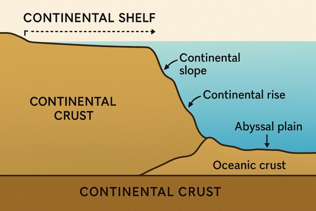
- The Pacific Ocean’s continental shelves are most extensive along the western Pacific, near Asia and Australia, while relatively narrow along the eastern Pacific, near North and South America.
- The shelf extends from the shoreline to depths of around 200 meters (656 feet) before transitioning into the continental slope.
- Bering Sea Shelf – One of the largest and widest continental shelves, located off Alaska and extending into Russian waters.
- East China Sea Shelf – A broad shelf influenced by sediment inflow from the Yangtze River, rich in marine biodiversity.
- Australian Shelf – Located off the northern and eastern coast of Australia, supporting diverse coral reef systems, including the Great Barrier Reef.
- Peruvian and Chilean Shelves – Comparatively narrow due to active subduction zones that lead to steep ocean floor transitions.
- Formed by sediments deposited over millions of years, including sand, silt, and organic material.
- Contains significant oil, gas, and mineral deposits, and supports rich fisheries and marine biodiversity.
- The continental slope is the steep slope between the continental shelf and the deep ocean floor.
- In the Pacific Ocean, the slope is often narrow and steep, especially along active margins like the coasts of North and South America and East Asia.
- Due to tectonic activity, especially subduction zones, the slope in the Pacific is more dramatic compared to the Atlantic.
- Features like submarine canyons are common, formed by underwater erosion and sediment transport.
- The continental rise lies beyond the continental slope and is characterized by a gentler gradient.
- It is formed by the accumulation of sediments that cascade down the slope through turbidity currents.
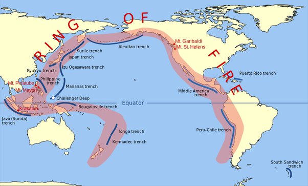
- In the Pacific Ocean, the continental rise is less developed or even absent in many regions with active margins (like the "Ring of Fire") because trenches replace the rise.
- However, in regions with passive margins, such as parts of the western Pacific near Australia, a more defined rise can be observed.
Abyssal plains are vast, flat, and deep areas of the ocean floor found at depths of 3,000 to 6,000 meters, covered by fine-grained sediments like clay and microscopic marine organisms.
- The Pacific Ocean has fewer and less extensive abyssal plains compared to the Atlantic because much of the Pacific has tectonically active margins with deep oceanic trenches.
- Notable abyssal plains include the Clarion-Clipperton Zone, Peru Basin, and Nauru Basin.
- Abyssal plains in the Pacific are often interrupted by seamounts, guyots, and fracture zones.
- They accumulate sediment over time and contain valuable minerals like manganese nodules, providing crucial habitats for deep-sea life and aiding in oceanic carbon cycling.
This ridge runs along the eastern side of the Pacific and is an active divergent boundary where tectonic plates—such as the Pacific Plate and the Nazca Plate—are spreading apart, allowing magma to rise and create new oceanic crust. Unlike the Mid-Atlantic Ridge, the East Pacific Rise is characterized by fast-spreading rates, leading to a relatively smooth topography.
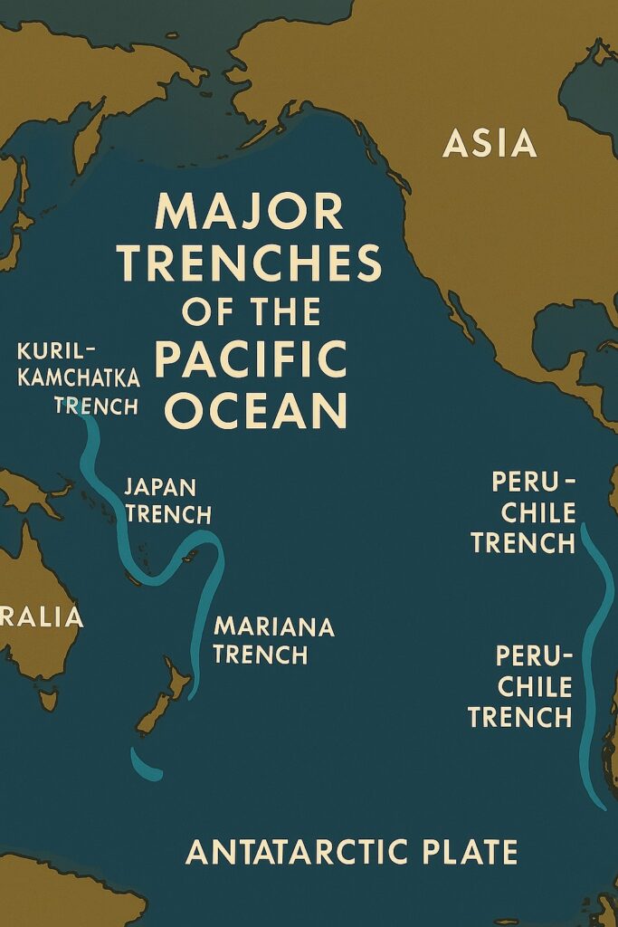
Oceanic trenches are the deepest parts of the ocean floor, formed by subduction. The Pacific Ocean is home to the majority of the world’s oceanic trenches:
- Mariana Trench: Deepest ocean trench in the world (approx. 11,034 meters deep), located east of the Mariana Islands.
- Peru-Chile Trench (Atacama Trench): Runs along the west coast of South America where the Nazca Plate subducts beneath the South American Plate.
- Philippine Trench: East of the Philippines, formed by the subduction of the Philippine Sea Plate.
- Tonga Trench: Located in the South Pacific near Tonga and New Zealand.
- Kuril and Japan Trenches: Located off the coasts of Japan and Russia, sites of frequent seismic activity.
- Kermadec Trench: North of New Zealand, continuation of the Tonga Trench.
The oceanic plateaus in the Pacific Ocean include the Shatsky Rise and the Ontong Java Plateau. These are large underwater massifs rising several thousand meters above the abyssal plain, formed by intense volcanic activity and tectonic movement.
- Shatsky Rise: Located in the northwestern Pacific, formed by hotspot volcanic activity.
- Ontong Java Plateau: Located in the western Pacific, one of the largest oceanic plateaus in the world, characterized by seamounts and volcanic ridges.
Importance of Bottom Topography of Pacific Ocean
The bottom topography of the Pacific Ocean is important for a variety of scientific, economic, and strategic reasons. For example, the ocean floor is home to a wide range of valuable mineral resources, including manganese nodules, hydrothermal vents, and other minerals critical to modern industry and technology. In addition, the ocean floor plays a key role in the Earth's climate system, influencing the distribution of ocean currents, heat storage, and carbon dioxide exchange between the atmosphere and the ocean.
Conclusion
The bottom topography of the Pacific Ocean showcases a complex interplay of tectonic subduction, rapid seafloor spreading, massive trenches, and volcanic plateaus, making it the most dynamic and geologically active oceanic basin on Earth.