The study of regional synthesis is a crucial aspect in understanding how the physical and human systems interact to shape the landscape. It involves the examination of the complex interplay between physical and human processes and the resulting landscape patterns.
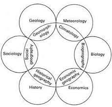
Table of Contents
What is Regional Synthesis?
It is a process of combining various pieces of information and data to form a comprehensive picture of a particular region. This information can be physical, such as geology and climate, or human-related, such as economic activity and demographics. Regional synthesis allows geographers to study the interactions between these physical and human systems and to understand the resulting landscape patterns.
Who Propounded the Concept?
The concept was first proposed by the American geographer, Nevin M. Fenneman. In his 1916 book “Physiography of Western United States”, Fenneman argued that geography was not simply the study of individual features such as mountains and rivers, but rather a holistic study of the physical and human characteristics of a region.
Fenneman believed that a region’s physical features, climate, and vegetation were all interconnected and influenced by one another, and that understanding these interrelationships was key to understanding a region’s unique characteristics. He also emphasized the importance of incorporating human factors such as culture, economics, and politics into regional studies.
Why is Regional Synthesis Important?
It is important for several reasons. Firstly, it helps geographers to understand the complexity of the earth’s surface and the various factors that contribute to the diversity of landscapes. Secondly, it provides a useful tool for regional planning and decision-making by allowing planners and policy makers to understand the interplay between physical and human systems. Thirdly, it is a useful tool for comparative studies between regions, allowing geographers to identify common trends and patterns and to make meaningful comparisons between areas.
Applications
It has a wide range of applications in geography and other related fields. Some of the most notable applications include:
- Environmental Management: Regional synthesis is important in environmental management, as it helps to understand the interactions between physical and human systems and the impact of human activities on the environment. This information can be used to make informed decisions about land use, conservation, and resource management.
- Urban Planning: In urban planning, regional synthesis is used to study the interactions between physical and human systems in urban areas and to understand the patterns of land use and urban growth.
- Economic Geography: Regional synthesis is also important in economic geography, as it helps geographers to understand the interplay between economic activity and physical factors, such as access to transportation and natural resources.
- Political Geography: In political geography, regional synthesis is used to study the interactions between political systems and physical factors, such as borders and territorial boundaries.
In conclusion, regional synthesis is a crucial aspect of geography that enables geographers to understand the interactions between physical and human systems and the resulting landscape patterns. With its wide range of applications, it provides a useful tool for environmental management, urban planning, economic analysis, and political analysis. By combining various pieces of information and data, regional synthesis allows us to gain a comprehensive understanding of the earth’s surface and to make informed decisions about its use and management.
Read: Geography Notes