Geography
- Paper Time: 3 hours
- Full Marks : 300
- The figures in the right-hand margin indicate marks.
- Candidates should attempt Q. No. 1 from Section-A and Q. No. 5 from Section B which are compulsory and any three of the remaining questions, selecting at least one from each Section.
SECTION-A
1. Mark the correct location of the following on the map given to you and write the most significant points of each in not more than 10 words:
6×10 60
(a) River Nile
(b) Swaraj Dweep
(c) Sunderbans
(d) Aravallis
(e) Palk bay
(f) Prairies
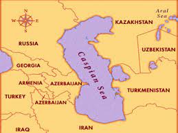
(g) Caspian sea
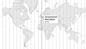
(h) Greenwich
(i) Suez canal
(j) Equatorial counter current
2. Discuss the concept of the cycle of erosion as propounded by W. M. Davis. 60
3. What are the basic requirements for the development of a tropical cyclone ? Describe weather sequence of an approaching tropical cyclone. Why do they dissipate over the land ? 60
4. What are coral reefs ? State the favorable conditions necessary for the growth and development of corals. Explain the nature and mode of occurrences of different types of coral reefs with suitable illustrations. 60
SECTION-B
5. Answer any three of the following: 60
(a) Causes of migration
(6) Rostow’s stages of development
(c) Primate city
(d) Limit to growth
6. Examine the contribution of geographers in the development of Behavioural Geography. 60
7. Elucidate the theory of industrial location as proposed by David M. Smith. Give criticism. 60
8. What is a region ? Classify regions stating the bases of their classification. 60
SOLUTION
1. Mark the correct location of the following on the map given to you and write the most significant points of each in not more than 10 words:
6×10 60
(a) River Nile
(b) Swaraj Dweep
(c) Sunderbans
(d) Aravallis
(e) Palk bay
(f) Prairies
(g) Caspian sea
(h) Greenwich
(i) Suez canal
(j) Equatorial counter current
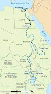
(a) River Nile: The River Nile is a major north-flowing river in northeastern Africa. It is the longest river in the world. It flows through multiple countries, including Egypt, Sudan, Ethiopia, Uganda, and others. The Nile has played a crucial role in the development of ancient civilizations, providing water for irrigation and fertile lands for agriculture along its banks.
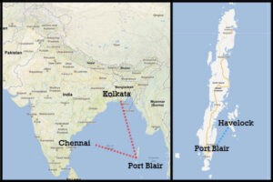
(b) Swaraj Dweep: Swaraj Dweep is a beautiful island situated in the Andaman and Nicobar archipelago of India. It is a popular tourist destination. It is also called Havelock Island.
(c) Sunderbans: The Sunderbans is a vast mangrove forest located in the delta region of the Ganges, Brahmaputra, and Meghna rivers in India and Bangladesh. It is a UNESCO World Heritage Site and home to the iconic Bengal tiger. The Sunderbans is known for its unique biodiversity, with numerous plant and animal species adapted to the brackish water ecosystem.

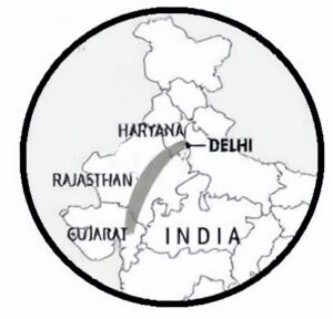
(d) Aravallis: The Aravalli Range is a mountain range in northwestern India, stretching across the states of Gujarat, Rajasthan, Haryana, and Delhi. It is one of the oldest mountain ranges in the world and serves as a prominent geographical feature of the Indian subcontinent. The Aravallis are ecologically significant, providing a habitat for diverse flora and fauna.
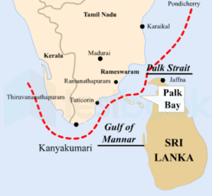
(e) Palk Bay: Palk Bay is a shallow water body located between the southeastern coast of India (Tamil Nadu) and the northern coast of Sri Lanka. It is a part of the Bay of Bengal and serves as a crucial fishing zone for both countries. The region is known for its marine biodiversity and is an important migratory route for marine species.
(f) Prairies: Prairies are vast, flat grasslands characterized by fertile soils and temperate climates. They are found in various parts of the world, including North America, Eurasia, and South America. The North American Prairies, also known as the Great Plains, stretch across the central United States and Canada and are known for their agricultural importance.

(g) Caspian Sea: The Caspian Sea is a large, enclosed inland body of water located between Europe and Asia. It is the world’s largest inland body of water by both surface area and volume. The Caspian Sea is bordered by five countries: Russia, Kazakhstan, Turkmenistan, Iran, and Azerbaijan. It is rich in oil and gas reserves and plays a significant role in regional trade and transportation.
(h) Greenwich: Greenwich is a district in London, United Kingdom, known for its historical and cultural significance. It is the location of the Prime Meridian (0 degrees longitude) and the Greenwich Observatory, which has been a center for astronomical observations since the 17th century. The Prime Meridian is used as the reference for measuring time zones around the world.
(i) Suez Canal: The Suez Canal is an artificial waterway that connects the Mediterranean Sea to the Red Sea, allowing ships to navigate between Europe and Asia without the need for a lengthy and hazardous trip around the southern tip of Africa. It is a critical trade route, facilitating the transportation of goods between the East and the West.

(j) Equatorial Counter Current: The Equatorial Counter Current is an oceanic current that flows eastward along the equator, opposing the westward-flowing equatorial currents. It is present in both the Atlantic and the Pacific Oceans. The Equatorial Counter Current plays a crucial role in the Earth’s climate system and the redistribution of heat and energy.

2. Discuss in detail the concept of the cycle of erosion as propounded by W. M. Davis. (60)
Ans: The concept of the cycle of erosion, also known as the geographical cycle or Davisian cycle, was proposed by the American geographer William Morris Davis in the late 19th and early 20th centuries. Davis is considered one of the founding figures of geomorphology, the study of landforms and the processes that shape them. The cycle of erosion is a theoretical model that describes the long-term evolution of landforms through the continuous interplay of various geomorphic processes.
Key Concepts of the Cycle of Erosion:
- Equilibrium Model: Davis proposed that landscapes tend to move towards a state of dynamic equilibrium over time. This means that landforms adjust themselves to achieve a balance between the uplift of new rocks and the processes of erosion that wear them down.
- Stages of Development: According to Davis, the cycle of erosion consists of several stages through which a landscape evolves. These stages include youth, maturity, and old age. Each stage represents a different level of topographic development and is characterized by specific landforms.
- Gradual Evolution: Davis emphasized the gradual nature of landscape evolution. Landforms change over geological time through a series of slow and continuous processes, such as weathering, erosion, and sedimentation.
- Concept of Peneplanation: One of the key ideas in Davis’s cycle of erosion is the concept of peneplanation. Peneplanation refers to the hypothetical reduction of an entire landscape to a featureless plain by continuous erosion. According to Davis, landscapes tend to progress towards peneplanation over time.
Stages of the Cycle of Erosion:
- Youth Stage: The youth stage is characterized by high relief and steep slopes. The landscape is dominated by processes such as fluvial erosion, glaciation, or tectonic uplift, which create deep valleys, rugged mountains, and other sharp landforms. The drainage pattern is typically immature, with narrow, V-shaped valleys.
- Maturity Stage: As the landscape undergoes further erosion, the maturity stage sets in. During this stage, the relief becomes less steep as the forces of erosion continue to wear down the landforms. River valleys widen, and the landscape takes on a more subdued appearance. The drainage pattern becomes more integrated, forming meandering rivers and broader valleys.
- Old Age Stage: In the old age stage, the landscape approaches a state of relative flatness, and the landforms become more subdued. The landscape achieves a state of greater equilibrium, and the erosion processes tend to match the uplift rates. The rivers exhibit a more dendritic (tree-like) drainage pattern, and the landforms are characterized by broad plains and low-relief features.
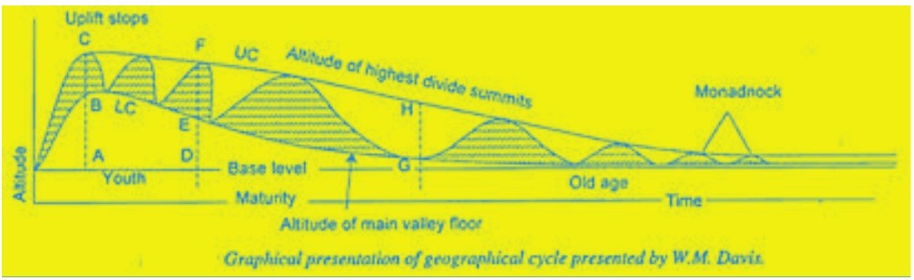
Criticisms and Limitations:
While the cycle of erosion proposed by Davis was groundbreaking and influential, it has also faced criticism and has been subject to modifications and refinements by subsequent geomorphologists. Some of the criticisms and limitations of the Davisian cycle include:
- Simplification: The cycle of erosion is a simplified model that does not consider the complexities and variations that can occur in different landscapes.
- Time Scale: The cycle operates over long geological time scales, making it challenging to directly observe the entire cycle in action.
- Human Impact: The cycle of erosion does not take into account the significant impact of human activities on landscapes, such as deforestation, urbanization, and agriculture.
- Equilibrium Assumption: The assumption of a dynamic equilibrium has been criticized, as landscapes are subject to continual changes due to tectonic activity and climatic shifts.
Conclusion:
Despite its limitations, William Morris Davis’s cycle of erosion remains a significant contribution to the understanding of landscape evolution. It provided a conceptual framework for examining how landscapes change over time through the interactions of geological processes. While modern geomorphology has advanced significantly since Davis’s time, the cycle of erosion laid the foundation for further research and continues to be a fundamental concept in the study of landforms and landscape dynamics.