Geography Optional Question Paper-2 (2022)
SECTION A
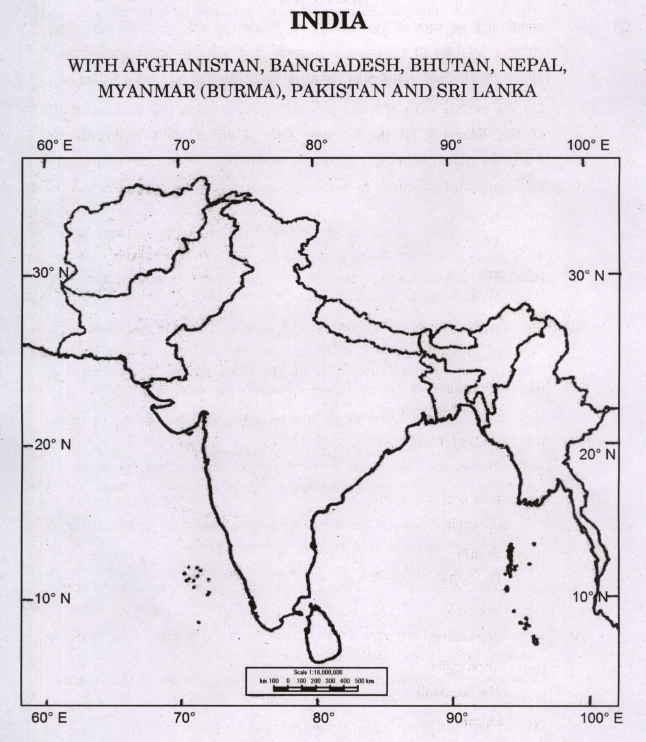
Q1. (a) On the outline map of India provided to you, mark the location of all of the following. Write in your QCA Booklet the significance of these locations, whether physical / commercial / economic / ecological / environmental / cultural, in no more than 30 words for each entry : 2×10 = 20
(i) Tarangambadi
(ii) Mahe
(iii) Bomdila
(iv) Dhola Sadiya Bridge
(v) Talakaveri
(vi) Satkosia
(vii) Dholavira
(viii) Sonamarg
(ix) Maliku Atoll
(x) Gangasagar
(b) Why has extreme particulate pollution remained a festering issue in Delhi NCR region ? (10)
(c) How do physiography and climate of India explain the biological diversity of the country ? (10)
(d) The process of desertification. leads to soil desiccation and soil loss. Explain. (10)
Q2. (a) Critically examine the factors affecting the unpredictability of South-West Monsoon system in India. (20)
(b) The peninsular location of India provides scope for harnessing non-conventional energy resources. Discuss with examples. (15)
(c) Groundwater contamination in the fast expanding urban landscape of India appears to have become a major public health issue. Discuss. (15)
Q3. (a) Discuss the recent changes brought about in institutional frameworks of agriculture in India. Evaluate its impact on the agrarian economy of the country. (20)
(b) Discuss the continuing disputes on water sharing between the riparian states of North-West India. (15)
(c) Soils of India, are clear reflections of the structure and process. Comment. (15)
Q4. (a) India is bestowed with rich mineral resources due to its geological structure. Correlate the above statement with large mineral belts of India. (20)
(b) Discuss the importance of ‘Dry-land’ farming in the drought-prone regions of India. (15)
(c) Incidence of extreme rainfall events and flash floods in recent times have led to devastating consequences for people living in low-lying areas and flood plains of the country. Discuss. (15)
SECTION B
Q5. Answer the following questions in about 150 words each : 10×5=50
(a) Discuss the impact of Forest Rights Act, 2006 on the local forest communities in India.
(b) Can the Panchayat Raj institutions play a role in grass root level planning in India ? If yes, discuss how.
(c) Discuss the significance of new ports on the Western Coast of India on the external trade of the country.
(d) How would decline in Total Fertility Rate (TFR) below the replacement level, in many states of India affect the future population structure of the country ?
(e) Kalapani dispute has opened a new front on the India-Nepal international border. Explain.
Q6. (a) Why do disparities in development and incomes between regions persist in large countries like India ? How does the recent ADP plan address the issue?
(b) Critically examine the role of IRNSS-NavIC programme on the satellite navigation system of India.
(c) Examine the role of high population concentration in Indian slums in making them more vulnerable during pandemic conditions like the COVID-19.
Q7. (a) Discuss the salient characteristics of industrial complexes of Western India. Examine the impact of SEZ policy on the region.
(b) Discuss the emergence of linguistic regions and states in India.
(c) What are the drivers of urban sprawl around the major cities of the country? How have new investments in transport projects supported sprawl development ?
Q8. (a) How do agro-climatic and land capability indicators assist in macro-agricultural regionalisation of India? Illustrate with an appropriate map.
(b) Discuss the geopolitical significance of Quad in the Indo-Pacific realm with reference to marine trade in the region.
(c) Evaluate the role of the National Food Security Act, 2013 in providing access of food to the poor in India.
SOLUTION
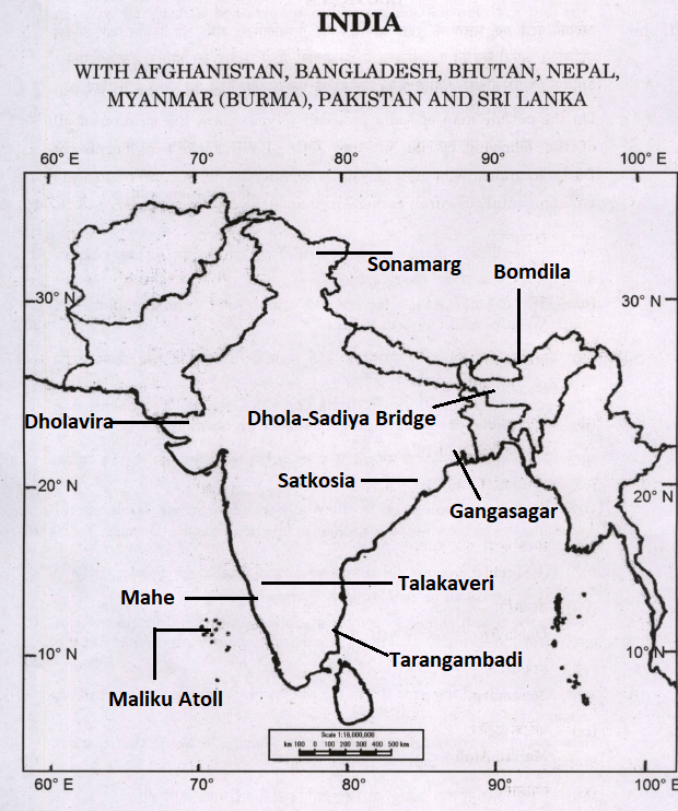
1. (a) (i) Tarangambadi: It is a historic coastal town in Tamil Nadu, with significant Danish colonial heritage. Established in 1620 by Danish traders, it became a prominent Danish settlement. The town’s cultural heritage showcases a blend of Danish, Tamil, and Indian influences, evident in landmarks like the New Jerusalem Church, one of India’s oldest Protestant churches.
(ii) Mahe: It is a town located in Union Territory of Puducherry. It is situated on the west coast of Kerala, surrounded by the state of Kerala on three sides and the Arabian Sea on the fourth side. Mahe was a French colonial enclave during the colonial period and was part of French India until it was integrated into the Indian Union in 1956.
(iii) Bomdila: It is a town located in the West Kameng district of Arunachal Pradesh. The town is home to the Buddhist monastery of Bomdila.
(iv) Dhola-Sadiya Bridge: It is also known as the Bhupen Hazarika Setu, is a road bridge that spans across the Brahmaputra River in the northeastern state of Assam, India. It connects the regions of Dhola in the state of Assam to Sadiya in the state of Arunachal Pradesh. The bridge was inaugurated in May 2017 and is one of the longest bridges in India.
(v) Talakaveri: It is a significant pilgrimage site and the origin of the Kaveri River, one of the major rivers in southern India. It is located in the Brahmagiri hills in the Kodagu (Coorg) district of the state of Karnataka.
(vi) Satkosia: It is a tiger reserve located on Odisha. It has remarkable geographical features shaped by the dynamic forces of the Mahanadi River.
(vii) Dholavira: It is an ancient archaeological site located in the Kutch district of the state of Gujarat. It is one of the five largest and most important Harappan (Indus Valley Civilization) sites, dating back over 4,500 years. This historical site offers valuable insights into the urban planning, architecture, and advanced civilization that thrived in the region during the Bronze Age.
(viii) Sonamarg: It situated in the Ganderbal district of Jammu and Kashmir. The meandering Sindh River flowing through the valley enhances the scenic beauty of this “Meadow of Gold.”
(ix) Maliku Atoll: It is also known as Addu Atoll. It is a group of islands located in the southernmost part of the Maldives in the Indian Ocean. It is one of the largest natural atolls in the world and is known for its unique geographical features and diverse marine life. The atoll is made up of several small islands and coral reefs. Maliku Atoll has a rich history and was once an important British naval base during World War II.
(x) Gangasagar: It is also known as Sagar Island. It is a sacred island located in the Ganges Delta in the Indian state of West Bengal. Situated at the confluence of the Ganges River (Ganga) and the Bay of Bengal, Gangasagar is a significant pilgrimage site for Hindus. The island holds immense religious importance, as it is believed that taking a holy dip at the confluence of the Ganges and the sea can wash away one’s sins.
(b) Why has extreme particulate pollution remained a festering issue in Delhi NCR region ? (10)
Ans: Extreme particulate pollution has remained a festering issue in the Delhi National Capital Region (NCR) due to a combination of factors, including geographical, meteorological, and anthropogenic influences.
- Geographical Factors: Delhi’s geographical location in a basin surrounded by the Aravalli Hills to the south and the Himalayas to the north creates a condition known as “thermal inversion.” During winter months, cold air gets trapped near the surface, preventing the upward dispersion of pollutants, including particulate matter. This inversion layer traps pollutants, leading to a build-up of particulate matter in the atmosphere.
- Meteorological Factors: Weather conditions, such as low wind speeds and high humidity during certain periods, exacerbate the problem. Low wind speeds limit the dispersion of pollutants, while high humidity contributes to the formation of secondary particulate matter, such as sulfate and nitrate particles.
- Vehicular Emissions: The rapid increase in vehicular traffic in Delhi NCR is a major contributor to particulate pollution. Diesel-powered vehicles, especially trucks and buses, emit significant amounts of particulate matter, black carbon, and nitrogen oxides, further worsening air quality.
- Industrial Activities: Delhi NCR is home to various industries, and their emissions contribute to the high levels of particulate matter in the region. The use of outdated technologies and inadequate pollution control measures in some industries exacerbates the problem.
- Construction and Dust: Construction activities and the presence of large amounts of dust due to road dust re-suspension contribute significantly to particulate pollution, especially during dry and windy days.
- Biomass Burning: The burning of agricultural waste, crop residues, and solid waste contributes to particulate pollution, especially during the post-harvest season.
- Population Density: The high population density in Delhi NCR results in increased energy consumption, transportation demands, and waste generation, all of which contribute to particulate pollution.
Addressing the extreme particulate pollution in Delhi NCR requires a comprehensive approach, including strict emission norms for vehicles and industries, improved public transportation, promotion of clean energy sources, better waste management practices, and measures to reduce crop residue burning. Additionally, regional cooperation among neighboring states and long-term planning are essential to effectively combat the issue of particulate pollution in the Delhi NCR region.
(c) How do physiography and climate of India explain the biological diversity of the country ? (10)
Ans: The physiography and climate of India play a crucial role in explaining the country’s rich biological diversity. India’s diverse landscapes, from the lofty Himalayas in the north to the vast coastal plains in the south, along with its varied climatic zones, create a wide range of habitats that support diverse ecosystems and species.
- Geographical Features: India’s geographical features, such as mountains, plains, plateaus, and coastal areas, create distinct habitats for various plants and animals. The Himalayas, with their varying altitudes and climatic zones, support a range of flora and fauna, from temperate forests in the lower regions to alpine vegetation at higher elevations. The Western Ghats and the Eastern Ghats, along with their associated hill ranges, provide unique ecosystems with high biodiversity due to their isolation and distinct microclimates.
- Climate Zones: India experiences a diverse range of climates, from tropical in the south to temperate and cold in the north. The monsoon season, which brings heavy rainfall, is a significant climatic factor that influences the distribution of vegetation and wildlife across the country. The combination of wet and dry seasons provides favorable conditions for a variety of plant species and supports the breeding and migration of various animal species.
- Biodiversity Hotspots: The combination of varied physiography and climates has led to the emergence of several biodiversity hotspots in India. These hotspots, such as the Western Ghats and the Eastern Himalayas, are regions of exceptionally high species richness and endemism. The presence of unique and specialized species in these hotspots is attributed to the specific ecological conditions found in these areas.
- Agro-climatic Diversity: India’s diverse climate zones support a wide range of agricultural practices and crop varieties. Different regions specialize in growing specific crops, leading to agro-climatic diversity. This diversity extends to traditional agricultural practices and indigenous crop varieties, which contribute to India’s agricultural biodiversity.
- Aquatic Biodiversity: India’s extensive coastline and inland water bodies, such as rivers, lakes, and wetlands, support a rich aquatic biodiversity. The coastal regions are home to diverse marine species, while inland water bodies provide habitats for a variety of freshwater fish and aquatic plants.
In summary, India’s biological diversity is a result of the interaction between its physiography and climate, which create diverse habitats and ecological niches for a wide range of plant and animal species. This diversity has led to the evolution of unique ecosystems and species, making India one of the world’s biodiversity hotspots and an important center for conservation and research in the field of biodiversity and ecology.
(d) The process of desertification. leads to soil desiccation and soil loss. Explain. (10)
Ans: Desertification is the process by which fertile land becomes progressively more arid and degraded, transforming into desert-like conditions. This phenomenon is primarily caused by a combination of natural and human-induced factors, leading to soil desiccation and soil loss. Let’s explore the key aspects of this process:
- Climate Change: Climate plays a significant role in desertification. Prolonged droughts and changes in precipitation patterns lead to reduced water availability in the affected regions. As the land becomes drier, the soil loses moisture, leading to soil desiccation. Evaporation rates may exceed precipitation rates, causing the soil to become dry and devoid of moisture.
- Deforestation and Overgrazing: Human activities, such as deforestation and overgrazing by livestock, exacerbate desertification. Trees and vegetation act as natural barriers, protecting the soil from erosion and maintaining soil moisture. When trees are cut down, or grasslands are overgrazed, the protective cover is lost, exposing the soil to wind and water erosion, further contributing to soil desiccation and soil loss.
- Unsustainable Agricultural Practices: Unsustainable agricultural practices, such as monoculture farming, excessive irrigation, and improper land management, can deplete soil nutrients and lead to soil degradation. The excessive use of water for irrigation can lead to the accumulation of salts in the soil, a process known as salinization, which makes the soil infertile and unsuitable for agriculture.
- Soil Erosion: Desertification accelerates soil erosion. As vegetation cover decreases due to human activities or natural factors, the soil becomes vulnerable to erosion by wind and water. Wind erosion occurs when dry and loose soil particles are carried away by strong winds, while water erosion occurs when rainwater washes away the topsoil. This erosion further reduces soil fertility and contributes to soil loss.
- Compaction and Crusting: Desertification can lead to soil compaction and the formation of a hard crust on the soil surface. This compaction restricts the movement of air and water into the soil, hindering plant growth and contributing to soil desiccation.
As desertification progresses, the affected land becomes increasingly barren, leading to loss of biodiversity, reduced agricultural productivity, and social and economic challenges for the communities living in the affected regions. Addressing desertification requires sustainable land management practices, afforestation and reforestation efforts, and water conservation measures to restore and protect the soil and halt the process of soil desiccation and soil loss.
Q2. (a) Critically examine the factors affecting the unpredictability of South-West Monsoon system in India. (20)
Ans: The South-West Monsoon is a crucial weather phenomenon in India, responsible for a significant portion of the country’s annual rainfall. However, the monsoon system’s unpredictability is a major challenge for agriculture, water management, and overall economic planning. Several factors contribute to this unpredictability, and it is essential to critically examine them:
- El Nino and La Nina: These are climate phenomena that occur due to the warming and cooling of ocean waters in the Pacific Ocean. El Nino tends to suppress monsoon rains in India, leading to drought conditions, while La Nina enhances monsoon rainfall. The timing and intensity of these events can vary, leading to uncertainty in monsoon behavior.
- Indian Ocean Dipole (IOD): The Indian Ocean Dipole is another climate phenomenon that affects the South-West Monsoon. A positive IOD is associated with warmer waters in the western Indian Ocean and can lead to enhanced monsoon rainfall, while a negative IOD can result in reduced rainfall. The variability in the IOD and its impact on the monsoon are difficult to predict accurately.
- Madden-Julian Oscillation (MJO): The MJO is a tropical weather pattern that can influence the onset and progression of the monsoon. However, the MJO’s behavior is challenging to forecast, making it challenging to predict its impact on the monsoon system.
- Ocean-Atmosphere Coupling: The complex interactions between the ocean and the atmosphere in the Indian Ocean region influence the monsoon’s behavior. The coupling of the ocean and atmosphere in the Indian Ocean is highly dynamic and difficult to model accurately, leading to uncertainties in monsoon forecasts.
- Global Climate Change: Climate change is altering weather patterns worldwide, including the monsoon system in India. Rising global temperatures and changing atmospheric conditions can affect the monsoon’s timing, intensity, and distribution, making long-term predictions more challenging.
- Land-Atmosphere Interactions: Land use changes, deforestation, and urbanization can influence local weather patterns and alter the monsoon’s behavior. Human-induced modifications to the land surface can affect temperature, humidity, and wind patterns, leading to unpredictability in the monsoon system.
- Topography: The diverse topography of India, with its mountain ranges and coastal regions, influences the monsoon’s behavior. The presence of mountains can affect the monsoon winds, leading to variations in rainfall patterns across different regions of the country.
- Complex Weather Systems: The monsoon is affected by various weather systems, such as low-pressure systems, cyclones, and depressions. The behavior and movement of these systems can be challenging to forecast accurately, leading to unpredictability in the monsoon.
Addressing the unpredictability of the South-West Monsoon requires ongoing research, improved weather monitoring, and enhanced forecasting capabilities. Advanced climate models, better data assimilation techniques, and understanding the interactions between various climate phenomena can help improve monsoon predictions and aid in effective water resource management, agriculture planning, and disaster preparedness.
(b) The peninsular location of India provides scope for harnessing non-conventional energy resources. Discuss with examples. (15)
Ans: The peninsular location of India offers a unique advantage for harnessing a wide range of non-conventional or renewable energy resources due to its diverse geographical features and climatic conditions. These resources can be harnessed to reduce the country’s dependence on fossil fuels and mitigate the environmental impact of energy generation. Here are some examples of how India can tap into non-conventional energy resources in different parts of the peninsula:
- Solar Energy: India receives abundant sunlight throughout the year, making solar energy one of the most promising non-conventional resources. States in the southern peninsular region, such as Andhra Pradesh, Telangana, Karnataka, Tamil Nadu, and Kerala, have high solar insolation levels. The installation of solar photovoltaic panels and solar thermal power plants can harness this solar energy potential to generate electricity.
- Wind Energy: Coastal areas of the peninsular region, including Gujarat, Maharashtra, Tamil Nadu, and Andhra Pradesh, experience strong and consistent wind patterns, making them ideal for wind energy projects. Wind farms with wind turbines can be set up to generate electricity from the kinetic energy of the wind.
- Biomass Energy: The diverse agricultural activities in the peninsular region generate significant amounts of agricultural waste and crop residues. This biomass can be used to produce biogas, biofuels, and biomass-based power, providing a sustainable energy source while also addressing waste management challenges.
- Geothermal Energy: Parts of the southern peninsular region, such as parts of Andhra Pradesh and Tamil Nadu, have geothermal potential due to the presence of hot springs and geothermal reservoirs. Geothermal energy can be harnessed for direct use in heating and cooling applications or for generating electricity using geothermal power plants.
- Small Hydro Power: The hilly terrain and numerous rivers in the peninsular region offer opportunities for small hydroelectric power projects. States like Kerala, Karnataka, and Tamil Nadu have the potential to develop small hydro plants that can provide decentralized and environment-friendly electricity to remote areas.
- Tidal Energy: The coastal areas of the southern peninsular region experience tidal movements, presenting opportunities for harnessing tidal energy. Tidal barrages and tidal stream turbines can be deployed to generate electricity from the kinetic energy of tides.
- Ocean Energy: The peninsular region is surrounded by the Indian Ocean, offering potential for harnessing ocean energy. Wave energy converters and ocean thermal energy conversion (OTEC) systems can be explored for generating electricity from oceanic resources.
By strategically tapping into these non-conventional energy resources, India can diversify its energy mix, reduce greenhouse gas emissions, enhance energy security, and promote sustainable development in the peninsular region and beyond. The adoption of renewable energy technologies is crucial for India’s transition towards a low-carbon and more resilient energy future.
(c) Groundwater contamination in the fast expanding urban landscape of India appears to have become a major public health issue. Discuss. (15)
Ans: Groundwater contamination in the rapidly expanding urban landscape of India has indeed emerged as a significant public health concern. Several factors contribute to this problem, and their combined impact poses serious health risks to the urban population. Let’s discuss some key aspects:
- Industrial and Municipal Waste Disposal: The urban areas of India witness intensive industrial activities and substantial waste generation. Improper disposal of industrial and municipal waste, including hazardous chemicals and untreated sewage, leads to the leaching of pollutants into the groundwater. This contaminated groundwater, when used for drinking or other domestic purposes, poses severe health hazards, including waterborne diseases.
- Unplanned Urbanization: Rapid urbanization often leads to unplanned growth and increased demand for housing and infrastructure. Inadequate or poorly designed sewage systems, improper waste disposal, and haphazard construction practices can contribute to groundwater contamination. The unrestricted use of construction materials and chemicals may also seep into the groundwater, affecting its quality.
- Groundwater Depletion: The fast-expanding urban landscape demands excessive groundwater extraction for various purposes like drinking, irrigation, and industrial processes. Overexploitation of groundwater can lead to the intrusion of pollutants from surrounding areas into the aquifers, deteriorating water quality.
- Stormwater Runoff: Urbanization leads to increased impervious surfaces such as roads, pavements, and buildings, reducing the natural infiltration of rainwater into the ground. Instead, rainwater becomes stormwater runoff, picking up pollutants like heavy metals, oil, and chemicals from roads and urban areas, and eventually contaminating the groundwater.
- Contaminated Landfills: Improperly managed landfills and dumping sites in urban areas can contaminate the underlying groundwater with leachate containing harmful substances. This groundwater contamination can spread to nearby areas, impacting the health of the urban population.
- Chemical Usage: The use of chemicals in industries, agriculture, and households can result in the release of harmful pollutants into the environment. Pesticides, fertilizers, and industrial chemicals can infiltrate the soil and seep into the groundwater, leading to long-term contamination.
- Inadequate Monitoring and Regulation: In many urban areas, there is a lack of comprehensive monitoring and regulation of groundwater quality. Inadequate enforcement of environmental laws and weak governance contribute to the worsening groundwater contamination problem.
The health impacts of contaminated groundwater are profound and may include waterborne diseases like gastroenteritis, cholera, and hepatitis. Long-term exposure to certain pollutants can also lead to chronic health conditions, including neurological disorders, kidney damage, and cancer.
Addressing groundwater contamination in the urban landscape of India requires a multi-pronged approach, including improved waste management practices, sustainable urban planning, better sewage and stormwater management, stricter regulations on chemical use, and enhanced monitoring of groundwater quality. Public awareness and community participation are also crucial in mitigating this critical public health issue.
Q3. (a) Discuss the recent changes brought about in institutional frameworks of agriculture in India. Evaluate its impact on the agrarian economy of the country. (20)
Ans: There have been some recent changes in the institutional frameworks of agriculture in India, particularly with the passage of the Farmers’ Produce Trade and Commerce (Promotion and Facilitation) Act, the Farmers (Empowerment and Protection) Agreement on Price Assurance and Farm Services Act, and the Essential Commodities (Amendment) Act, collectively known as the Farm Bills. These legislative changes aimed to bring reforms in the agricultural sector and create a more liberalized and market-oriented environment. However, these changes have also sparked significant controversy and debates, leading to widespread protests by farmers.
Positive Impacts:
- Market Access: The Farmers’ Produce Trade and Commerce Act allows farmers to sell their produce outside traditional Agricultural Produce Market Committees (APMCs) or mandis. This opens up additional marketing channels and potentially better price realization for farmers.
- Contract Farming: The Farmers (Empowerment and Protection) Agreement on Price Assurance and Farm Services Act enables contract farming, allowing farmers to enter into pre-agreed contracts with agribusiness firms. This may lead to better price assurance and improved access to technology, inputs, and markets for farmers.
- Investment in Agricultural Infrastructure: The reforms have encouraged private sector investment in agricultural infrastructure, such as cold storage, warehouses, and logistics, which can enhance post-harvest management and reduce wastage.
- Technology and Innovation: Liberalization and market-oriented reforms may incentivize the adoption of modern agricultural technologies and practices, leading to increased productivity and efficiency in the agrarian economy.
Negative Impacts:
- Concerns over Minimum Support Price (MSP): The fear among farmers is that the new laws may undermine the MSP system, which provides a price safety net for certain crops. They worry that without assured MSP, they might be vulnerable to price fluctuations and exploitation by traders.
- Market Exploitation: The shift towards free-market practices might expose small and marginal farmers to market risks and potential exploitation by powerful corporate entities.
- Dispute Resolution Mechanisms: The new laws have provisions for dispute resolution, but concerns have been raised about the efficacy and accessibility of these mechanisms, particularly for small farmers who might face legal complexities and higher transaction costs.
- Fragmented Market: While the aim is to create a unified national market, the reforms have led to fragmentation, with some states and regions opting to implement the laws differently or not at all, leading to market uncertainties.
- Inclusivity: The impact of these reforms may vary among different regions and socio-economic groups. It is essential to ensure that the benefits reach small and marginal farmers and vulnerable sections of the rural population.
Overall, the institutional changes brought about by the recent agricultural reforms have the potential to transform the agrarian economy of India positively. However, the implementation of these reforms needs careful consideration and continuous monitoring to address the concerns raised by farmers and ensure the well-being of the agricultural community. Balancing market-oriented approaches with adequate safeguards for farmers’ interests is essential for sustainable and inclusive agricultural growth in the country.
(b) Discuss the continuing disputes on water sharing between the riparian states of North-West India. (15)
Ans: Water sharing disputes between riparian states in North-West India have been a longstanding and complex issue, primarily due to the region’s arid and semi-arid climate, limited water resources, and growing demand for water for various purposes, including agriculture, industry, and domestic use. Some of the major water sharing disputes in this region involve the states of Punjab, Haryana, Rajasthan, and Delhi. Here are some key examples:
- Sutlej-Yamuna Link (SYL) Canal Dispute: The SYL Canal dispute is one of the most prominent water sharing conflicts between Punjab and Haryana. The construction of the SYL Canal was initiated to ensure equitable distribution of waters from the Sutlej River between the two states. However, disagreements over sharing water from the Sutlej River led to the suspension of the canal’s construction, resulting in ongoing legal battles and tensions between the two states.
- Ravi-Beas Waters Dispute: Punjab, Haryana, and Rajasthan have had disputes over the sharing of waters from the Ravi and Beas rivers. The construction of dams and canals for irrigation and drinking water purposes has led to disagreements over water allocation, leading to political and legal conflicts.
- Yamuna River Water Dispute: The Yamuna River is a major water source for several states, including Delhi, Haryana, and Uttar Pradesh. Allocation and sharing of Yamuna waters have been contentious, with each state claiming its rightful share and accusing others of over-extraction and mismanagement.
- Indira Gandhi Canal Dispute: The Indira Gandhi Canal, constructed in Rajasthan, diverts waters from the Sutlej and Beas rivers to provide irrigation to arid regions of the state. This diversion has raised concerns in Punjab and Haryana, as they argue that it affects their share of river waters.
- Water Management and Groundwater Depletion: In addition to disputes over river waters, there are growing concerns over groundwater depletion in the region due to excessive agricultural pumping. This issue exacerbates tensions between states as they try to secure their share of water resources.
- Krishna River Water Dispute: The Krishna River is an important water source for the states of Maharashtra, Karnataka, Telangana, and Andhra Pradesh. Conflicts have arisen over the sharing of Krishna River waters, with each state claiming its fair share for irrigation, drinking water, and hydropower generation.
- Godavari River Water Dispute: The Godavari River is another major river in the region, flowing through the states of Maharashtra, Telangana, Andhra Pradesh, and Odisha. Water sharing disputes have emerged over the distribution of Godavari waters for various uses, including irrigation and drinking water supply.
- Narmada River Water Dispute: The Narmada River is a lifeline for the states of Madhya Pradesh, Gujarat, Maharashtra, and Rajasthan. Disputes have arisen over the sharing of Narmada waters, particularly concerning the allocation of water for irrigation and industrial purposes.
- Chambal River Water Dispute: The Chambal River flows through the states of Rajasthan, Madhya Pradesh, and Uttar Pradesh. Conflicts have arisen over sharing Chambal waters, especially during drought years, leading to tensions between the riparian states.
- Mahanadi River Water Dispute: The Mahanadi River is a significant water source for the states of Odisha and Chhattisgarh. Disputes have occurred over the sharing of Mahanadi waters, particularly concerning the construction of dams and barrages in upstream states.
- Sabarmati River Water Dispute: The Sabarmati River flows through Gujarat and Rajasthan. Conflicts have arisen over the sharing of Sabarmati waters for irrigation, drinking water, and industrial use.
- Western Yamuna Canal Dispute: The Western Yamuna Canal, which diverts waters from the Yamuna River to Haryana and Delhi, has been a subject of dispute, with Uttar Pradesh raising objections over water sharing and allocation.
The disputes on water sharing in North-West India involve complex legal, historical, and political dimensions. Efforts to resolve these disputes through negotiations and tribunals have seen mixed results. The disputes often lead to inter-state tensions, protests, and legal battles, hindering the efficient management and sustainable use of water resources in the region.
Addressing these disputes requires a cooperative and holistic approach, involving equitable water-sharing agreements, effective water management practices, and sustainable use of water resources. Strengthening institutions for water governance, promoting water conservation measures, and investing in modern irrigation technologies are essential to ensure water security and harmony among riparian states in North-West India.
(c) Soils of India, are clear reflections of the structure and process. Comment. (15)
Ans: The soils of India are clear reflections of the country’s geological structure and various geological and geomorphological processes that have shaped the landscape over millions of years. The diverse soil types found across India can be attributed to a combination of factors such as parent material, climate, topography, vegetation, and time. It truly reflects the key function like structure and process as suggested by W. M Davis.
- Parent Material: The parent material refers to the geological material from which soils are formed. India’s geological structure is incredibly diverse, with a wide range of rocks and sediments, including igneous, metamorphic, and sedimentary rocks. The composition and mineralogy of these parent materials influence the properties and characteristics of the soils formed from them.
- Climate: India experiences a wide range of climatic conditions, from tropical in the south to temperate and alpine in the north. Climate influences factors such as temperature, precipitation, and evaporation, which, in turn, affect soil formation and composition. For example, in regions with higher rainfall, the process of leaching may lead to the leaching of certain minerals from the soil, resulting in the formation of more leached and nutrient-poor soils.
- Topography: The relief and topography of an area play a significant role in soil development. Steeper slopes may experience more erosion, leading to shallower soils, while flat areas may accumulate more sediments, resulting in deeper and richer soils.
- Vegetation: The type and density of vegetation in an area influence the organic matter content and nutrient cycling in soils. Decomposition of organic matter contributes to the formation of humus, which enhances soil fertility.
- Time: Soil formation is a gradual process that takes thousands to millions of years. The age of the landscape, as well as the history of geological and geomorphological processes, determines the maturity and development of soils in a particular region.
As a result of these various factors, India exhibits a diverse range of soil types, including alluvial soils in the river valleys, red and black soils in the Deccan plateau, laterite soils in the tropical regions, desert soils in arid regions, and mountain soils in the Himalayas.
The understanding of the soils of India is crucial for agricultural planning, land use management, and environmental conservation. Different soil types have varying fertility levels, water-holding capacities, and drainage characteristics, which directly impact crop productivity and land suitability. By recognizing the clear reflections of India’s geological structure and processes in its soils, the country can make informed decisions to promote sustainable land use and ensure effective utilization of its natural resources.
Q4. (a) India is bestowed with rich mineral resources due to its geological structure. Correlate the above statement with large mineral belts of India. (20)
Ans: India’s geological structure indeed plays a significant role in the distribution and abundance of mineral resources across the country. The diverse geological formations have led to the formation of several large mineral belts, each characterized by specific types of minerals. Let’s correlate the rich mineral resources of India with some of the major mineral belts in the country:
- The North-Eastern Mineral Belt: This mineral belt is found in the northeastern states of India, including Assam, Meghalaya, and Nagaland. It is known for its coal reserves, which are significant contributors to India’s energy sector. Besides coal, this belt also contains deposits of limestone, dolomite, iron ore, and other minerals.
- The Chota Nagpur Plateau Mineral Belt: This mineral belt is located in Jharkhand, Chhattisgarh, and parts of Odisha, West Bengal, and Bihar. It is one of the richest mineral belts in India and is known for its vast reserves of coal, iron ore, mica, bauxite, copper, and limestone. The Chota Nagpur Plateau is often referred to as the “Ruhr of India” due to its extensive coal deposits.
- The Western Belt: This mineral belt encompasses the states of Rajasthan, Gujarat, and parts of Maharashtra. It is rich in non-metallic minerals like gypsum, limestone, and salt. Rajasthan is famous for its marble and granite reserves, and Gujarat has significant lignite deposits.
- The Southern Belt: This mineral belt is found in the southern states of Karnataka, Andhra Pradesh, and Tamil Nadu. It is known for its significant iron ore, bauxite, and chromite deposits. The Bellary-Hospet region in Karnataka is a prominent iron ore mining area.
- The Central Belt: The central belt includes states like Madhya Pradesh and parts of Maharashtra and Chhattisgarh. It is known for its coal reserves, as well as minerals like copper, lead, and zinc. The Balaghat mines in Madhya Pradesh are a major source of manganese.
- The North-Western Belt: This belt comprises the states of Rajasthan and Gujarat. It is famous for its abundant reserves of minerals like gypsum, rock phosphate, lignite, and limestone. Rajasthan is also the leading producer of zinc in India.
- The North-Eastern Himalayan Belt: This mineral belt is located in the states of Jammu and Kashmir, Himachal Pradesh, Uttarakhand, and Arunachal Pradesh. It is rich in various metallic and non-metallic minerals, including lead, zinc, copper, mica, and limestone. The Zawar mines in Rajasthan and the Khetri mines in Jharkhand are notable sources of lead and copper, respectively.
India’s geological diversity and tectonic history have led to the formation of these mineral belts, each hosting a wide range of mineral resources. The extraction and utilization of these minerals play a crucial role in India’s industrial and economic development. However, it is essential to manage these resources sustainably, considering environmental, social, and economic factors to ensure long-term benefits and conservation of these valuable resources.
(b) Discuss the importance of ‘Dry-land’ farming in the drought-prone regions of India. (15)
Ans: Dry-land farming, also known as rain-fed agriculture, plays a crucial role in the drought-prone regions of India. These regions face challenges of erratic and limited rainfall, making conventional irrigation methods impractical. Dry-land farming techniques are specifically designed to cope with water scarcity and are of significant importance for sustainable agriculture in such areas.
Here are some key aspects highlighting the importance of dry-land farming in drought-prone regions of India:
- Water Conservation: Dry-land farming practices focus on water conservation and efficient water use. Techniques like rainwater harvesting, mulching, and soil moisture conservation help to capture and retain rainwater for plant use during dry periods, reducing the dependency on external water sources.
- Drought Resilience: By relying on moisture stored in the soil and using drought-resistant crop varieties, dry-land farming systems exhibit better resilience to prolonged dry spells and irregular rainfall patterns, minimizing the risk of crop failure.
- Sustainable Land Use: Dry-land farming emphasizes sustainable land use practices to prevent soil erosion and degradation. Methods like contour plowing, terracing, and agroforestry help to maintain soil fertility and prevent nutrient loss.
- Crop Diversification: Dry-land farmers often adopt crop diversification to mitigate the risk of total crop failure. Growing a mix of drought-tolerant crops and cash crops allows for better risk management and income generation.
- Soil Health Improvement: Dry-land farming practices, such as organic farming and minimal tillage, promote soil health and enhance its water-holding capacity. Healthy soil can better retain moisture during dry spells, ensuring better crop growth and productivity.
- Local Resource Utilization: Dry-land farming techniques often utilize local resources like indigenous seeds, organic manures, and traditional knowledge. This reduces the dependency on external inputs and fosters self-sufficiency among farmers.
- Climate Change Adaptation: With the increasing frequency of droughts and climate variability, dry-land farming assumes a vital role in adapting to the adverse effects of climate change. These practices help farmers cope with changing weather patterns and mitigate the risks associated with extreme weather events.
- Livelihood Support: Dry-land farming provides livelihood support to millions of farmers living in drought-prone regions. It allows them to cultivate even in challenging conditions and reduces their vulnerability to climate-induced shocks.
- Environmental Conservation: Dry-land farming practices are often associated with sustainable agriculture, promoting biodiversity conservation and reducing the pressure on natural resources.
- Food Security: By enabling agriculture in regions with limited water resources, dry-land farming contributes to food security, ensuring a steady supply of crops even during dry years.
In conclusion, dry-land farming is of immense importance in drought-prone regions of India. By promoting water conservation, sustainable land use, and climate change adaptation, it empowers farmers to overcome water scarcity challenges and ensures the resilience of agriculture in arid and semi-arid regions. Emphasizing and supporting dry-land farming can significantly contribute to the overall agricultural productivity and the socio-economic well-being of rural communities in such areas.
(c) Incidence of extreme rainfall events and flash floods in recent times have led to devastating consequences for people living in low-lying areas and flood plains of the country. Discuss. (15)
Ans: In recent times, India has witnessed an increase in the incidence of extreme rainfall events and flash floods, leading to devastating consequences for people living in low-lying areas and flood plains of the country. Several factors contribute to this trend, including climate change, deforestation, urbanization, and poor water management practices. Here are some key points to discuss the impact of these events:
- Climate Change: Climate change is altering weather patterns, leading to more intense and erratic rainfall events. Global warming has increased the capacity of the atmosphere to hold moisture, resulting in heavy downpours during monsoons and cyclonic events. This intensification of rainfall leads to sudden and overwhelming floodwaters in low-lying areas and flood plains.
- Urbanization and Land Use Changes: Unplanned urbanization and land use changes, such as construction on floodplains and encroachment on natural drainage systems, reduce the ability of the land to absorb and manage excess rainfall. This increases the risk of flash floods in urban areas, putting the lives and properties of the residents at risk.
- Deforestation: Deforestation and land degradation contribute to reduced vegetation cover, affecting the water-holding capacity of the soil. As a result, rainwater runs off rapidly, causing flash floods and soil erosion in hilly regions and downstream areas.
- Poor Water Management: Inadequate water management, including the construction of dams and reservoirs without proper flood control mechanisms, can lead to sudden releases of water during heavy rainfall, exacerbating flooding downstream.
- Impact on Lives and Livelihoods: Flash floods in low-lying areas and flood plains lead to loss of lives, destruction of property, and displacement of communities. Vulnerable populations, including farmers and marginalized communities, are the hardest hit, as their livelihoods are dependent on agriculture and land close to water bodies.
- Damage to Infrastructure: Flash floods and extreme rainfall events can cause extensive damage to infrastructure, including roads, bridges, and buildings, leading to disruptions in transportation and communication networks.
- Environmental Consequences: Flash floods erode soil, carry away sediments, and contaminate water sources, leading to ecological imbalances and damage to aquatic ecosystems. They can also trigger landslides and alter river courses, impacting the natural landscape.
- Economic Losses: The economic impact of extreme rainfall events and flash floods is significant, with losses in agriculture, industry, and trade. Reconstruction and rehabilitation efforts after such disasters impose a heavy financial burden on the affected regions and the government.
Addressing the challenges posed by extreme rainfall events and flash floods requires a multi-faceted approach. This includes adopting climate-resilient urban planning, afforestation and watershed management, improved early warning systems, investment in flood control infrastructure, and promoting sustainable land and water management practices. Moreover, enhancing community awareness and preparedness can aid in minimizing the impacts of such disasters on human lives and livelihoods. Integrating climate change considerations into policies and strategies will be crucial to building resilience and reducing vulnerability in the face of increasingly frequent and intense extreme weather events.
SECTION B
Q5. Answer the following questions in about 150 words each : 10×5=50
(a) Discuss the impact of Forest Rights Act, 2006 on the local forest communities in India.
Ans: The Forest Rights Act, 2006, also known as the Scheduled Tribes and Other Traditional Forest Dwellers (Recognition of Forest Rights) Act, is a landmark legislation that seeks to recognize and vest forest rights in forest-dwelling communities, including Scheduled Tribes and Other Traditional Forest Dwellers (OTFDs). The Act aims to correct historical injustices, protect the rights of forest-dependent communities, and promote sustainable forest management. Its impact on local forest communities in India has been significant, though there are also challenges in its implementation. Here are some key points to discuss the impact of the Forest Rights Act:
- Recognition of Rights: The Act provides for the recognition of individual and community forest rights, including rights to land, resources, and livelihoods, for forest-dwelling communities. This recognition has empowered local communities to access and manage forest resources more effectively.
- Empowerment of Forest Communities: By recognizing and vesting rights in forest communities, the Act has empowered them to make decisions regarding the use and conservation of forest resources. It has given them a voice in forest management and conservation activities.
- Livelihood Enhancement: Forest rights recognition has enabled communities to engage in sustainable forest-based livelihood activities like non-timber forest produce collection, agroforestry, and ecotourism. This has enhanced their livelihood options and reduced dependency on traditional forms of forest exploitation.
- Conservation and Biodiversity: The Act has led to increased community participation in forest conservation. Local communities, being dependent on forests for their livelihoods, have a vested interest in protecting and sustainably managing forest resources, leading to improved conservation outcomes.
- Reduced Forest Conflict: By recognizing the rights of forest-dwelling communities, the Act has helped in reducing conflicts between forest officials and local communities, which were often arising due to evictions and restrictions on forest access.
- Challenges in Implementation: Despite its positive impact, the implementation of the Forest Rights Act has faced challenges. Delays in recognition and vesting of rights, lack of awareness among communities, bureaucratic hurdles, and resistance from vested interests are some of the major challenges faced in its effective implementation.
- Land Tenure Security: The Act has provided greater land tenure security to forest communities, enabling them to access credit, government schemes, and development programs more easily.
- Traditional Knowledge Preservation: The Act recognizes the traditional knowledge and practices of forest-dwelling communities in sustainable forest management, contributing to the preservation of traditional ecological knowledge.
- Women Empowerment: The Act explicitly recognizes the individual forest rights of women, addressing historical gender inequities and empowering women in forest governance and decision-making.
Overall, the Forest Rights Act, 2006, has brought significant positive changes in the lives of forest-dependent communities in India. However, its full potential is yet to be realized, and addressing the challenges in implementation is crucial for ensuring the continued empowerment and livelihood enhancement of local forest communities and sustainable forest management in the country.
(b) Can the Panchayat Raj institutions play a role in grass root level planning in India ? If yes, discuss how.
Ans: Yes, Panchayat Raj institutions (PRIs) can play a crucial role in grass-root level planning in India. The Panchayat Raj system is a decentralized form of local governance that aims to bring democracy closer to the people and empower them in decision-making processes. Through PRIs, local communities have the opportunity to participate in planning and development activities that directly impact their lives. Here’s how PRIs can contribute to grass-root level planning:
- Participatory Decision-making: PRIs provide a platform for direct participation of local residents in decision-making processes. Village-level meetings and Gram Sabha discussions enable people to voice their concerns, suggest ideas, and prioritize development projects based on their needs and aspirations.
- Local Needs Assessment: PRIs are better equipped to understand the specific needs and challenges of their respective areas. They can conduct local needs assessments and identify priority areas for development, such as infrastructure improvement, healthcare facilities, education, and sanitation.
- Formulation of Development Plans: PRIs are responsible for formulating and implementing local development plans. They prepare Village Development Plans (VDPs) and Gram Panchayat Development Plans (GPDPs) that reflect the aspirations and priorities of the local community.
- Resource Allocation: PRIs play a critical role in allocating resources for development projects at the grass-root level. They receive funds from the central and state governments and are responsible for ensuring the efficient utilization of these funds for various development activities.
- Transparency and Accountability: With PRIs functioning at the local level, there is greater transparency in financial matters and utilization of resources. Local residents have direct access to information about fund allocation and expenditure, ensuring greater accountability of elected representatives.
- Inclusive Development: PRIs aim to ensure inclusive and equitable development by involving marginalized communities and socially disadvantaged groups in planning and decision-making. This helps in addressing the specific needs of vulnerable sections of society.
- Monitoring and Evaluation: PRIs monitor the progress of development projects and assess their impact on the ground. Regular evaluations help in identifying shortcomings and making necessary adjustments for successful implementation.
- Empowerment of Women: Panchayat Raj institutions actively encourage the participation of women in local governance, enabling them to have a say in matters that concern them and promoting gender-sensitive planning.
- Disaster Management: PRIs are at the forefront of managing local disasters and emergencies. They can formulate disaster management plans and coordinate relief and rehabilitation efforts during natural calamities.
By involving local communities in the planning and development process, PRIs promote sustainable and people-centric development. The grass-root level planning ensures that the developmental activities align with the specific needs and aspirations of the local residents, leading to more effective and impactful outcomes. However, to make PRIs more effective in grass-root level planning, it is essential to strengthen their capacity, improve financial autonomy, and build awareness and active participation among local residents.
(c) Discuss the significance of new ports on the Western Coast of India on the external trade of the country.
Ans: The development of new ports on the Western Coast of India has significant implications for the external trade of the country. The Western Coast of India, with its strategic location along major international shipping routes, offers several advantages for promoting trade and economic growth.
Here are some key points highlighting the significance of new ports on the Western Coast of India for external trade:
- Enhanced Connectivity: The new ports on the Western Coast improve connectivity and accessibility to major global markets, enabling efficient trade links with regions in the Middle East, Europe, Africa, and beyond. This reduces transportation time and costs, making India more competitive in the global trade arena.
- Diversification of Trade Routes: The establishment of new ports provides alternative trade routes, reducing dependence on traditional ports and diversifying trade options. This enhances India’s resilience in the face of potential disruptions in global supply chains.
- Trade Volume and Capacity: New ports have the potential to handle larger volumes of cargo and accommodate larger vessels, boosting the overall capacity for external trade. This allows India to handle increasing trade volumes and cater to growing international demand.
- Export Promotion: The Western Coast ports facilitate the export of various Indian goods, such as textiles, automobiles, pharmaceuticals, and agricultural products. Access to modern port facilities expedites the export process and improves the competitiveness of Indian products in global markets.
- Import Facilitation: New ports also play a crucial role in importing raw materials, machinery, and consumer goods. Efficient handling and clearance of imports support domestic industries and manufacturing processes.
- Special Economic Zones (SEZs): Many new ports are associated with Special Economic Zones, which offer tax incentives and other benefits to boost export-oriented industries. SEZs attract foreign investment and promote exports, further contributing to India’s external trade.
- Industrial and Economic Growth: The development of new ports creates ancillary industries and infrastructure in the region, generating employment and stimulating economic growth. It attracts investment in logistics, warehousing, transportation, and other related sectors.
- Improving Trade Balance: Efficient ports on the Western Coast can help reduce logistics costs and improve trade competitiveness, thereby contributing to a favorable trade balance for India.
- Coastal Economic Zones (CEZs): The Indian government has proposed the development of Coastal Economic Zones (CEZs) along the Western Coast to promote manufacturing and exports. These zones leverage the proximity to ports to create export-oriented industrial clusters.
- Transshipment Hub: Some new ports are strategically positioned to serve as transshipment hubs, facilitating the movement of cargo between mainline vessels and feeder vessels. This makes India a regional hub for international trade, boosting connectivity and trade volumes.
Overall, the development of new ports on the Western Coast of India is instrumental in enhancing the country’s external trade capabilities and supporting economic growth. These ports contribute to India’s integration into the global economy, attract foreign investment, and strengthen the nation’s position as a key player in international trade and commerce.
(d) How would decline in Total Fertility Rate (TFR) below the replacement level, in many states of India affect the future population structure of the country ?
Ans: The decline in Total Fertility Rate (TFR) below the replacement level in many states of India can have significant implications for the future population structure of the country. Replacement level fertility is the level of fertility at which a population exactly replaces itself from one generation to the next, without migration. It is typically considered to be around 2.1 children per woman.
Here’s how a decline in TFR below the replacement level can impact the future population structure of India:
- Ageing Population: A decline in TFR means that each successive generation will be smaller than the previous one. As a result, the proportion of elderly people in the population will increase, leading to an ageing population. This demographic shift can put pressure on social welfare systems, healthcare, and pension schemes.
- Decline in Working-age Population: With fewer children being born, the working-age population may decline relative to the total population. This can have implications for the labor force and economic productivity, potentially leading to a shortage of skilled workers.
- Dependency Ratio: The decline in the number of children relative to the working-age population can lead to a decline in the dependency ratio (the ratio of dependent individuals, such as children and elderly, to the working-age population). While initially, this decline might be advantageous for economic development, in the long term, it can lead to an increase in the elderly dependency ratio, creating challenges for the provision of healthcare and social support to the elderly.
- Impact on Education and Healthcare: With a declining number of children, there may be reduced pressure on the education system in the short term. However, in the long term, this may lead to a decrease in the number of young people entering the workforce and may affect the sustainability of educational institutions and resources. Additionally, the health needs of the elderly population may increase, putting pressure on healthcare facilities and services.
- Population Decline in Some States: States with TFR below the replacement level may experience a decline in population over time, which can lead to issues such as labor shortages, reduced demand for goods and services, and challenges in maintaining infrastructure.
- Regional Disparities: The decline in TFR is not uniform across all states in India. Some states may continue to have higher fertility rates, leading to regional disparities in population growth and development.
- Migration: Demographic changes in certain states may lead to increased migration to states with better economic opportunities, potentially affecting the population distribution and development dynamics in those regions.
- Impact on Family Structure: As the average family size decreases, the traditional joint family system may be replaced by smaller nuclear families. This can have social and cultural implications for family support systems.
It is essential for policymakers to be aware of these demographic changes and plan for their potential impacts on the social, economic, and healthcare systems of the country. Measures to support the ageing population, promote education and skill development, and ensure sustainable economic growth are crucial to address the challenges posed by a declining TFR and changing population structure in India.
(e) Kalapani dispute has opened a new front on the India-Nepal international border. Explain.
Ans: The Kalapani dispute has indeed opened a new front on the India-Nepal international border, creating tensions and diplomatic challenges between the two neighboring countries. The dispute revolves around the Kalapani region, a strategically significant area situated in the northwestern corner of Nepal, close to India’s Uttarakhand state and near the tri-junction with China.
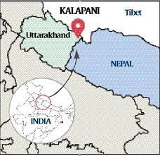
Key factors contributing to the new front in the India-Nepal border dispute are as follows:
- Territorial Claims: Both India and Nepal claim ownership of the Kalapani region. The dispute arises from differences in the interpretation of historical treaties and boundary demarcations. Nepal contends that the river Kali (also known as Mahakali) should be the boundary between the two countries, while India has historically considered the river’s eastern branch as the boundary.
- New Map and Constitutional Amendment: In November 2019, Nepal issued a new political map that included the Kalapani region within its borders. This was followed by a constitutional amendment to solidify the inclusion of the new map in Nepal’s official documents, further escalating the dispute.
- Security and Strategic Concerns: The Kalapani region holds significant strategic importance due to its proximity to the sensitive India-China border. Both India and Nepal have security interests in the area, making the dispute more complex and sensitive.
- Nationalism and Public Sentiment: The Kalapani dispute has evoked strong nationalist sentiments in both India and Nepal. Public sentiment and domestic politics in both countries have influenced their respective stances on the issue, making it difficult to find a mutually acceptable solution.
- Diplomatic Strain: The dispute has strained bilateral relations between India and Nepal. It has resulted in a suspension of high-level diplomatic engagements and has made negotiations more challenging.
- Cross-Border Implications: The dispute has implications beyond the India-Nepal border, as it involves the larger Himalayan region shared by both countries. Any resolution to the dispute must consider the interests of other stakeholders in the region, including China.
- Mediation Efforts: Various international actors, including China, have expressed interest in mediating the dispute. While India prefers bilateral dialogue with Nepal, the involvement of other parties adds a layer of complexity to resolving the issue.
Given the sensitive nature of the Kalapani dispute and its broader implications, finding a resolution will require diplomatic finesse, historical understanding, and willingness from both India and Nepal to address each other’s concerns. While the two countries share deep-rooted cultural, historical, and economic ties, resolving the border dispute and maintaining amicable relations remain crucial for regional stability and cooperation.
Q6. (a) Why do disparities in development and incomes between regions persist in large countries like India ? How does the recent ADP plan address the issue?
Ans: Disparities in development and incomes between regions persist in large countries like India due to a combination of historical, economic, social, and political factors.
Some of the key reasons for these disparities are:
- Historical Factors: Historical patterns of colonization, governance, and resource allocation have led to unequal development across regions. Some areas may have been historically favored with better infrastructure, investment, and economic opportunities, while others were neglected.
- Economic Factors: Natural resources, geographical location, and economic activities can significantly influence regional development. Areas with abundant natural resources or proximity to major economic centers tend to develop faster than remote or resource-poor regions.
- Social Factors: Social and cultural factors can also contribute to regional disparities. Caste, ethnicity, and social hierarchies may affect access to resources, education, and opportunities, leading to uneven development.
- Infrastructure and Connectivity: Disparities in infrastructure, such as roads, ports, and telecommunications, can impede economic development in some regions. Inadequate connectivity can limit trade, investment, and access to markets.
- Governance and Policy: The effectiveness of governance and public policies plays a significant role in shaping regional development. Uneven distribution of resources, inadequate implementation of welfare programs, and lack of regional-specific policies can exacerbate disparities.
- Migration and Urbanization: Migration patterns and urbanization can also contribute to regional imbalances. People often move from less developed regions to urban centers in search of better opportunities, leading to depopulation and underdevelopment in rural areas.
The recent ADP (All India Development Plan) seeks to address these regional disparities by focusing on inclusive and sustainable development. Some key aspects of the ADP that aim to tackle regional imbalances are:
- Area-Specific Development: The ADP emphasizes region-specific development programs to address the unique challenges faced by different regions. It aims to tailor policies to the specific needs of each area.
- Investment in Infrastructure: The ADP allocates funds for infrastructure development, including road networks, railways, and digital connectivity. Improving infrastructure in underdeveloped regions can boost economic activities and attract investments.
- Skill Development and Job Creation: The ADP prioritizes skill development initiatives to enhance the employability of the local workforce. Job creation in less developed regions can stem migration and promote balanced growth.
- Sustainable Agriculture and Rural Development: The ADP focuses on promoting sustainable agriculture practices and rural development to uplift rural economies and reduce the rural-urban divide.
- Special Economic Zones (SEZs): The ADP aims to create Special Economic Zones in less developed regions to attract investments and generate employment opportunities.
- Inclusive Social Welfare Programs: The ADP targets the expansion of social welfare programs, such as healthcare, education, and housing, to ensure that the benefits of development reach all sections of society.
While the ADP represents a step towards addressing regional disparities, its successful implementation depends on effective governance, efficient utilization of resources, and collaboration between the central and state governments. Tackling long-standing regional imbalances is a complex and ongoing process that requires sustained efforts and a multi-pronged approach.
(b) Critically examine the role of IRNSS-NavIC programme on the satellite navigation system of India.
Ans: The Indian Regional Navigation Satellite System (IRNSS), also known as NavIC (Navigation with Indian Constellation), is India’s indigenous satellite navigation system. It was designed to provide accurate and reliable position, navigation, and timing services over India and the surrounding region.
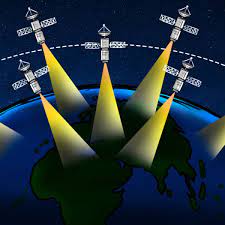
The critical examination of the role of the IRNSS-NavIC program on the satellite navigation system of India:
- Regional Coverage: The primary objective of NavIC is to provide accurate navigation services in the Indian region, covering a radius of around 1,500 kilometers beyond the Indian borders. NavIC is designed to cater to the unique requirements of the Indian subcontinent and its neighboring countries. However, its coverage is limited compared to the global navigation systems like GPS (Global Positioning System).
- Strategic Autonomy: Developing and deploying NavIC enhances India’s strategic autonomy in the realm of satellite navigation. Relying on indigenous navigation technology reduces dependency on foreign systems, thus ensuring secure and uninterrupted access to positioning and timing information, even during emergencies or conflicts.
- Disaster Management and National Security: NavIC plays a crucial role in disaster management and national security applications. Accurate timing information aids in synchronizing communication networks, disaster warning systems, and coordination during emergency responses. Additionally, it enhances the capabilities of the Indian Armed Forces in areas like target tracking, missile guidance, and precision-guided munitions.
- Scientific and Research Applications: The NavIC system benefits scientific research, particularly in the fields of geodesy, geophysics, and atmospheric sciences. Its precise positioning capabilities aid in monitoring tectonic movements, studying atmospheric conditions, and mapping natural resources.
- Socio-Economic Impact: NavIC contributes to socio-economic development by supporting location-based services, precision agriculture, transportation, and logistics. It enables improved efficiency and cost-effectiveness in various industries and enhances the overall economic potential of the region.
- Limited Global Coverage: One of the limitations of NavIC is its restricted global coverage compared to established global navigation systems like GPS and GLONASS. To achieve worldwide coverage, India would need to collaborate with other countries or invest in a constellation of satellites that extend beyond its regional boundaries.
- Technology Advancements: The development of NavIC has driven advancements in satellite technology and navigation systems in India. It showcases India’s capabilities in space technology and research.
- Interoperability: NavIC is designed to be interoperable with other global navigation systems, which allows users to access a combined and more accurate positioning service. However, interoperability challenges and compatibility issues with other systems may need to be addressed to maximize its benefits.
In conclusion, the IRNSS-NavIC program has significantly contributed to India’s satellite navigation capabilities, providing strategic autonomy, enhancing national security, and supporting socio-economic development. While NavIC has demonstrated its effectiveness in the Indian region, further efforts are required to achieve global coverage and ensure seamless integration with other global navigation systems. Continuous investment in research, development, and international cooperation will be vital to the long-term success and competitiveness of NavIC on the global stage.
(c) Examine the role of high population concentration in Indian slums in making them more vulnerable during pandemic conditions like the COVID-19.
Ans: The high population concentration in Indian slums makes them particularly vulnerable during pandemic conditions like the COVID-19 outbreak.
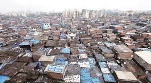
Several factors contribute to this vulnerability:
- Overcrowding: Slums are characterized by dense and overcrowded living conditions, with limited space and inadequate ventilation. The close proximity of households and individuals makes social distancing challenging, increasing the risk of virus transmission within the community.
- Limited Access to Healthcare: Slum dwellers often face limited access to healthcare facilities, including hospitals, clinics, and medical personnel. This lack of healthcare infrastructure can impede timely testing, diagnosis, and treatment for COVID-19 cases, leading to a higher likelihood of community spread.
- Poor Sanitation and Hygiene: In many slums, access to clean water and sanitation facilities is scarce. Lack of proper sanitation and hygiene practices can facilitate the spread of the virus through contaminated surfaces and poor personal hygiene.
- Informal and Unorganized Sector: A significant portion of slum residents works in the informal sector, with irregular income and minimal job security. During pandemics, restrictions on movement and economic activities can lead to loss of livelihoods and financial hardships, exacerbating the vulnerability of slum dwellers.
- Limited Awareness and Education: Slum communities may have limited access to information and education about preventive measures against COVID-19. Misinformation and lack of awareness can hinder the adoption of preventive practices, such as wearing masks and practicing hand hygiene.
- Pre-existing Health Conditions: Slum dwellers often face health challenges due to inadequate nutrition, exposure to environmental pollutants, and limited access to healthcare. Pre-existing health conditions can increase the severity of COVID-19 infections among vulnerable individuals.
- Informal Social Networks: While strong social networks can provide support during crises, informal social networks in slums may facilitate the spread of the virus. Social gatherings and community events can become potential hotspots for transmission.
- Migration and Mobility: Slum populations are often transient, with significant migration within and between cities. Migrant workers returning to their hometowns during the pandemic may inadvertently carry and spread the virus to rural areas.
- Challenges in Isolation and Quarantine: The high population density in slums can make it challenging to isolate or quarantine infected individuals effectively. Isolation facilities and support services may be limited, making containment efforts less effective.
To address the vulnerabilities of slum dwellers during pandemics, governments and non-governmental organizations should focus on targeted interventions like:
- Increasing Healthcare Access: Enhancing healthcare infrastructure and establishing temporary healthcare facilities in slum areas can help in early detection, isolation, and treatment of COVID-19 cases.
- Improving Sanitation and Hygiene: Providing access to clean water, sanitation facilities, and hygiene kits can promote preventive measures and reduce the risk of virus transmission.
- Community Engagement and Awareness: Conducting awareness campaigns in local languages, using community leaders as influencers, and leveraging local media can improve understanding of preventive measures.
- Social Support and Livelihood Assistance: Providing financial support, food assistance, and livelihood opportunities for slum dwellers can mitigate the economic impact of lockdowns and encourage adherence to preventive measures.
- Targeted Testing and Contact Tracing: Conducting targeted testing and efficient contact tracing in slum areas can help identify and isolate cases early, preventing further spread.
By addressing the unique challenges faced by slum dwellers during pandemics, authorities can reduce the vulnerability of these communities and enhance overall pandemic response and containment efforts.
Q7. (a) Discuss the salient characteristics of industrial complexes of Western India. Examine the impact of SEZ policy on the region.
Ans: The industrial complexes of Western India are characterized by certain distinctive features that have contributed to the region’s economic development and industrial growth.
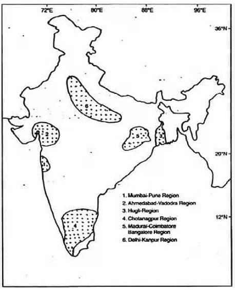
Some salient characteristics of these industrial complexes include:
- Geographic Location: Western India is strategically located, with access to major ports and transportation networks. States like Maharashtra and Gujarat have a long coastline, which facilitates easy import and export of goods, making them attractive locations for industrial activities.
- Diverse Industries: The industrial complexes in Western India are known for their diverse range of industries, including petrochemicals, textiles, pharmaceuticals, automobiles, engineering, and information technology. This diversity contributes to a balanced economic development in the region.
- Entrepreneurial Spirit: Western India has a history of entrepreneurialism, with a strong culture of trade and business. This spirit has driven industrial growth and investment in the region.
- Infrastructure: The region boasts well-developed infrastructure, including modern ports, well-connected road and rail networks, and reliable power supply, which is crucial for the establishment and growth of industries.
- Special Economic Zones (SEZs): The implementation of SEZ policy in the region has attracted significant investment and provided favorable conditions for industrial growth. SEZs offer tax incentives, simplified regulatory procedures, and infrastructure support, making them attractive destinations for both domestic and foreign investors.
- Export-Oriented Industries: Many industries in Western India are export-oriented, contributing significantly to India’s foreign trade. The region’s proximity to major international markets has made it a preferred location for export-oriented units.
Impact of SEZ Policy on Western India:
The SEZ policy has had a profound impact on the industrial complexes of Western India, transforming the region into a major hub for industrial growth and export-oriented industries. Some key impacts include:
- Foreign Direct Investment (FDI): The SEZ policy has attracted significant foreign direct investment to the region. Foreign companies set up manufacturing units in SEZs to benefit from tax exemptions and other incentives, boosting industrial growth and employment opportunities.
- Employment Generation: The establishment of SEZs has created employment opportunities for the local population. The growth of industries in the region has led to a rise in skilled and semi-skilled jobs, improving the socio-economic conditions of the people.
- Export Growth: SEZs in Western India have facilitated a surge in export-oriented industries. The tax benefits and export incentives provided to SEZ units have boosted the region’s contribution to India’s exports.
- Infrastructure Development: The development of SEZs has necessitated the creation of supporting infrastructure, including roads, power supply, and housing. This has led to overall development in the region.
- Technology Transfer: SEZs have encouraged technology transfer through collaborations between domestic and foreign companies. This has facilitated the adoption of advanced technologies in domestic industries, enhancing their competitiveness.
- Balanced Regional Development: The SEZ policy has contributed to balanced regional development by attracting industries to regions with high growth potential. This has reduced the concentration of industries in specific areas and encouraged development in less-developed regions.
However, it is essential to note that the SEZ policy has also faced criticism for some challenges, including land acquisition issues, environmental concerns, and concerns over labor rights and working conditions. Addressing these challenges is crucial to ensuring that the SEZ policy continues to contribute positively to the industrial development of Western India while being socially and environmentally sustainable.
(b) Discuss the emergence of linguistic regions and states in India.
Ans: The emergence of linguistic regions and states in India is a significant aspect of the country’s post-independence political and administrative history. Language has played a crucial role in shaping the identity and political aspirations of various communities across India. The linguistic reorganization of states can be traced back to the pre-independence period and gained momentum after India’s independence in 1947.
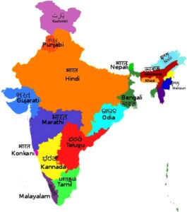
Key developments in the emergence of linguistic regions and states in India:
- Linguistic Diversity: India is a linguistically diverse country with hundreds of languages and dialects spoken across its vast geographical expanse. Language has been a vital marker of identity and cultural expression for various communities.
- British Colonial Legacy: During British colonial rule, administrative boundaries were primarily drawn based on political and strategic considerations, disregarding linguistic and cultural affinities. As a result, post-independence India inherited states with diverse linguistic populations.
- Potti Sriramulu and Andhra Movement: The Andhra movement in the 1950s was a significant early example of a linguistic-based demand for a separate state. Potti Sriramulu’s fast-unto-death for the formation of Andhra state, distinct from the Madras Presidency, led to the formation of Andhra Pradesh in 1953.
- States Reorganization Commission: To address the demand for linguistic states, the government constituted the States Reorganization Commission (SRC) in 1953. The SRC, led by Fazal Ali, K.M. Panikkar, and H.N. Kunzru, recommended the reorganization of states based on linguistic lines.
- Linguistic States Reorganization Act, 1956: The SRC’s recommendations formed the basis of the Linguistic States Reorganization Act, which was passed in 1956. As per the act, India was reorganized into 14 states and six union territories based on linguistic lines, significantly altering the administrative map of the country.
- Emergence of New States: The linguistic reorganization led to the formation of several new states, such as Maharashtra, Gujarat, Karnataka, Tamil Nadu, and Kerala, based on linguistic identity. These states aimed to preserve and promote their respective languages and cultures.
- Ongoing Demands: Even after the initial linguistic reorganization, demands for separate states based on language continued in various regions. Some of these demands were realized over time, leading to the creation of states like Haryana, Chhattisgarh, Uttarakhand, and Telangana.
- Lingual Identity and Political Representation: The linguistic reorganization of states has allowed different linguistic communities to assert their cultural identity and gain better political representation and governance in their own language.
- Challenges and Opportunities: While linguistic reorganization has facilitated the preservation of languages and cultures, it has also posed administrative and governance challenges due to diverse linguistic populations. Ensuring equitable development and managing inter-state water and resource disputes remain ongoing concerns.
The emergence of linguistic regions and states in India has been a transformative process, shaping the country’s political landscape and governance structure. It reflects the country’s commitment to recognizing and accommodating linguistic diversity, while also presenting challenges in managing regional aspirations and ensuring harmonious coexistence among different linguistic communities.
(c) What are the drivers of urban sprawl around the major cities of the country? How have new investments in transport projects supported sprawl development ?
Ans: Urban sprawl around major cities in India is primarily driven by a combination of demographic, economic, and policy factors.
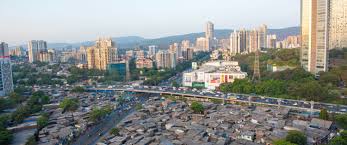
Some of the key drivers of urban sprawl include:
- Population Growth: Rapid population growth in major cities has led to increased demand for housing and infrastructure, pushing development further into the outskirts and surrounding areas.
- Real Estate Development: The real estate industry’s focus on building housing and commercial projects in peri-urban and suburban areas has contributed to urban sprawl. Developers often find more available land and lower costs outside the city core.
- Infrastructure Development: Improvements in transportation infrastructure, such as highways, expressways, and metro rail networks, have facilitated connectivity between the city center and the outskirts, making distant areas more accessible for residential and commercial development.
- Land Use Policies: Zoning and land use policies that favor urban expansion have also played a role in encouraging development in peri-urban areas. In some cases, land use regulations may be more relaxed outside the city center, encouraging developers to invest in suburban locations.
- Economic Opportunities: The availability of land and lower costs on the urban periphery can attract businesses and industries to set up their operations in these areas, leading to economic activities and further development.
- Housing Affordability: Rising housing costs in the city center can push residents to seek more affordable housing options in the suburbs, contributing to urban sprawl.
- Decentralization of Services: The establishment of schools, hospitals, and shopping centers in the suburban areas can lead to the decentralization of services, encouraging people to settle in these locations.
Investments in transport projects, particularly road and rail infrastructure, can support sprawl development by improving connectivity and reducing travel time between the city center and suburban areas. Some ways in which new investments in transport projects contribute to urban sprawl include:
- Improved Accessibility: New transport projects, such as highways and expressways, can reduce travel time between the city center and suburban areas, making these areas more attractive for residential and commercial development.
- Commuter Rail and Metro Networks: The expansion of commuter rail and metro networks can facilitate commuting from the suburbs to the city center, encouraging people to settle in distant areas while maintaining access to urban amenities and employment opportunities.
- Satellite Towns and Growth Corridors: Transport projects that connect satellite towns and growth corridors to the city center can promote development in these areas by providing efficient transportation options.
- Land Value Appreciation: Transport projects often lead to an increase in land value along their routes. Developers may take advantage of this appreciation by acquiring land in the suburban areas and developing new projects.
- Development of Transport Nodes: Transport projects can stimulate commercial and residential development around transport nodes, such as interchanges and metro stations, leading to the expansion of urban areas in these locations.
While new investments in transport projects can enhance connectivity and accessibility, they also need to be planned and managed carefully to avoid excessive sprawl and ensure sustainable urban development. Integrating land use and transportation planning, promoting transit-oriented development, and implementing smart growth policies are essential to strike a balance between urban expansion and sustainable development around major cities.
Q8. (a) How do agro-climatic and land capability indicators assist in macro-agricultural regionalisation of India? Illustrate with an appropriate map.
Ans: Agro-climatic and land capability indicators play a crucial role in macro-agricultural regionalization of India. They help in identifying and categorizing different regions based on their suitability for various agricultural activities, taking into account factors such as climate, soil types, and topography. This macro-regionalization is essential for formulating targeted agricultural policies, crop planning, and resource allocation in different regions to enhance agricultural productivity and sustainability.
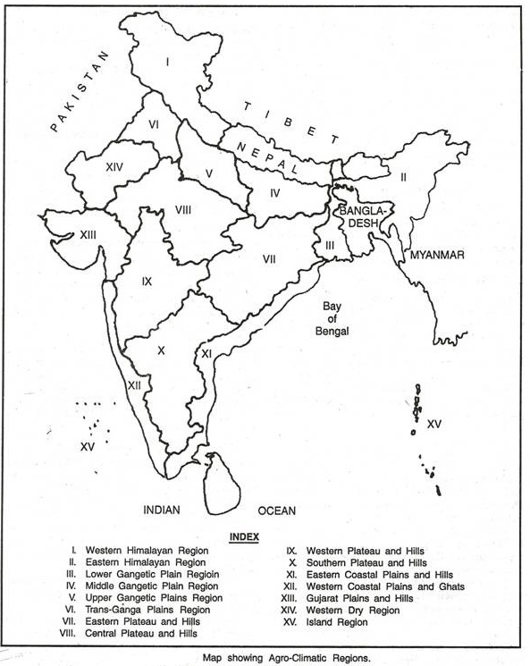
To illustrate this concept, let’s consider a map that shows the macro-agricultural regions of India based on agro-climatic and land capability indicators:
In this map, India is divided into different macro-agricultural regions, each represented by a unique color:
- Western Himalayas: This region comprises the hilly areas of Jammu & Kashmir, Himachal Pradesh, and Uttarakhand. It is characterized by a temperate climate with suitable conditions for temperate fruit cultivation like apples and pears. The land capability indicators show the presence of steep slopes and limited arable land, limiting extensive agriculture.
- Indo-Gangetic Plains: The vast plains of northern India, including states like Punjab, Haryana, Uttar Pradesh, and Bihar, constitute this region. The agro-climatic conditions are favorable for the cultivation of crops like wheat, rice, sugarcane, and pulses. The land capability indicators suggest fertile alluvial soils and ample water resources, making it highly suitable for intensive agriculture.
- Central India Plateau: This region includes parts of Madhya Pradesh, Chhattisgarh, and parts of Maharashtra. The agro-climatic conditions support the cultivation of oilseeds, soybeans, cotton, and millets. The land capability indicators show a mix of black soils and red soils, offering good agricultural potential.
- Western India: Encompassing Gujarat, Rajasthan, and parts of Maharashtra, this region is characterized by arid and semi-arid conditions. The agro-climatic indicators suggest the cultivation of drought-resistant crops like millets, sorghum, and pulses. The land capability indicators show that the region has sandy and loamy soils, making it suitable for dryland farming.
- Eastern Ghats and Deccan Plateau: This region includes parts of Andhra Pradesh, Telangana, Karnataka, and Tamil Nadu. The agro-climatic conditions support the cultivation of crops like rice, cotton, groundnut, and pulses. The land capability indicators reveal a mix of red and black soils, along with some rocky and hilly terrains.
- Eastern Himalayas and Northeast: This region consists of the hilly and northeastern states of India. The agro-climatic conditions favor the cultivation of crops like tea, coffee, spices, and fruits. The land capability indicators indicate a mix of forested and hilly terrains, with some areas suitable for plantation crops.
By analyzing these agro-climatic and land capability indicators, policymakers can develop targeted agricultural strategies, recommend suitable crop choices, and allocate resources appropriately for sustainable and efficient agricultural development across different macro-agricultural regions of India. This approach can help enhance agricultural productivity, reduce regional disparities, and promote overall agricultural growth in the country.
(b) Discuss the geopolitical significance of Quad in the Indo-Pacific realm with reference to marine trade in the region.
Ans: The Quadrilateral Security Dialogue, commonly known as the Quad, is a strategic forum comprising four Indo-Pacific countries: India, Japan, Australia, and the United States.
The Quad’s geopolitical significance in the Indo-Pacific realm, particularly concerning marine trade in the region, is shaped by several factors:
- Ensuring Maritime Security: The Indo-Pacific region is a vital hub for international maritime trade, accounting for a significant portion of global trade routes. The Quad countries share common concerns about ensuring the security and stability of these sea lanes, which are critical for the movement of goods, energy resources, and raw materials. Through cooperative efforts, the Quad aims to counter piracy, maritime terrorism, and other security threats that could disrupt marine trade.
- Balancing China’s Influence: The emergence of China as a major maritime power in the Indo-Pacific has raised concerns among the Quad countries about its assertiveness in the South China Sea and the Indian Ocean region. The Quad is viewed as a platform to promote a rules-based order and ensure freedom of navigation and overflight in international waters. It serves as a mechanism to balance China’s growing influence and assertiveness in the region, thereby safeguarding the interests of all Quad countries in marine trade.
- Infrastructure and Connectivity: The Quad countries are actively engaged in promoting infrastructure development and connectivity projects in the Indo-Pacific region. By investing in ports, roads, and other connectivity initiatives, the Quad aims to enhance trade and economic ties, improve the efficiency of transport networks, and boost economic growth in partner countries. This, in turn, has implications for marine trade as it facilitates smoother movement of goods and enhances regional economic integration.
- Disaster Response and Humanitarian Assistance: The Quad countries collaborate on disaster response and humanitarian assistance in the Indo-Pacific. Natural disasters and emergencies in the region can disrupt maritime trade and have significant humanitarian consequences. By pooling resources and coordinating efforts, the Quad seeks to enhance disaster preparedness and response capabilities, thereby contributing to the swift restoration of trade routes and supply chains.
- Maritime Domain Awareness: The Quad countries engage in joint exercises and information sharing to enhance maritime domain awareness in the Indo-Pacific. By bolstering surveillance and intelligence capabilities, the Quad aims to detect and respond to potential security threats in the region. This contributes to maintaining the safety and security of sea lanes critical for marine trade.
- Strategic Partnerships: The Quad countries are strengthening their strategic partnerships with other regional actors, such as ASEAN countries and other like-minded states. These partnerships foster greater collaboration on maritime security, trade facilitation, and infrastructure development, thus promoting stability and prosperity in the Indo-Pacific.
In conclusion, the Quad’s geopolitical significance in the Indo-Pacific realm with reference to marine trade lies in its efforts to ensure maritime security, balance China’s influence, promote infrastructure and connectivity, respond to disasters, enhance maritime domain awareness, and build strategic partnerships. By fostering cooperation and addressing common challenges, the Quad aims to safeguard the free and open nature of the Indo-Pacific maritime domain, which is essential for the uninterrupted flow of marine trade and regional prosperity.
(c) Evaluate the role of the National Food Security Act, 2013 in providing access of food to the poor in India.
Ans: The National Food Security Act (NFSA), 2013, is a landmark legislation in India aimed at ensuring food security for its population, particularly the poor and vulnerable sections. The act seeks to provide subsidized food grains to a large number of beneficiaries, enhance nutritional support, and reduce hunger and malnutrition in the country. Let’s evaluate the role of the NFSA in providing access to food for the poor in India:
- Targeted Beneficiaries: The NFSA identifies priority households and eligible beneficiaries, including pregnant women, lactating mothers, children, and certain marginalized sections of society, such as Scheduled Castes (SCs), Scheduled Tribes (STs), and other vulnerable groups. By targeting specific beneficiaries, the act aims to direct food support to those who need it the most.
- Food Grains Entitlement: Under the NFSA, eligible households are entitled to receive a specified quantity of subsidized food grains each month. The beneficiaries are provided with rice, wheat, and coarse grains at affordable prices, ensuring a stable supply of essential food items.
- Affordable Prices: The act provides food grains at highly subsidized rates to the beneficiaries. The prices at which food grains are distributed under the Public Distribution System (PDS) are much lower than the market prices, making it affordable for the poor to access essential food items.
- Strengthening PDS: The NFSA aims to strengthen the Public Distribution System, which plays a critical role in the distribution of food grains to beneficiaries. The act emphasizes the use of technology and Aadhaar-based identification to ensure transparent and efficient delivery of food grains.
- Nutritional Support: The act includes provisions for the distribution of nutritious food items, such as fortified food grains, pulses, and edible oils, to improve the nutritional status of beneficiaries, especially women and children.
- Maternity Benefits: The NFSA also provides for maternity benefits, wherein pregnant women and lactating mothers are entitled to nutritious meals and an additional food grain allocation during pregnancy and up to six months after childbirth.
Despite its laudable objectives, the implementation of the NFSA has faced some challenges:
- Identification of Beneficiaries: Accurate identification and targeting of beneficiaries have been a persistent challenge. The process of identification and exclusion errors can lead to the exclusion of some eligible households and inclusion of some ineligible ones.
- Leakages and Corruption: Leakages and diversion of food grains in the PDS have been reported in various states. These leakages can deprive the intended beneficiaries of their entitlements.
- Storage and Distribution: Inadequate storage facilities and logistical challenges in distribution have led to delays in reaching food grains to beneficiaries, especially in remote and rural areas.
- Fiscal Burden: The financial burden of implementing the NFSA has been significant, particularly in terms of subsidizing food grains. There have been concerns about the long-term sustainability of the act and its impact on fiscal deficits.
- Nutritional Quality: While the NFSA emphasizes the distribution of fortified food items, ensuring the availability and quality of these items has been a challenge.
In conclusion, the National Food Security Act, 2013, has made significant strides in improving food security and access to food for the poor in India. It has expanded the scope of food-based welfare programs and enhanced the availability of subsidized food grains to eligible beneficiaries. However, there are implementation challenges that need to be addressed, such as accurate beneficiary identification, leakages in the PDS, and nutritional quality. Policymakers need to continue monitoring the implementation and make necessary improvements to ensure the effective functioning of the NFSA and its ability to achieve its intended goals of providing food security to the poor.
Thanks for reading this article on UPSC Geography Optional Question Paper -2, 2022 [Solved].
Read
