Geography Optional Question Paper-1 (2022)
Section-A
Q. 1 Answer the following in about 150 words each:
a) Define ‘speleothem’. Discuss the various forms and features of speleothems.
Ans: A speleothem is a mineral deposit that forms in a cave or other underground space as a result of water percolating through the rock and carrying dissolved minerals. Speleothems are also called cave formations and are typically composed of various types of calcium carbonate minerals, such as calcite or aragonite, although they can also include other minerals like gypsum or quartz.

Speleothems come in a wide variety of forms and sizes, depending on the conditions under which they were formed. Some common types of speleothems include:
- Stalactites: These are pointed, icicle-like formations that hang from the ceiling of a cave. Stalactites form when water containing dissolved minerals drips from the ceiling and leaves behind mineral deposits that build up over time.
- Stalagmites: These are column-like formations that grow up from the floor of a cave. Stalagmites form when mineral-rich water drips onto the cave floor and leaves behind deposits that accumulate over time.
Speleothems can also exhibit a variety of features, such as banding, coloration, and crystalline structure, that provide clues to the conditions under which they were formed.
b) What are the high altitude environmental hazards? Explain with suitable examples.
Ans: High altitude environments pose several environmental hazards to humans due to the combination of low air pressure, low oxygen levels, extreme temperatures, and intense solar radiation. Here are some of the high altitude environmental hazards and their examples:

- Hypoxia: Hypoxia is a condition where the body doesn’t get enough oxygen, which can lead to dizziness, fatigue, and other symptoms. At high altitudes, the air pressure is low, so there is less oxygen in the air. For example, climbers on Mount Everest, which is over 29,000 feet high, experience severe hypoxia due to the low oxygen levels.
- Cold: High altitudes can be extremely cold, and temperatures can drop well below freezing. For example, temperatures on Mount Everest can drop to as low as -40°C. Hypothermia, a condition where the body’s core temperature drops below the normal range, is a significant risk in such conditions.
- Dehydration: High altitude environments are often dry, and the air is thin and dry, which can lead to dehydration. For example, climbers on Mount Everest, Mount Kilimanjaro have to consume up to 5-6 liters of water daily to avoid dehydration.
- Sunburn: High altitude environments are closer to the sun, and the thinner atmosphere provides less protection from solar radiation. This makes climbers more prone to sunburn, which can be severe at high altitudes.
- Avalanches: High altitude environments are prone to avalanches, especially in areas with steep slopes and heavy snowfall. For example, the Khumbu Icefall on Mount Everest is notorious for its avalanches, and climbers have to be extremely cautious when crossing it.
In summary, high altitude environments pose several hazards to humans, including hypoxia, cold, dehydration, sunburn, altitude sickness, and avalanches. It is essential to be aware of these hazards and take appropriate precautions when traveling or climbing in such environments.
c) What is pollution dome? Discuss its formation and impacts.
Ans: A pollution dome, also known as an inversion layer, is a type of air pollution event where a layer of cold air is trapped below a layer of hot air near the ground. This creates a dome-like shape that prevents the dispersion of pollutants into the atmosphere, leading to the accumulation of high concentrations of pollutants in the lower layer.
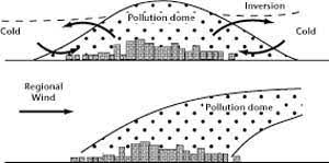
The formation of a pollution dome is typically caused by a combination of meteorological conditions and human activities. During the day, the sun heats the ground, which in turn heats the air above it. This warm air rises, allowing pollutants to disperse and mix with the surrounding air. However, at night, the ground cools faster than the air above it, leading to the formation of a stable layer of cooler air near the ground. If there is little or no wind, this cool air gets trapped under a layer of warmer air, creating a pollution dome.
Human activities, such as industrial processes and transportation, can also contribute to the formation of pollution domes by emitting large quantities of pollutants into the atmosphere. These pollutants can accumulate and become trapped under the inversion layer, leading to high concentrations of pollutants in the lower layer.
The impacts of pollution domes can be severe, particularly on human health. High levels of pollutants, such as nitrogen oxides, sulfur dioxide, and particulate matter, can cause respiratory problems, aggravate asthma, and increase the risk of heart disease. Additionally, pollution domes can have economic impacts by reducing visibility, damaging crops, and decreasing tourism. To mitigate the formation of pollution domes, it is important to reduce emissions of pollutants from human activities and improve air quality monitoring and forecasting.
d) When corals are affected by stress it causes them to turn completely white. Explain the reasons of such an occurrence.
Ans: The phenomenon of corals turning completely white, known as coral bleaching. It occurs when corals become stressed due to changes in their environment, such as increased water temperatures, pollution, or changes in water chemistry.
Corals have a symbiotic relationship with tiny algae called zooxanthellae, which live inside their tissues and provide them with essential nutrients through photosynthesis. When corals become stressed, they expel the zooxanthellae from their tissues in a process called “bleaching.”
Without their zooxanthellae, corals lose their source of nutrition and become more susceptible to disease and death. The loss of zooxanthellae also causes the corals to turn completely white, as the pigments that give them their color are derived from the algae.
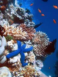
Coral bleaching is a serious concern for the health of coral reefs and the organisms that depend on them. It is often linked to climate change, as rising water temperatures can cause corals to become stressed and bleach more frequently.

Reducing greenhouse gas emissions and addressing other environmental stressors, such as pollution and overfishing, are critical steps in protecting coral reefs and the valuable ecosystems they support.
e) Well developed soils typically exhibit distinct layers in their soil profile. Elaborate.
Ans: Yes, well-developed soils usually have distinct layers, or soil horizons, that form as a result of various soil-forming processes over time. These horizons can provide important information about the history and characteristics of the soil, as well as its potential for various uses.
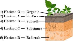
There are typically five main horizons in a soil profile, depending on the classification system used. These include:
- The O horizon: This is the topmost layer of the soil, composed mainly of organic matter such as leaf litter, grasses, and other decomposing plant material. The O horizon is important for soil fertility and nutrient cycling, as it provides a source of nutrients for plants.
- The A horizon: Also known as the topsoil, this layer is typically the most fertile and productive part of the soil. It contains a mixture of mineral particles, organic matter, and microorganisms that help to break down organic material and release nutrients for plants. This layer is often darker in color than the layers below it due to the accumulation of organic matter.
- The B horizon: This layer is also known as the subsoil and is usually less fertile than the topsoil. It is composed of larger mineral particles, such as sand, silt, and clay, and may also contain accumulations of minerals like iron, aluminum, and calcium carbonate. These minerals can give the B horizon a distinctive color or texture.
- The C horizon: This layer is composed of weathered parent material that has not yet been transformed into soil. It may contain large rocks or boulders, or be composed of unconsolidated material such as sand or gravel.
- The R horizon: This layer is the bedrock or consolidated rock beneath the soil, and is not considered part of the soil proper.
These soil horizons form as a result of various soil-forming processes, including weathering, erosion, deposition, and biological activity. The exact nature of the horizons will depend on factors such as climate, topography, vegetation, and parent material. By studying the soil profile, soil scientists can gain important insights into the history and characteristics of the soil, as well as its potential for various uses such as agriculture, forestry, or construction.
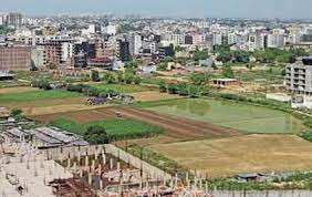
Q. 2 a) Sequential changes in land use and land cover have brought global and regional ecological changes and imbalances. Elucidate.
Ans: Sequential changes in land use and land cover have indeed brought about global and regional ecological changes and imbalances.
Let’s explore the impact of such changes in more detail:
- Loss of Biodiversity: Land use changes, such as deforestation, urbanization, and conversion of natural habitats to agricultural land, have resulted in the loss and fragmentation of ecosystems. This has led to a significant decline in biodiversity worldwide. Species that rely on specific habitats or have limited ranges are particularly vulnerable, which can disrupt ecosystems and reduce ecosystem resilience.
- Habitat Destruction: Conversion of natural habitats for agriculture, infrastructure development, or resource extraction has led to the destruction and fragmentation of ecosystems. This has resulted in the loss of critical habitats for many plant and animal species, leading to species decline and, in some cases, extinction. Habitat destruction disrupts ecological processes, including nutrient cycling, pollination, and seed dispersal.
- Climate Change: Changes in land use and land cover, such as deforestation, contribute to climate change. Forests act as carbon sinks, absorbing and storing carbon dioxide from the atmosphere. Deforestation releases large amounts of carbon dioxide, exacerbating greenhouse gas emissions and contributing to global warming. Changes in land cover, such as the expansion of urban areas or agricultural land, can also alter local climate patterns.
- Soil Degradation: Unsustainable land use practices, including intensive agriculture and improper land management, can lead to soil degradation. Soil erosion, nutrient depletion, and contamination can reduce soil fertility and productivity. Soil degradation affects agricultural productivity, leading to decreased crop yields and food security challenges.
- Water Resource Impacts: Land use changes can have significant impacts on water resources. Deforestation and land degradation can disrupt hydrological cycles, leading to altered water availability, reduced groundwater recharge, and increased vulnerability to floods and droughts. Changes in land use patterns can also contribute to water pollution through increased sedimentation, runoff of chemicals, and loss of natural filtration systems.
- Loss of Ecosystem Services: Changes in land use and land cover can result in the loss or degradation of essential ecosystem services. These services include water purification, climate regulation, soil fertility, pollination, and natural pest control. The loss of these services can have cascading effects on human well-being, agricultural productivity, and the resilience of ecosystems.
- Ecological Imbalances: Sequential changes in land use and land cover often disrupt the natural balance and functioning of ecosystems. Loss of key species, disruption of ecological processes, and alterations in energy flows can lead to ecological imbalances. These imbalances can result in increased invasive species, outbreaks of pests and diseases, and shifts in ecological interactions, which can further impact biodiversity and ecosystem functioning.
Addressing the ecological changes and imbalances resulting from land use changes requires sustainable land management practices, conservation efforts, and policy interventions. Preserving natural habitats, promoting sustainable agriculture, reforestation, and adopting integrated land-use planning approaches are crucial for mitigating the adverse ecological impacts and achieving a more sustainable and balanced relationship between human activities and the environment.
b) Explain how various aspects of channel morphology are used in transportation, settlement and land use planning, flood control and flood management?
Ans: Channel morphology refers to the physical characteristics and features of a river or stream channel, including its shape, size, cross-sectional profile, bed materials, and bank stability. Understanding channel morphology is crucial for various aspects of transportation, settlement and land use planning, flood control, and flood management.
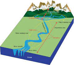
Let’s explore how each of these areas is influenced by channel morphology:
- Transportation: Channel morphology plays a significant role in transportation, especially for water-based transportation. Rivers and channels with favorable morphology, such as a stable and straight channel with adequate depth, can facilitate navigation and reduce the cost and time associated with transporting goods. Dredging and maintaining the channel’s shape and depth are essential to ensure that ships and boats can navigate safely. Additionally, knowledge of channel morphology helps identify potential hazards like shallow areas, bends, or narrow sections that might require engineering interventions to improve navigability.
- Settlement and Land Use Planning: In the context of urban planning and settlement development, channel morphology has implications for flood risk, infrastructure, and land use allocation. Understanding the natural floodplains and sedimentation patterns helps avoid building in hazardous areas prone to flooding. Settlements must be strategically planned to ensure they are not located within flood-prone zones. Moreover, preserving the natural channel morphology in urban areas and accounting for it in land use planning helps maintain ecological balance, reduce erosion, and prevent waterlogging issues.
- Flood Control: Channel morphology is directly linked to flood control strategies. Rivers with complex meandering patterns or insufficient capacity may experience higher flood risks. In such cases, it may be necessary to engineer the channel to increase its flow capacity, control sediment deposition, and minimize the potential for floods. Methods like channel widening, constructing levees, or building flood control reservoirs are based on an understanding of the river’s morphology and its ability to handle large volumes of water.
- Flood Management: Flood management involves a holistic approach to dealing with flood events. Knowledge of channel morphology is crucial for flood forecasting, modeling, and designing appropriate flood management measures. By analyzing the river’s past behavior and its current morphology, experts can create floodplain maps and flood risk assessments. Additionally, understanding sediment transport in the channel helps in predicting the long-term changes in river morphology and planning for future flood scenarios.
In summary, channel morphology is a critical factor in various aspects of human activities and natural processes related to watercourses. Its understanding is essential for efficient transportation, safe and sustainable settlement development, effective flood control measures, and comprehensive flood management strategies. By incorporating channel morphology data into planning and decision-making processes, we can minimize the adverse impacts of water-related hazards and ensure better utilization of river systems for human benefit.
c) What is the relationship between ocean currents and global surface wind systems? Explain with examples how does the gyre in the Northern Hemisphere differ from the one in the Southern Hemisphere.
Ans: The relationship between ocean currents and global surface wind systems is crucial for understanding the circulation patterns in the Earth’s oceans. Winds blowing across the surface of the ocean create friction with the water, which, in turn, sets the ocean water in motion, generating currents. These ocean currents, in return, play a significant role in redistributing heat around the planet and influencing weather patterns.
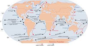
The major global wind systems that influence ocean currents are the trade winds, westerlies, and polar easterlies.
- Trade Winds: These are steady winds that blow from the subtropical high-pressure regions towards the equator. In the Northern Hemisphere, they blow from the northeast, and in the Southern Hemisphere, they blow from the southeast.
- Westerlies: These are prevailing winds that blow from the subtropical high-pressure regions towards the mid-latitudes (around 30° to 60° latitude). In the Northern Hemisphere, they blow from the southwest, and in the Southern Hemisphere, they blow from the northwest.
- Polar Easterlies: These are cold winds that blow from the polar high-pressure regions towards the mid-latitudes. In the Northern Hemisphere, they blow from the northeast, and in the Southern Hemisphere, they blow from the southeast.
Now, let’s look at the gyres in the Northern and Southern Hemispheres and their differences:
Northern Hemisphere Gyre (North Atlantic Gyre): The North Atlantic Gyre is a large circular system of ocean currents in the North Atlantic Ocean. The main currents in this gyre are the Gulf Stream and the North Atlantic Drift. Here’s how the gyre operates:
- Trade Winds: The trade winds blow from the northeast, pushing surface waters towards the equator.
- Gulf Stream: The warm water from the Gulf of Mexico is carried by the North Equatorial Current, driven by the trade winds, and flows northeastward along the eastern coast of the United States. This powerful current is known as the Gulf Stream.
- Westerlies: As the Gulf Stream reaches higher latitudes, it meets the prevailing westerlies, which drive the current towards the east. This flow completes the gyre as it returns southward along the eastern side of the Atlantic Ocean.
Southern Hemisphere Gyre (South Atlantic Gyre): The South Atlantic Gyre is the counterpart to the North Atlantic Gyre and operates in a similar fashion but with some differences:
- Trade Winds: In the Southern Hemisphere, the trade winds blow from the southeast, driving surface waters towards the equator.
- Brazil Current: The South Equatorial Current carries warm water westward along the equator. Some of this water enters the Caribbean Sea and eventually becomes the warm Brazil Current.
- Westerlies: The Brazil Current continues southward and meets the prevailing westerlies, which push the current towards the east. The flow then completes the gyre as it returns northward along the western side of the Atlantic Ocean.
Differences between the Northern and Southern Hemisphere Gyres:
| Aspect | Northern Hemisphere Gyre | Southern Hemisphere Gyre |
|---|---|---|
| Dominant Wind Direction | Trade winds blow from the northeast. | Trade winds blow from the southeast. |
| Gyre Circulation Direction | Clockwise rotation due to the Coriolis effect. | Counterclockwise rotation due to the Coriolis effect. |
| Major Currents | Gulf Stream and North Atlantic Drift. | Brazil Current. |
| Size and Strength | Larger and more powerful due to larger landmasses and temperature contrasts. | Smaller and less powerful. |
| Impact on Climate | Influences the distribution of heat and moisture across Europe and North America. | Lesser impact on regional climates. |
Q. 3 a) Plants and animals that exist in a particulars ecosystem are those that have been successful in adjusting to their habitat and environmental conditions. Elucidate with examples.
Ans: Plants and animals that exist in a particular ecosystem are those that have successfully adapted to the specific habitat and environmental conditions of that ecosystem. Natural selection, over generations, favors individuals with traits that increase their chances of survival and reproduction in their environment, leading to the dominance of specific species that are well-suited to that ecosystem. Let’s elaborate with some examples:
Desert Ecosystem
Plants: Cacti are well-adapted to desert environments. They have thick, succulent stems that store water, allowing them to survive during long periods of drought. Additionally, many desert plants have reduced leaves or spines, reducing water loss through transpiration.
Animals: Camels are iconic desert animals known for their ability to withstand extreme heat and limited water availability. They have specialized adaptations, such as humps that store fat for energy, long legs to avoid the hot ground, and the ability to drink large amounts of water at once to endure long periods without water.
Tropical Rainforest Ecosystem
Plants: Epiphytes like orchids and ferns are successful in tropical rainforests. They grow on the branches of trees, utilizing available light and moisture without competing for space on the forest floor.
Animals: Tree-dwelling animals like monkeys have adapted to life in the rainforest canopy. They have prehensile tails and strong limbs, enabling them to move efficiently among the trees and find food resources in the dense foliage.
Arctic Tundra Ecosystem
Plants: Arctic Willow is a common plant in the tundra. It is a low-growing shrub that can endure cold temperatures and short growing seasons. The plant’s furry, silver-colored leaves help to protect it from the harsh environment.
Animals: Arctic Foxes are well-adapted to the extreme cold of the tundra. They have thick fur that changes color with the seasons, allowing them to blend into their surroundings. Their compact size helps reduce heat loss, and they are skilled hunters of small mammals and birds.

Coral Reef Ecosystem
Plants: Coral reefs are primarily built by symbiotic organisms called coral polyps. They have a mutualistic relationship with algae (zooxanthellae) that live inside their tissues. The algae provide corals with food through photosynthesis, and in return, the corals offer shelter and nutrients to the algae.
Animals: Clownfish are famous inhabitants of coral reefs. They have a mutualistic relationship with sea anemones, which provide protection to the clownfish, while the clownfish help keep the anemone clean by removing debris and chasing away predators.
Grassland Ecosystem
Plants: Grasses dominate grassland ecosystems due to their ability to thrive in open, sunny areas. They have adapted to grazing by herbivores and can quickly regrow after being grazed or burned.
Animals: Bison are well-adapted to grasslands. They have large, strong bodies and can graze on tough grasses, which helps maintain the ecosystem by preventing some plant species from becoming dominant.
These examples illustrate how plants and animals have evolved specific traits and behaviors to cope with the challenges and opportunities present in their respective ecosystems. The process of adaptation and natural selection ensures that species are well-suited to their environments, contributing to the overall balance and diversity of life in different ecosystems.
b) With suitable examples describe the impacts of movement of air masses on weather and winds in different parts of the continents.
Ans: The movement of air masses has a significant impact on weather and winds in different parts of continents. An air mass is a large body of air with relatively uniform temperature, humidity, and pressure characteristics. When air masses move across different regions, they bring changes in weather conditions and influence the prevailing winds. Let’s explore the impacts with suitable examples:
Maritime Tropical (mT) Air Mass: Origin: Maritime tropical air masses form over warm ocean waters in the tropics and subtropics, picking up moisture and warmth.

Impact on Weather and Winds: When maritime tropical air masses move over continents, they bring warm and humid conditions, especially during the summer months. These air masses can lead to the formation of thunderstorms, heavy rainfall, and high humidity levels. In regions like the southeastern United States, where maritime tropical air masses commonly influence the weather, summer storms and tropical cyclones may occur due to the abundant moisture and instability they carry.
Continental Polar (cP) Air Mass: Origin: Continental polar air masses form over cold land areas in higher latitudes, and they are characterized by low temperatures and dry air.
Impact on Weather and Winds: When continental polar air masses move over continents, they bring cold and dry conditions. In regions like northern Canada and Siberia, the arrival of a continental polar air mass can lead to bitterly cold temperatures and clear skies. In winter, continental polar air masses can cause severe cold waves, and their movement can influence the prevailing winds, leading to gusty and chilly conditions.
Maritime Polar (mP) Air Mass: Origin: Maritime polar air masses form over colder ocean waters, picking up moisture and becoming cool and humid.
Impact on Weather and Winds: When maritime polar air masses move over continents, they bring cool and moist conditions. In regions like the Pacific Northwest of the United States and Western Europe, maritime polar air masses can lead to cloudy and wet weather. During the winter, they may result in heavy snowfall in areas influenced by these air masses.
Continental Tropical (cT) Air Mass: Origin: Continental tropical air masses form over hot and dry desert regions in lower latitudes, and they are characterized by high temperatures and low humidity.
Impact on Weather and Winds: When continental tropical air masses move over continents, they bring hot and dry conditions. In regions like the southwestern United States and the Middle East, cT air masses can lead to extremely hot and arid weather. These air masses can intensify heatwaves and increase the risk of wildfires due to the dry conditions they carry.
Arctic Air Mass: Origin: Arctic air masses form over polar regions, picking up extreme cold and very dry characteristics.
Impact on Weather and Winds: When Arctic air masses move over continents, they bring frigid and bone-chilling conditions. In regions like northern Canada and northern Russia, the movement of Arctic air masses can result in record-breaking low temperatures and harsh winter conditions. These air masses can also generate strong and gusty winds, leading to wind chills and blizzard conditions.
Overall, the movement of air masses plays a vital role in shaping weather patterns and prevailing winds across different parts of continents. Understanding these air mass interactions is essential for meteorologists to forecast weather events accurately and for people to prepare for the varying conditions they may bring.
c) Discuss the role of Slope, Altitude and Relief (SAR) in the landscape development.
Ans: Slope, Altitude, and Relief (SAR) are crucial factors that play significant roles in landscape development. These geomorphic features interact with various geological and climatic processes, shaping the landforms we see today. Let’s discuss the role of each component in landscape development:
- Slope: The slope refers to the inclination or steepness of the land surface. It influences the movement of water, sediments, and other materials across the landscape. The angle of the slope affects the rate of erosion, deposition, and soil formation.
Role in Landscape Development:
- Erosion and Deposition: Steep slopes promote rapid water runoff, leading to increased erosion. Water flowing down steep slopes can carry away soil, rocks, and sediments, resulting in the formation of valleys, gullies, and canyons. On the other hand, gentler slopes tend to encourage deposition, creating alluvial plains and floodplains in low-lying areas.
- Landform Types: Slope gradient plays a crucial role in determining the types of landforms present in a region. For example, steep slopes may lead to the formation of cliffs, while gentle slopes may support the development of rolling hills.
- Altitude: Altitude refers to the height above sea level or the elevation of a specific point on the Earth’s surface. It affects temperature, precipitation patterns, and the types of vegetation found at different elevations.
Role in Landscape Development:
- Climate and Vegetation: As altitude increases, temperature generally decreases, leading to changes in climatic conditions. This results in the formation of distinct vegetation zones, such as montane forests, subalpine meadows, and alpine tundra, as one ascends a mountain or hillside.
- Permafrost: At high altitudes, cold temperatures may lead to the formation of permafrost, which is a layer of permanently frozen ground. Permafrost affects soil development and drainage patterns, contributing to the formation of unique landforms like patterned ground and pingos.
- Relief: Relief refers to the variation in elevation within a specific area. It includes the differences between the highest and lowest points in the landscape.
Role in Landscape Development:
- Drainage Patterns: Relief influences the flow of water across the landscape, determining the formation of rivers, streams, and their associated drainage patterns. High-relief areas may have steep and deep valleys, while low-relief regions may have more extensive floodplains and meandering rivers.
- Landform Diversity: The relief of an area contributes to the development of diverse landforms. Mountains, plateaus, valleys, and plains are all shaped by the relief of the land. In areas with rugged relief, the erosional processes of glaciers and rivers can create distinctive features like cirques, arêtes, and hanging valleys.
In conclusion, the combined influence of Slope, Altitude, and Relief (SAR) significantly impacts landscape development. The interactions between these geomorphic factors with geological processes, climate, and vegetation determine the diverse range of landforms we observe on Earth’s surface. The study of SAR is vital for understanding the formation and evolution of landscapes, as well as for various applications, such as land use planning, natural resource management, and hazard assessment.
Q. 4 a) Rise of Surface temperature brings severe consequences. Elaborate the potential changes and threats associated with it in the world.
Ans: The rise of surface temperatures, also known as global warming or climate change, has severe consequences for the world’s ecosystems, human societies, and natural processes. The warming of the Earth’s surface is primarily driven by human activities, particularly the burning of fossil fuels and deforestation, which release greenhouse gases into the atmosphere, trapping heat and causing the planet to warm.

Let’s elaborate on some of the potential changes and threats associated with rising surface temperatures:
- Extreme Weather Events: Global warming leads to an increase in the frequency and intensity of extreme weather events such as heatwaves, hurricanes, floods, and droughts. These events can have devastating impacts on communities, agriculture, and infrastructure, causing loss of life and economic disruption.
- Rising Sea Levels: Warming temperatures cause polar ice caps and glaciers to melt, contributing to rising sea levels. Higher sea levels lead to coastal erosion, increased coastal flooding, and the loss of critical habitats for marine and coastal species. Low-lying coastal regions and island nations are particularly vulnerable to the impacts of sea-level rise.
- Ocean Acidification: As the concentration of carbon dioxide (CO2) in the atmosphere increases, the oceans absorb a significant portion of this CO2. This process results in ocean acidification, which is harmful to marine life, especially to organisms like coral reefs and shell-forming organisms, whose calcium carbonate structures are vulnerable to dissolution in acidic waters.
- Biodiversity Loss: Global warming disrupts ecosystems and threatens biodiversity. Many species struggle to adapt to the rapidly changing climate, leading to habitat loss, altered migration patterns, and increased risk of extinction. The loss of biodiversity can have cascading effects on ecosystem services and human well-being.
- Food and Water Security: Changes in climate patterns affect agricultural productivity, leading to shifts in crop yields and availability of freshwater resources. Extreme weather events, such as droughts and floods, can reduce food production and disrupt water supplies, posing significant challenges to food and water security for vulnerable populations.
- Health Impacts: Rising temperatures can exacerbate health issues, particularly for vulnerable populations. Heatwaves can cause heat-related illnesses and deaths, and changing climate patterns can alter the distribution of diseases like malaria and dengue fever, expanding their range to new regions.
- Displacement of Human Populations: Sea-level rise and the increasing frequency of extreme weather events can lead to the displacement of populations in vulnerable coastal and low-lying areas. Climate-induced migration may result in humanitarian crises, social conflicts, and strain on resources in receiving regions.
- Impact on Economies: The consequences of global warming have far-reaching economic implications. Increased costs for disaster response and recovery, damage to infrastructure, disruptions in agriculture and water resources, and impacts on tourism and fisheries are some of the ways climate change affects economies worldwide.
Addressing the threats associated with rising surface temperatures requires urgent and concerted efforts to mitigate greenhouse gas emissions, transition to renewable energy sources, conserve biodiversity, and adapt to changing climatic conditions. International cooperation, policy changes, technological advancements, and individual actions are essential to combat the challenges posed by global warming and secure a sustainable future for the planet and its inhabitants.
b) Describe how short term variations in temperature are related to the processes of receiving energy from the sun to the Earth’s surface and dissipating it to the atmosphere.
Ans: Short-term variations in temperature are closely related to the processes of receiving energy from the sun and dissipating it to the atmosphere. These processes involve complex interactions between the Earth’s surface, the atmosphere, and solar radiation.

Let’s explore how these interactions influence short-term temperature variations:
- Solar Radiation and Insolation: Solar radiation from the sun is the primary source of energy for the Earth. The amount of solar radiation received by the Earth’s surface varies with factors such as the time of day, latitude, and season. When the sun is directly overhead (at noon), the incoming solar radiation is more intense, leading to higher temperatures.
- Absorption and Reflection: When solar radiation reaches the Earth’s surface, some of it is absorbed by the land, water, and vegetation, while the rest is reflected back to space. Dark-colored surfaces (e.g., forests) absorb more solar energy and warm up faster than lighter surfaces (e.g., ice and snow) that reflect more energy. This process plays a significant role in short-term temperature variations within a day and across different landscapes.
- Heat Transfer: The absorbed solar energy heats up the Earth’s surface. Subsequently, heat is transferred through three main mechanisms: conduction, convection, and radiation.
- Conduction: Heat is transferred from warmer regions to cooler regions by direct contact between molecules. During the day, the surface heats up, and this heat is conducted downward into the ground.
- Convection: The warm air near the Earth’s surface becomes less dense and rises, while cooler air sinks. This creates vertical movements of air, known as convection currents, which can contribute to temperature variations.
- Radiation: The Earth’s surface emits infrared radiation back into the atmosphere. This outgoing radiation cools the surface, especially during the night when there is no incoming solar radiation.
- Diurnal Temperature Variations: Diurnal temperature variations refer to the fluctuations in temperature between day and night. During the day, the Earth’s surface absorbs solar energy, leading to warmer temperatures. As the sun sets, the Earth’s surface starts to lose heat through radiation, resulting in cooler nighttime temperatures.
- Cloud Cover: Clouds play a significant role in short-term temperature variations. During the day, clouds can block incoming solar radiation, reducing the amount of energy reaching the surface and leading to cooler temperatures. Conversely, at night, clouds act as a blanket, trapping outgoing radiation and keeping the Earth’s surface warmer.
- Local Geography: The geographical features of an area, such as mountains, valleys, and bodies of water, influence temperature variations. For example, mountainous areas experience cooler temperatures due to the elevation, while coastal regions may experience milder temperatures due to the moderating effect of nearby bodies of water.
Overall, short-term variations in temperature are the result of the dynamic interactions between incoming solar energy, the Earth’s surface, and the atmosphere. The combined effects of solar radiation, absorption, reflection, heat transfer, cloud cover, and local geography contribute to the ever-changing temperature patterns we experience on a daily basis.
c) With the help of suitable sketches describe the mountain genesis and mountain types. Give suitable examples from various mountain systems of the world.
Ans: Mountain Genesis: Mountains are formed through various geological processes that involve the uplift of the Earth’s crust. The two main processes responsible for mountain genesis are:
a. Tectonic Uplift: This process occurs due to the movement of tectonic plates. When two plates collide, one may be forced beneath the other in a process called subduction. Alternatively, when two plates move apart, new crust may be formed at mid-ocean ridges. Both processes lead to the uplift of the crust, resulting in the formation of mountains.

b. Volcanic Activity: Mountains can also form through volcanic activity. When molten rock (magma) from the Earth’s mantle reaches the surface through volcanic eruptions, it accumulates and cools, forming volcanic mountains.
Mountain Types
a. Fold Mountains: Fold mountains are formed by the folding of rock layers due to compressional forces within the Earth’s crust. The rock layers are bent and uplifted to create long mountain ranges. Fold mountains often have ridges and valleys and are common at convergent plate boundaries.
Example: The Himalayas in Asia are a prime example of fold mountains formed by the collision of the Indian and Eurasian plates.
b. Fault-Block Mountains: Fault-block mountains are created when large blocks of the Earth’s crust are uplifted along faults. As the blocks are uplifted, they create steep mountain ranges on one side and gentler slopes on the other.
Example: The Sierra Nevada in the United States is a fault-block mountain range.
c. Volcanic Mountains: Volcanic mountains are formed by the accumulation of volcanic material, such as lava, ash, and pyroclastic debris, during volcanic eruptions. These mountains are often conical in shape.
Example: Mount Kilimanjaro in Tanzania is an iconic volcanic mountain.
d. Dome Mountains: Dome mountains are formed when molten rock (magma) pushes upward beneath the Earth’s crust, causing the overlying rock layers to arch upward and form a dome-shaped structure.
Example: The Black Hills in South Dakota, USA, are dome mountains.
e. Plateau Mountains: Plateau mountains are elevated flat areas with steep sides that are formed by the uplift of large blocks of the Earth’s crust.
Example: The Colorado Plateau in the USA is an extensive plateau mountain region.
f. Upwarped Mountains: Upwarped mountains are created by the gradual uplifting of large regions of the Earth’s crust, resulting in broad, elevated areas with gentle slopes.
Example: The Appalachian Mountains in North America are upwarped mountains.
Section-B
Q. 5 Answer the following in about 150 words each:
a) Analyze the effects of Globalisation on languages.
b) “Shifting global trade patterns create new opportunities”. Examine this statement.
c) Examine the morphological factors that influence the origin and growth of towns.
d) Discuss the role of transportation accessibility in regional development.
e) Explain the geometrical boundaries with examples.
Ans: Geometrical boundaries, also known as artificial or geometric boundaries, are political boundaries that are established based on specific geometric shapes or straight lines, often without considering natural or cultural features. These boundaries are typically created through human decision-making rather than being determined by physical or historical factors.
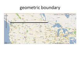
Examples of geometrical boundaries:
- Rectangular Boundaries: Rectangular boundaries are formed by drawing straight lines to create a rectangular shape. For example, the boundaries of Colorado in the United States are roughly rectangular in shape, as they are formed by straight lines of latitude and longitude.
- Straight-Line Boundaries: Straight-line boundaries are created by drawing straight lines between specific points on the map, regardless of natural or cultural features. The border between the United States and Canada is an example of a straight-line boundary in some areas, such as the border between Minnesota and Manitoba.
- Parallel Boundaries: Parallel boundaries are established by using lines of latitude or longitude as borders. An example of a parallel boundary is the border between Libya and Sudan, which is defined by the 22nd parallel of latitude.
- Meridian Boundaries: Meridian boundaries are created using lines of longitude. The border between Nepal and China (Tibet) follows the 88th meridian east as a boundary line.
- Circular Boundaries: Circular boundaries are drawn as arcs or circles around a specific point. An example is the boundary of Vatican City, which is circular in shape and centered around St. Peter’s Basilica.
- Quadrilateral Boundaries: Quadrilateral boundaries are formed by connecting four specific points to create a four-sided shape. The boundary between Namibia, Zambia, Zimbabwe, and Botswana is an example of a quadrilateral boundary.
It’s important to note that while geometrical boundaries provide a straightforward and easily delineated method for establishing borders, they often do not align with natural or cultural divisions. This can lead to potential challenges, conflicts, and difficulties in governance and administration. Over time, geopolitical factors and agreements may modify or adjust these boundaries to better reflect historical, cultural, and socio-political considerations.
Q. 6 a) “Culture is a dynamic concept”. Elucidate with examples.
b) “Automation is rapidly changing the economies of labour and will affect trade patterns in significance ways”. Clarify.
c) “Over crowding leads to chronic problems of shortage of housing in Indian cities”. Explain citing relevant examples.
Q. 7 a) “Climate change is a serious problem to global food security and poverty eradication”. Critically examine.
Ans: Climate change indeed poses a serious threat to global food security and poverty eradication. The impact of climate change on agriculture and food production is multifaceted and complex, with far-reaching consequences for vulnerable populations, particularly in developing countries.
Let’s critically examine the relationship between climate change, food security, and poverty eradication:
Agriculture and Food Production: Climate change affects agricultural productivity in various ways:
a. Changing Growing Seasons: Altered weather patterns, including shifts in rainfall and temperature, can disrupt traditional growing seasons, affecting crop yields and planting schedules.
b. Extreme Weather Events: Increasing frequency and intensity of extreme weather events, such as droughts, floods, and storms, damage crops, livestock, and agricultural infrastructure, leading to reduced food production and income losses for farmers.
c. Water Scarcity: Climate change can exacerbate water scarcity, which is vital for irrigation and livestock production. Decreased water availability can hinder agricultural productivity and food production in arid and semi-arid regions.
Food Security: Food security is the availability, access, and utilization of sufficient, safe, and nutritious food to meet dietary needs and preferences. Climate change can compromise food security in several ways:
a. Reduced Crop Yields: Climate-induced impacts on crop yields can lead to food shortages and price increases, making nutritious food less accessible, especially for low-income populations.
b. Malnutrition: Climate change affects the nutritional content of crops, reducing the availability of essential micronutrients and exacerbating malnutrition and related health problems.
c. Disruptions in Supply Chains: Extreme weather events and climate variability can disrupt food supply chains, leading to shortages, increased food prices, and food insecurity, especially in vulnerable regions.
Poverty Eradication: Climate change can undermine poverty eradication efforts:
a. Impacts on Livelihoods: For many poor communities, agriculture is a primary source of income and livelihood. Climate change-induced losses in agricultural productivity can push people deeper into poverty.
b. Migration and Displacement: Climate change-induced events, such as droughts and floods, can trigger migration and displacement, leading to the loss of assets and livelihoods for vulnerable populations.
c. Economic Vulnerability: Climate-related shocks can increase economic vulnerability for poor households, making it harder for them to escape poverty or maintain sustainable livelihoods.
Adaptation and Mitigation: While climate change poses significant challenges to food security and poverty eradication, it also presents opportunities for adaptation and mitigation:
a. Adaptation Strategies: Implementing climate-smart agricultural practices, water management, and drought-resistant crop varieties can enhance resilience and food security in the face of climate change.
b. Sustainable Land Management: Encouraging sustainable land and natural resource management can help mitigate climate change impacts and ensure the availability of resources for future generations.
c. Policy Interventions: Effective policies that address climate change, invest in agricultural research and extension services, and promote social safety nets can reduce vulnerabilities and enhance poverty eradication efforts.
In conclusion, climate change poses a serious and complex challenge to global food security and poverty eradication. Its impacts on agriculture, food production, and livelihoods can lead to increased food insecurity and hinder poverty eradication efforts, particularly in vulnerable regions. Addressing climate change and its effects on food security and poverty requires comprehensive and coordinated efforts at the global, national, and local levels to promote sustainable and resilient agricultural practices, invest in social safety nets, and foster climate adaptation and mitigation strategies.
b) Critically examine the significance of the Quantitative Revolution and its influence in the development of Geography.
Ans: The Quantitative Revolution was a significant development in the field of geography during the mid-20th century. It represented a shift from descriptive and qualitative approaches to a more quantitative and analytical approach to studying geographical phenomena. The emergence of the Quantitative Revolution had both positive and negative impacts on the development of geography.

Let’s critically examine its significance and influence:
- Positive Aspects:
a. Rigor and Precision: The Quantitative Revolution brought rigor and precision to geographical research. By emphasizing empirical data collection and statistical analysis, geographers could quantify and measure various spatial patterns and relationships. This led to more reliable and replicable research outcomes.
b. Scientific Advancement: The adoption of quantitative methods aligned geography with other scientific disciplines, such as physics, mathematics, and economics. This interdisciplinary approach fostered new insights and allowed geographers to address complex problems in a more systematic manner.
c. Spatial Analysis: The Quantitative Revolution emphasized spatial analysis, enabling geographers to examine spatial distributions, patterns, and processes. This approach provided a deeper understanding of the spatial organization of phenomena and contributed to the development of geographic information systems (GIS) and remote sensing technologies.
d. Predictive Capabilities: The use of quantitative methods allowed geographers to develop models and theories that could predict future spatial patterns and trends. These predictive capabilities are valuable in various fields, including urban planning, environmental management, and resource allocation.
- Negative Aspects:
a. Reductionism: Critics argue that the emphasis on quantitative methods may lead to reductionism, where complex geographical phenomena are oversimplified or reduced to numerical values, overlooking important qualitative aspects and local contexts.
b. Neglect of Human Geography: The Quantitative Revolution initially focused more on physical geography and neglected human geography. Human geographical phenomena, such as culture, politics, and social dynamics, were not easily quantifiable, limiting their exploration within the quantitative paradigm.
c. Data Limitations: Quantitative approaches heavily rely on data availability, accuracy, and relevance. In some regions or topics, data might be scarce or of poor quality, limiting the application of quantitative methods and potentially leading to biased conclusions.
d. Ethical Considerations: Some quantitative research may overlook ethical considerations, especially when dealing with human subjects and sensitive issues. There is a risk of reducing individuals and communities to mere data points without understanding their lived experiences.
- Evolution and Integration:
Over time, geography has evolved to embrace both quantitative and qualitative methodologies, recognizing the strengths and limitations of each approach. The quantitative and qualitative methods have been integrated, leading to a more holistic and comprehensive understanding of geographical phenomena.
In conclusion, the Quantitative Revolution had a significant influence on the development of geography, introducing a more scientific and analytical approach to the discipline. It facilitated spatial analysis, predictive capabilities, and interdisciplinary research. However, it also faced criticisms for reductionism, neglect of human geography, and data limitations. The subsequent evolution and integration of quantitative and qualitative methodologies have enriched geographical research, allowing geographers to tackle complex issues more effectively and providing a more comprehensive understanding of the world’s diverse landscapes and human-environment interactions.
c) Explain in detail the impact of regional disparities on economic development.
Ans: Regional disparities refer to the differences in economic development, prosperity, and living standards between different regions within a country or across countries. These disparities can have significant impacts on economic development and have wide-ranging social, political, and economic implications. Let’s delve into the detailed impact of regional disparities on economic development:
- Unequal Distribution of Resources: Regional disparities often arise due to variations in the distribution of resources such as natural resources, infrastructure, human capital, and economic opportunities. Regions with abundant resources and favorable conditions tend to attract investment, generate higher incomes, and experience faster economic growth, while regions with limited resources face challenges in development.
- Economic Productivity and Growth: Regional disparities can hinder overall economic productivity and growth. When certain regions lag behind in terms of development, their productivity levels may be lower due to limited access to capital, technology, skilled labor, and markets. This can lead to suboptimal utilization of resources and a drag on overall economic performance.
- Income Inequality: Regional disparities often contribute to income inequality within a country. Disadvantaged regions with lower incomes and limited employment opportunities struggle to provide adequate livelihoods for their populations, leading to income disparities between regions. Income inequality can have adverse social consequences, including reduced social mobility, increased poverty rates, and social tensions.
- Migration and Brain Drain: Regional disparities can trigger internal migration, as individuals seek better economic opportunities and living conditions in more developed regions. This migration can exacerbate disparities, as human capital and skilled labor concentrate in economically advanced areas, leading to a phenomenon known as “brain drain.” The outflow of talent and skilled workers from disadvantaged regions can hinder their capacity for economic growth and development.
- Social and Political Instability: Persistent regional disparities can fuel social and political instability. Disadvantaged regions may experience higher levels of social unrest, discontent, and political conflicts as residents perceive an unfair distribution of resources and opportunities. This instability can further hamper economic development by discouraging investment, disrupting infrastructure development, and impeding policy implementation.
- Unequal Access to Services: Regional disparities often result in unequal access to essential services such as healthcare, education, infrastructure, and public utilities. Disadvantaged regions may face challenges in providing quality education and healthcare facilities, limiting human capital development and reducing productivity. Unequal access to infrastructure and utilities hinders business activities, inhibits market integration, and constrains economic growth.
- Spatial Imbalances: Regional disparities can lead to spatial imbalances, where certain regions become dominant economic centers, while others remain marginalized. Concentration of economic activities in specific regions can result in overcrowding, strain on infrastructure, environmental degradation, and increased socio-economic divides. These spatial imbalances hinder sustainable and balanced regional development.
Addressing Regional Disparities: To mitigate the negative impacts of regional disparities and foster balanced economic development, policymakers can implement various strategies:
- Invest in infrastructure and human capital development in disadvantaged regions.
- Promote regional economic diversification and industry clusters.
- Provide targeted incentives and subsidies to attract investment in less developed regions.
- Improve access to quality education and healthcare services in disadvantaged areas.
- Enhance transportation and connectivity between regions to facilitate trade and integration.
- Implement regional development policies and programs that focus on reducing disparities and promoting inclusive growth.
Addressing regional disparities requires a comprehensive and coordinated approach involving government policies, public-private partnerships, and community participation. By reducing regional disparities, countries can foster sustainable and inclusive economic development, enhance social cohesion, and create opportunities for all citizens.
Q. 8 a) How migration is affected by push and pull factors? Explain how these factors play a role in understanding new settlement patterns.
Ans: Migration is influenced by a combination of push and pull factors. Push factors refer to conditions or circumstances in the origin region that encourage or force individuals to leave, while pull factors are factors in the destination region that attract migrants. These factors play a significant role in shaping migration patterns and understanding new settlement patterns. Let’s explore how push and pull factors contribute to migration and settlement decisions:
Push Factors:
- Economic Push Factors: Lack of job opportunities, low wages, economic instability, poverty, and limited access to resources can push individuals to seek better economic prospects in other regions or countries.
- Social and Political Push Factors: Political instability, social unrest, persecution, discrimination, violence, or lack of personal safety can motivate people to migrate to escape unfavorable social or political conditions.
- Environmental Push Factors: Environmental factors like natural disasters, climate change, drought, famine, or ecological degradation can force individuals to leave their homes in search of safer and more sustainable living conditions.
- Demographic Push Factors: Overpopulation, high population density, or demographic imbalances can create pressure on resources and opportunities, leading people to migrate in search of better living conditions.
Pull Factors:
- Economic Pull Factors: Availability of job opportunities, higher wages, better living standards, access to resources, and economic stability attract migrants to regions with stronger economies and greater employment prospects.
- Social and Cultural Pull Factors: Access to better education, healthcare, social services, cultural amenities, and improved quality of life can act as pull factors for migrants seeking an enhanced social environment.
- Political and Legal Pull Factors: Political stability, peace, security, and favorable legal frameworks, such as relaxed immigration policies or pathways to citizenship, can attract migrants seeking stability and security.
- Environmental Pull Factors: Favorable environmental conditions, including a pleasant climate, fertile land, and natural resources, can draw migrants to regions with more favorable living environments.
Understanding New Settlement Patterns: Push and pull factors contribute to the formation of new settlement patterns by influencing the decisions of migrants regarding their destination. When push factors outweigh pull factors, migration tends to occur from areas with unfavorable conditions to regions with better prospects. The interplay between push and pull factors can create specific migration corridors or routes, leading to the concentration of migrants in particular destinations.
The settlement patterns emerging from migration reflect the cumulative impact of push and pull factors. Migration can result in the formation of ethnic enclaves, diaspora communities, or new urban centers with diverse cultural influences. Over time, these settlement patterns may evolve as migrants establish social networks, contribute to local economies, and influence the cultural landscape of their new destinations.
Understanding push and pull factors helps policymakers, urban planners, and researchers comprehend the dynamics of migration and plan for the social, economic, and infrastructural needs of migrant populations. By addressing push factors in origin regions and enhancing pull factors in destination regions, policymakers can work towards creating more balanced and inclusive settlement patterns that benefit both migrants and host communities.
Q. 8 b) Explain the relevance and applicability of Von Thunen theory of Agriculture-location in today’s world.
Ans: The Von Thünen model of agricultural location, despite being developed in the 19th century, still holds relevance and provides valuable insights into the spatial organization of agricultural activities in today’s world. While the model may not fully capture the complexities of modern agricultural systems, it offers some applicable concepts and considerations.
Here are some reasons why the Von Thünen model remains relevant today:
- Market Proximity: The model’s emphasis on the proximity to markets as a key factor in agricultural location decisions is still valid. Proximity to consumers is crucial for minimizing transportation costs, accessing markets efficiently, and reducing spoilage or loss of perishable goods. This is particularly relevant in local and regional food systems, where consumers prioritize locally produced and fresh products.
- Transportation Costs: Von Thünen’s model underscores the significance of transportation costs in agricultural location decisions. While modern transportation technologies have evolved, transportation costs remain a key consideration for farmers. High transportation costs can affect profitability, especially for bulky or perishable goods. The model’s insight into the trade-off between land rent and transportation costs can still inform decisions about the allocation of agricultural activities across different regions.
- Land Rent and Land Use Intensity: The model’s concept of a land rent gradient, with lower land rent further away from the market, can be applicable today. Farmers consider land rent as a factor in deciding what crops to cultivate and how intensively to use the land. The model’s idea of concentric rings with different land use intensities can still provide insights into the spatial distribution of agricultural activities, considering factors such as irrigation availability, land fertility, and labor costs.
- Local and Niche Agriculture: Von Thünen’s model focused on the production of staple crops, but it can also be applied to understand the location of niche and specialized agricultural activities. Today’s agricultural systems encompass various specialized production methods, including organic farming, agroforestry, and high-value horticulture. The model’s concept of market gardening and dairying close to urban centers aligns with the proximity requirements of niche markets and direct-to-consumer sales.
- Land-Use Planning and Policy: The Von Thünen model’s insights can inform land-use planning and policy decisions. Understanding the spatial distribution of agricultural activities helps in developing effective strategies for rural development, infrastructure investments, and preserving agricultural land. It can guide decisions on zoning regulations, preservation of peri-urban agricultural areas, and balancing agricultural production with environmental conservation objectives.
However, it is important to recognize the model’s limitations and consider the changes in agriculture since its development. Modern agricultural systems involve factors such as global markets, advancements in technology, specialized supply chains, and non-agricultural land uses. These factors may challenge the simplicity of the model, and it is necessary to complement its insights with contemporary data, empirical studies, and advanced analytical tools for a comprehensive understanding of agricultural location dynamics.
In conclusion, while the Von Thünen model may not fully capture the complexities of today’s agricultural systems, it still provides valuable concepts and considerations for understanding agricultural location decisions, transportation costs, market proximity, and land use intensity. Its relevance lies in its ability to offer insights into the fundamental economic principles that continue to shape agricultural landscapes in various parts of the world.
c) Discuss the concept of ‘Rank-Size-Rule’ given by G. K. Zipf. Is this rule relevant in Indian context?
Ans: The Rank-Size Rule, formulated by G. K. Zipf, is an empirical observation about the relationship between the rank and size of cities or urban areas within a country or region. It states that the population of a city is inversely proportional to its rank in the urban hierarchy. In other words, the second-largest city is typically half the size of the largest city, the third-largest city is one-third the size of the largest city, and so on.
The Rank-Size Rule can be expressed mathematically as follows:
P = a / R
Where:
- P represents the population of a city,
- R represents the rank of the city in the urban hierarchy, and
- ‘a’ is a constant that may vary depending on the specific context.
According to Zipf’s observation, when cities are ranked in descending order of population, the relationship between population and rank follows a power-law distribution. This means that the population of a city is approximately proportional to the inverse of its rank raised to some exponent.
![]()
Zipf’s Rank-Size Rule has been found to hold true in many countries and regions, although with some variations and deviations. It is often observed that the largest city in a country has a disproportionately larger population compared to the smaller cities. However, as the rank decreases, the difference in population between cities becomes less pronounced.
The Rank-Size Rule has important implications for urban planning, regional development, and economic analysis. It suggests that larger cities tend to have a greater concentration of economic activities, infrastructure, and services, making them attractive centers of commerce, culture, and innovation. However, the rule also highlights the potential challenges of urbanization, such as overcrowding, inadequate infrastructure, and disparities in resource distribution between larger and smaller cities.
While the Rank-Size Rule provides a useful framework for understanding urban hierarchies, it is important to note that it is an empirical observation and does not account for all factors that influence urban growth and population distribution. Factors such as historical, cultural, political, and geographical factors can also play a significant role in shaping the size and distribution of cities within a region.
In the case of India, the Rank-Size Rule exhibits certain limitations and deviations from the idealized pattern observed in some other countries. India is a diverse and complex nation with a unique set of historical, cultural, and economic factors that shape urban development.
While the largest cities in India, such as Mumbai, Delhi, and Kolkata, do have significantly larger populations compared to smaller cities, the deviation from the Rank-Size Rule becomes more evident as we move down the urban hierarchy. India has a vast number of smaller towns and cities with relatively high populations, challenging the strict inverse relationship between population and rank suggested by the Rank-Size Rule.
The deviations from the Rank-Size Rule in the Indian context can be attributed to several factors, including historical legacies, patterns of rural-urban migration, government policies, and regional disparities. For example, historically significant cities, cultural centers, and administrative capitals have maintained their prominence and population size, irrespective of their rank in the urban hierarchy.
Additionally, rapid urbanization in India has led to the growth of many smaller cities and towns with substantial populations due to factors like employment opportunities, regional development initiatives, and infrastructure investments. These cities contribute significantly to the overall urban population, challenging the strict applicability of the Rank-Size Rule.
It is important to recognize that while the Rank-Size Rule provides a useful framework for understanding urban hierarchies, it is a simplified model that may not fully capture the complex dynamics and variations in urban development within a country like India. Therefore, while the Rank-Size Rule can offer insights into the population distribution of Indian cities, it should be used in conjunction with other analytical tools and considerations to gain a comprehensive understanding of urban patterns in India.
