Ice (like glaciers), wind, and sea waves also play a big role in changing the Earth’s surface. These natural forces do three main things:
- Erosion: They wear down rocks and soil.
- Transportation: They carry the broken material from one place to another.
- Deposition: They drop the material in new places, usually in lower areas.
Together, these actions help smooth out the land and reduce high and low areas. In this article, we’ll learn how each of these forces works and what kinds of landforms they create.
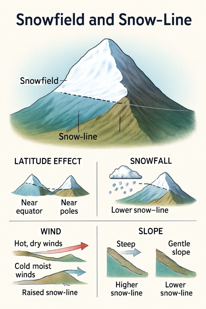
Table of Contents
Snowfields and the Snow-Line
In places where it’s always cold, snow doesn’t melt—it keeps building up. Over time, this snow becomes thick and turns into ice. These areas are called snowfields. They are always found above a certain height called the snow-line.
- A snowfield is a place always covered in snow and ice.
- The snow-line is the lowest level where snow stays all year.
- The height of the snow-line depends on temperature, snowfall, wind, and slope.
The snow-line is the lowest point where snow stays all year. But this height changes depending on a few things:
- Latitude: Near the equator (hotter areas), the snow-line is higher. Near the poles (colder areas), it’s lower—sometimes at sea level.
- Snowfall: If more snow falls than melts, the snow-line is lower.
- Wind: Hot, dry winds melt snow quickly, raising the snow-line. Cold, moist winds help snow stay, lowering it.
- Slope: On steep slopes, snow slides off easily, so the snow-line is higher. On gentle slopes, snow stays longer, so the snow-line is lower.
In super cold places, it snows all the time—and that snow doesn’t melt much. Instead, it builds up year after year and turns into thick ice. These permanently frozen areas are called snowfields. But snowfields only form above a certain height, called the snow-line. Think of it as the “magic line” on mountains above which snow stays all year.
What Is a Glacier?
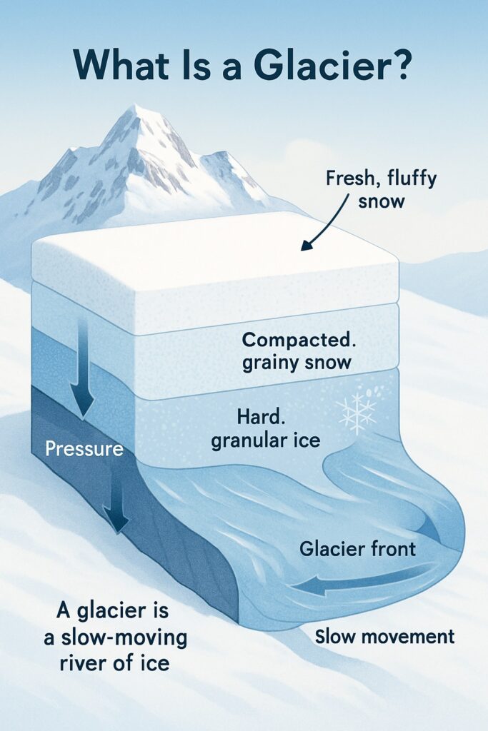
In snowy regions, fresh snow keeps building up in layers year after year. The weight of these layers squashes the snow at the bottom, making it hard, grainy, and compact. This process even melts some snow, which refreezes and turns into granular ice.
Eventually, this huge, solid mass of ice becomes a glacier—a slow-moving river of ice! It flows downhill under its own weight, but at a very slow pace—just a few centimeters to a few meters per day.
Types of Glaciers
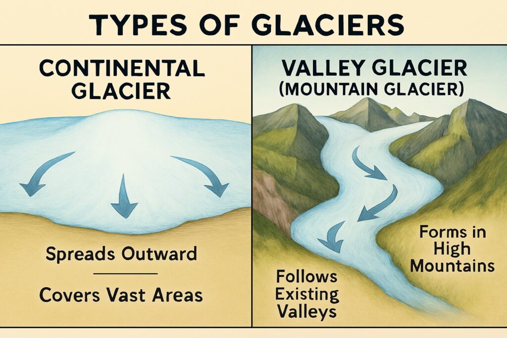
There are two main types of glaciers, depending on where they form:
Continental Glaciers
- Huge ice sheets that cover vast areas.
- They form in cold regions like Antarctica and Greenland.
- These glaciers build up in the center and spread outward in all directions.
- They can be thousands of meters thick!
Valley Glaciers
- These form in high mountains.
- Ice starts flowing down existing valleys—fitting their shape.
- In wide valleys, glaciers spread out.
- In narrow valleys, they squeeze and move like toothpaste from a tube!
Examples from India
- Siachen Glacier in the Karakoram range — about 72 km long.
- Gangotri Glacier in Uttarakhand — 25.5 km long.
- Rivers like the Ganga and Yamuna begin from glaciers: Gangotri and Yamunotri.
How Glaciers Shape the Land
Just like rivers, glaciers perform three major jobs: erosion, transportation, and deposition. Even though they move slowly and affect smaller areas, glaciers leave BIG marks on the land!
Erosion by Glaciers
As glaciers flow over land, they pick up rocks, gravel, and sand. These materials act like tools that scrape and scratch the surface beneath—almost like a giant icy bulldozer! Here are the main landforms created by this erosive action:
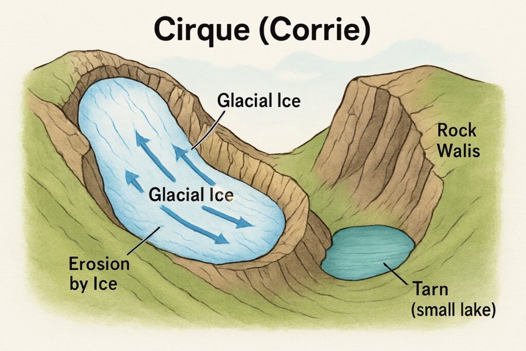
Cirque
- A bowl-shaped hollow found at the start of a glacier.
- It forms where ice collects and digs into the rock.
- Sometimes, water fills this hollow later—creating a small lake called a tarn.
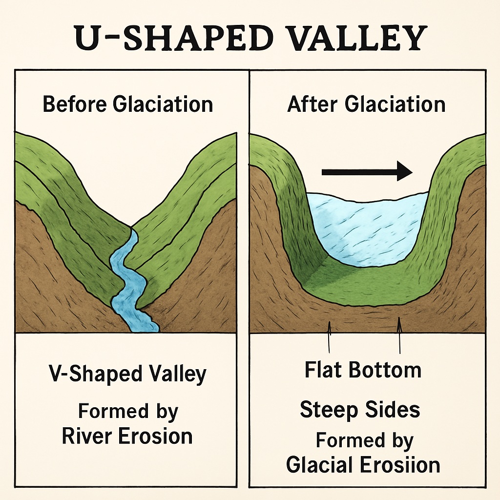
U-Shaped Valley
- Unlike rivers that carve V-shaped valleys, glaciers reshape existing valleys.
- They make the valley deeper, wider, and smoother—resulting in a shape like the letter “U.”
- These valleys have flat bottoms and steep, straight sides.
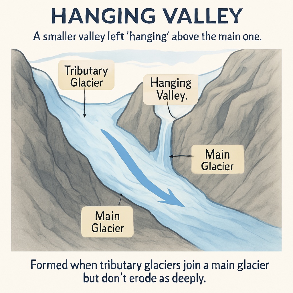
Hanging Valley
- Small glaciers (called tributary glaciers) join the larger main glacier.
- But they don’t erode as deeply, so their valleys are higher up.
- After the ice melts, these high-up valleys look like they’re “hanging” above the main one.
How Glaciers Carry and Deposit Material
Glaciers may be slow movers, but they’re mighty transporters! As they slide downhill, they pick up everything from tiny grains to huge boulders. This load of rocks and soil is called the glacial load, and it comes from:
- Mountain slopes
- Valley sides
- Valley floor
- Even the air!
Transportation by Glaciers
Glaciers gather and drag this rocky material as they move. It’s like an icy conveyor belt, shifting chunks of the landscape from one place to another.
Deposition by Glaciers
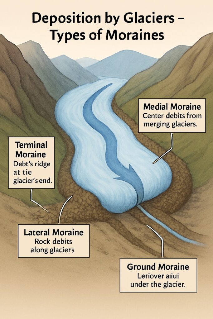
When glaciers melt or pull back (called retreating), they drop their load in different spots. These leftovers form piles called moraines. Depending on where they’re placed, moraines are grouped into four types:
Terminal Moraine
- Found at the very end of the glacier.
- Looks like a ridge made of clay, gravel, and boulders.
Lateral Moraine
- Found along the sides of the glacier.
- Made from debris fallen from valley walls.
Medial Moraine
- Created when two glaciers meet and their side moraines merge.
- Forms a dark line running down the center of the combined glacier.
Ground Moraine
- Found underneath the glacier.
- A mix of fine and coarse material left behind after the glacier melts.
How Wind Shapes the Land
Wind is a powerful sculptor in dry regions like deserts. Since there’s little vegetation and lots of loose soil, the wind gets plenty of material to work with. It performs the classic trio of:
- Erosion: Breaking rocks into smaller pieces
- Transportation: Carrying those pieces away
- Deposition: Dropping them when the wind slows down
Erosion by Wind
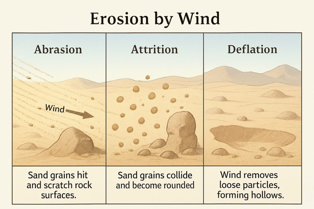
Wind erosion happens mostly with the help of sand particles. These tiny grains act like sandpaper and wear down rocks. It works in three ways:
- Abrasion – Sand grains hit and scratch surface rocks, slowly wearing them away.
- Attrition – Sand particles crash into each other, getting rounder and smoother.
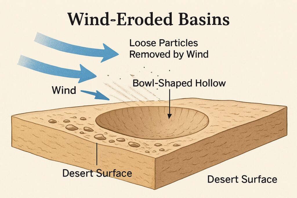
- Deflation – Wind blows away loose particles from the ground, creating hollows.
Landforms from Wind Erosion
Let’s look at a few special shapes the wind creates:
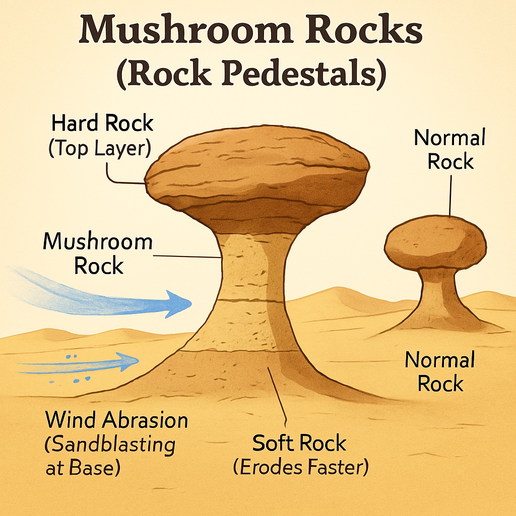
Mushroom Rocks (Rock Pedestals)
- Rocks with layers—some hard, some soft.
- Wind erodes the softer lower part faster, leaving the top like a wide cap.
- Result: rocks shaped like mushrooms!
- Seen in Sahara Desert and near Jodhpur in India.
Wind-Eroded Basins
- Strong wind blows away small particles from dry ground.
- Over time, it creates bowl-shaped hollows or basins.
- Famous example: Quattara Depression in Egypt.
How Wind Moves and Drops Sand and Dust
We’ve already seen how wind breaks things down. Now let’s explore how it carries and drops materials to reshape the land.
Transportation by Wind
Wind can carry all kinds of tiny things:
- Dust, smoke, pollen, fine sand, even seeds.
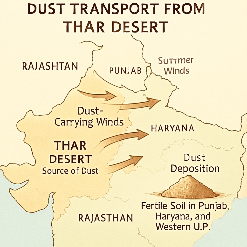
- In dry areas with loose soil and no trees, wind lifts loads of particles.
- These can travel very far—even hundreds or thousands of kilometers!
Examples:
- Wind from the Gobi Desert carries dust all the way to northern China.
- In India, winds from the Thar Desert bring dust to Western Uttar Pradesh, Haryana, and Punjab, making soil fertile there.
Deposition by Wind
Eventually, the wind drops what it’s carrying. This happens when:
- Wind is overloaded with dust.
- Wind slows down and loses strength.
- Wind hits an obstacle (like a bush or rock) and has to rise over it—slowing down and dropping particles.
Landforms Made by Wind Deposition
Let’s look at some cool shapes formed when wind drops sand:
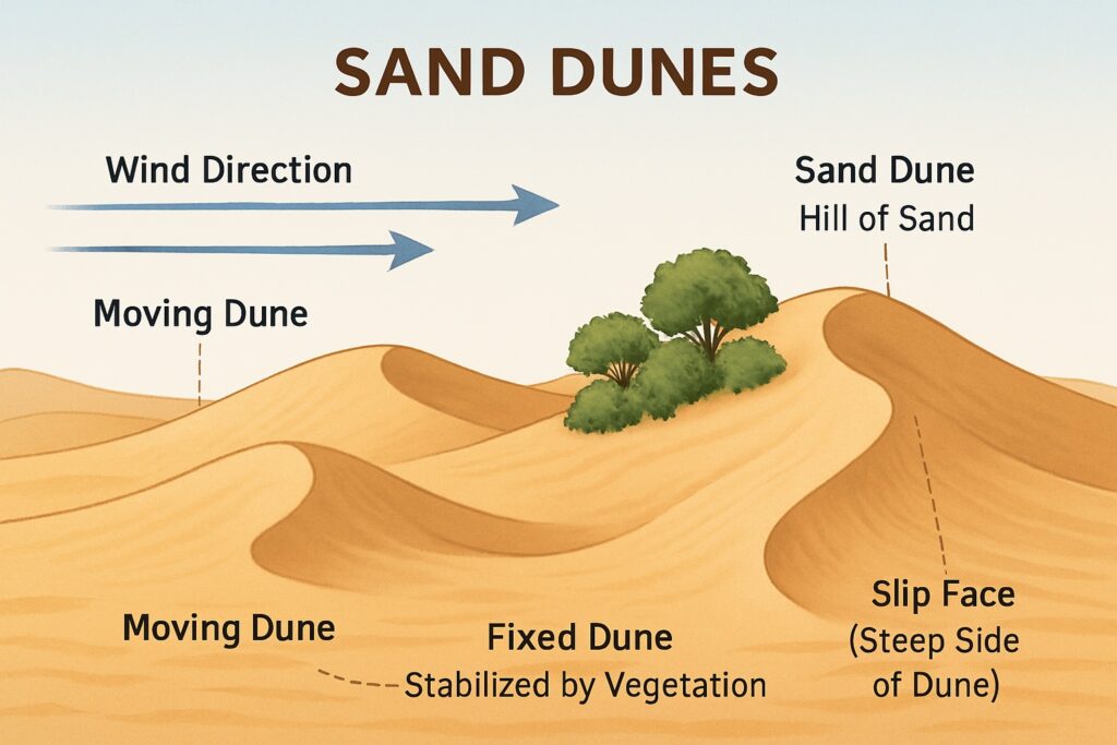
Sand Dunes
- Hills made of sand—common in deserts.
- They can move or stay still, depending on wind and obstacles.
- If bushes or trees grow, the dunes become fixed and stop moving.
There are two main types:
Barkhans
- Crescent-shaped dunes.
- Form when sand piles up behind an obstacle.
- Found in places with strong one-direction winds, like the Sahara Desert.
Seif Dunes
- Long, narrow ridges running parallel to wind direction.
- Made when swirling winds deposit sand along the sides of open spaces.
- Seen in the Thar Desert.
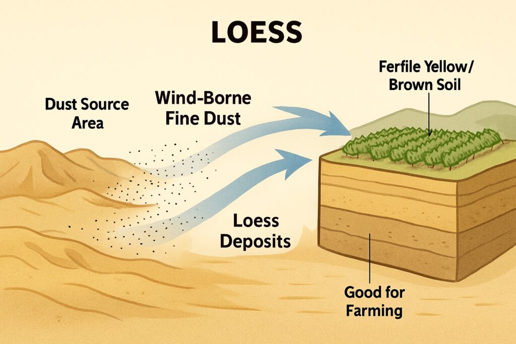
Loess
- Fine dust deposited far from its source.
- Looks like yellow or brown soil—great for farming!
- Major deposits found in Northern China, Germany, and parts of India.
- The Yellow River in China gets its name from this yellow dust!
How Sea Waves Shape the Land
Sea waves are always in motion, especially near coastlines. Like rivers and glaciers, they perform the three familiar tasks:
- Erosion – Breaking down rocks
- Transportation – Carrying broken pieces
- Deposition – Dropping materials to form new landforms
Waves help reshape coastlines by wearing away rocky areas and building up new coastal features.
Erosion by Sea Waves
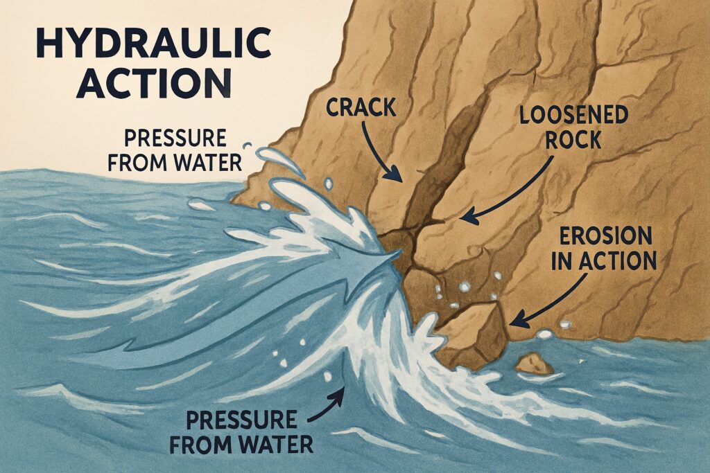
Sea water filled with sand and rock pieces hits the coast and breaks down rocks using four key processes:
- Abrasion – Waves carrying sand and pebbles scrape against rocks.
- Attrition – Rock fragments smash into each other and become smoother and smaller.
- Hydraulic Action – Cracks and holes in coastal cliffs get widened by water pressure.
- Solution – Sea water dissolves soft rocks like limestone.
The strength of wave erosion depends on:
- The force and size of the waves
- The shape and slope of the coastline
- The type of rock (soft rocks erode faster)
- Tides, rainfall, and even plant and animal activity
Landforms Created by Wave Erosion
Here are some cool coastal features formed when waves do their sculpting:
Sea Cliff
- Waves erode the bottom of coastal rocks more than the top.
- Eventually, the upper part collapses, leaving a tall vertical wall called a cliff.
- Found along India’s Konkan Coast.
Sea Caves
- When soft rock at the bottom of cliffs erodes, hollows form.
- With time and pressure, these hollows become caves.
Sea Arches
- If waves cut through a rock projection from two sides, a hole forms.
- That hole widens and becomes a natural arch or bridge.
Sea Stacks
- If the top of an arch collapses, the leftover part stands alone as a stack.
- Smaller underwater ones are called stumps.
How Sea Waves Transport and Deposit Materials
Waves don’t just break things down—they also carry and drop materials. This constant motion helps shape the coastline in fascinating ways.
Transportation by Sea Waves
Waves, tides, and ocean currents move debris from place to place. The two key ways this happens:
- Sea to Shore – Waves bring things like shells, conches, and other ocean items onto the coast.
- Shore to Sea – Waves carry soil, sand, and bits of rock away from the land into the ocean.
So yes, waves act like busy couriers—picking up, moving, and setting down all kinds of natural cargo!
Deposition by Sea Waves
When waves lose energy—say near the coast or due to slower currents—they drop what they’re carrying. This deposition builds beautiful features along the shoreline. Let’s look at a few:
Beach
- Made of sand, gravel, and shells dropped by waves.
- This flat area near the sea becomes a perfect spot to relax and play.
- Famous Indian beaches: Marina Beach in Chennai, Kovalam Beach in Thiruvananthapuram.
Sand Bar
- A ridge of sand and gravel that lies between the shore and the sea.
- It can block boats from entering easily—a natural barrier.
Spit
- Like a sand bar, but only one end is attached to the coast.
- The other end stretches out into the sea, forming a narrow finger of land.
Lagoon
- Sometimes a sand bar completely encloses part of the sea water.
- This creates a shallow salty lake near the coast.
- Famous Indian lagoons: Chilika Lake, Pulicat Lake, and Vembanad Lake.
Read: Geography Notes