Polycyclic landforms are landscapes that have undergone multiple cycles of erosion and uplift. These cycles occur over long geological time scales and are typically caused by changes in climate, sea levels, or tectonic movements. As a result, the landforms display features from different geomorphic periods, making them valuable records of Earth’s dynamic history. These landforms typically exhibit a combination of different erosion and deposition processes, leading to their unique and intricate shapes.
"The term polycyclic indicates that these landforms have undergone several cycles of erosion, sedimentation, and weathering"
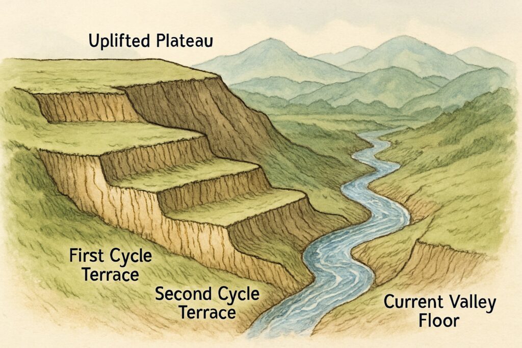
Table of Contents
The Process of Polycyclic Transformation
The formation of polycyclic landforms begins with an initial phase of uplift or subsidence that creates a new landscape. This initial landform is then modified, or “rejuvenated,” by erosion. Over time, as the region experiences further uplift, changes in base level (such as sea level fluctuations) or alterations in climatic conditions, additional cycles of erosion modify the existing landforms.
Each cycle may refine the earlier features while introducing new ones, such as fresh terraces or incised valleys. The interaction of these cycles results in landscapes where older, heavily weathered surfaces sit beneath younger.
"Polycyclic Landforms are the result of interruption in the fluvial cycle of erosion."
Mechanisms of Formation of Polycyclic Landforms
Several processes contribute to the development of polycyclic landforms:
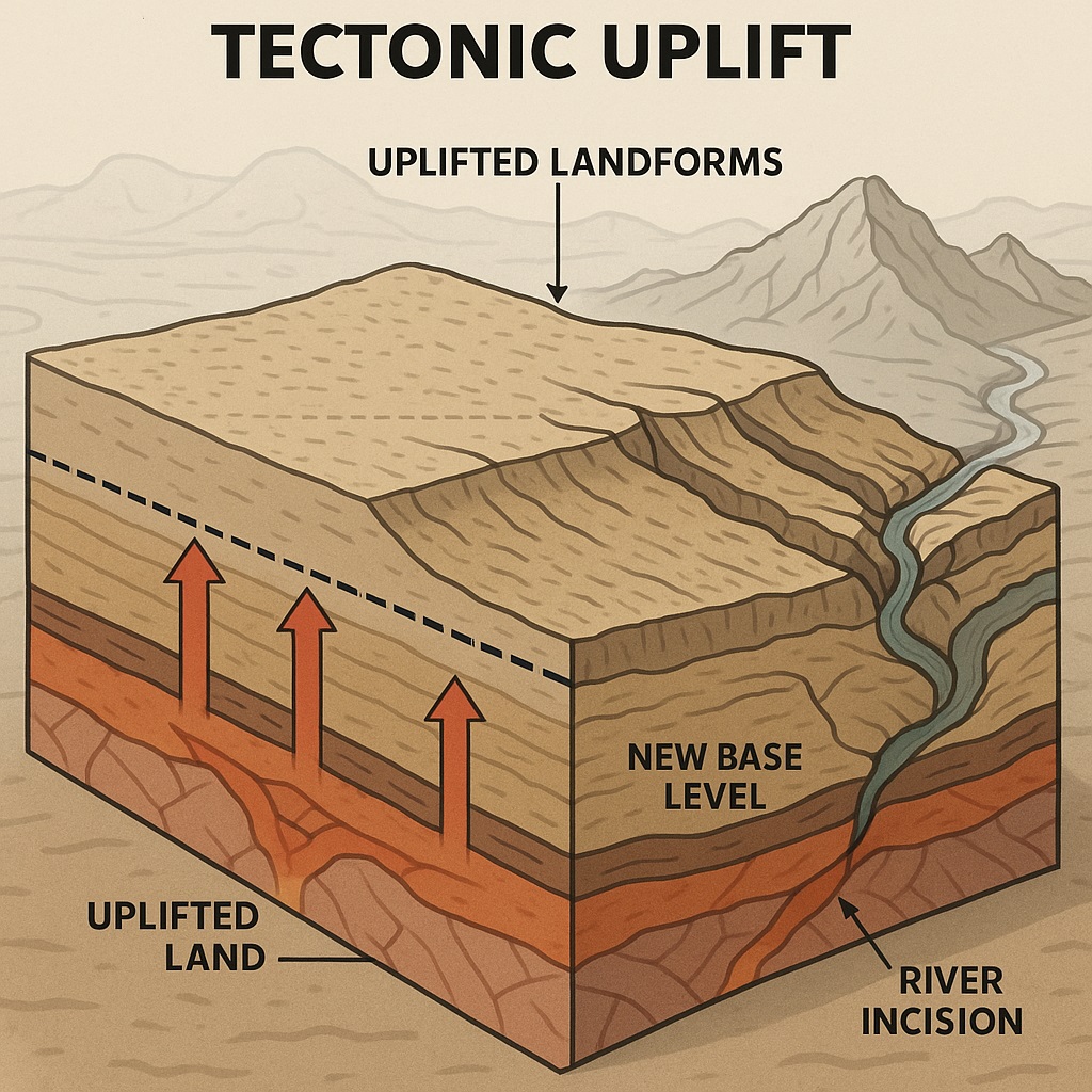
Tectonic Uplift
The earth’s crust may undergo episodes of uplift due to plate tectonics or orogenic events. With each uplift, previously established landforms are set at a new base level and subjected to additional erosional forces.
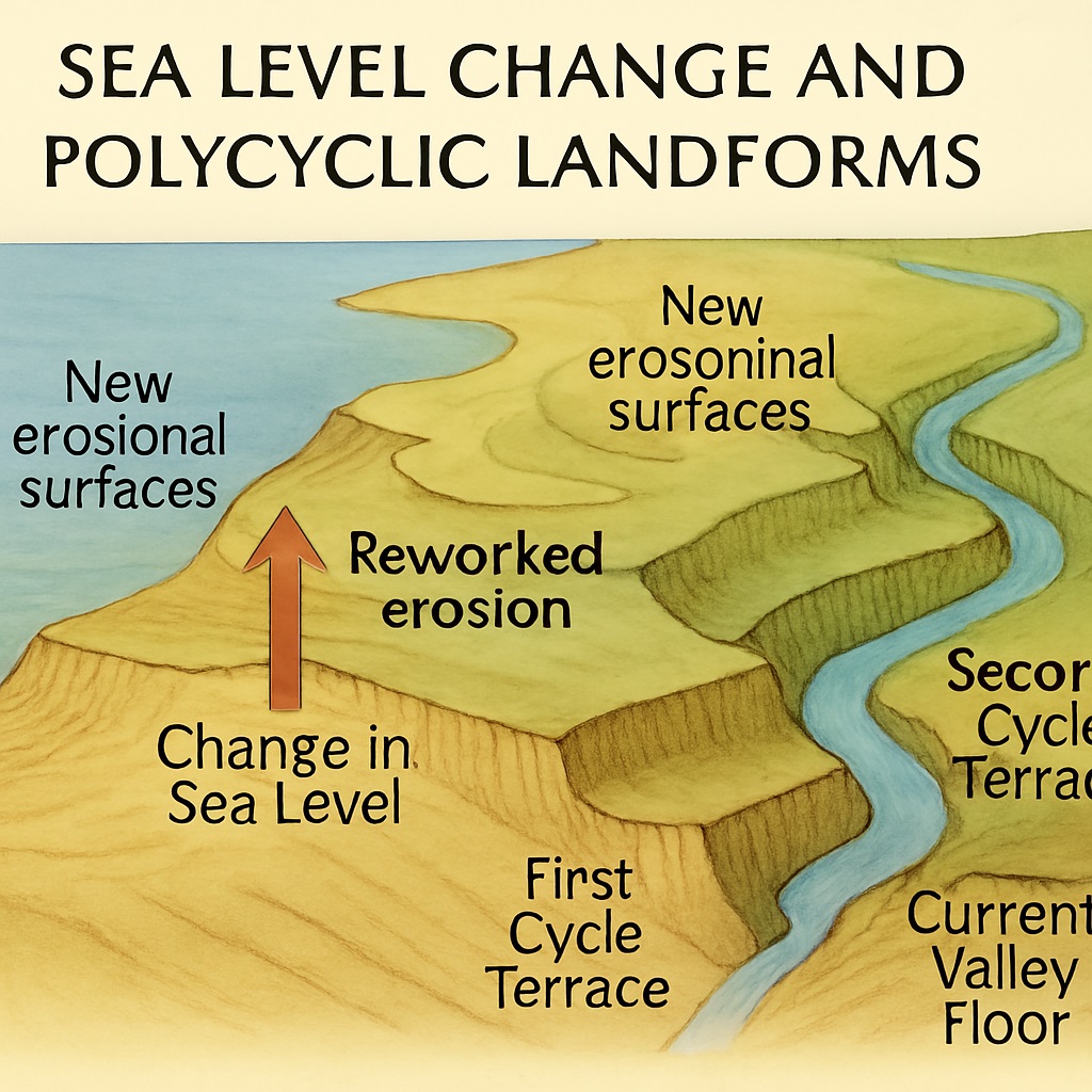
Sea-Level Changes
Global or regional changes in sea level, whether due to eustatic (global) factors like glaciation or localized subsidence, can alter the erosion patterns along coastlines and fluvial systems. These changes create new erosional surfaces or rework existing ones.
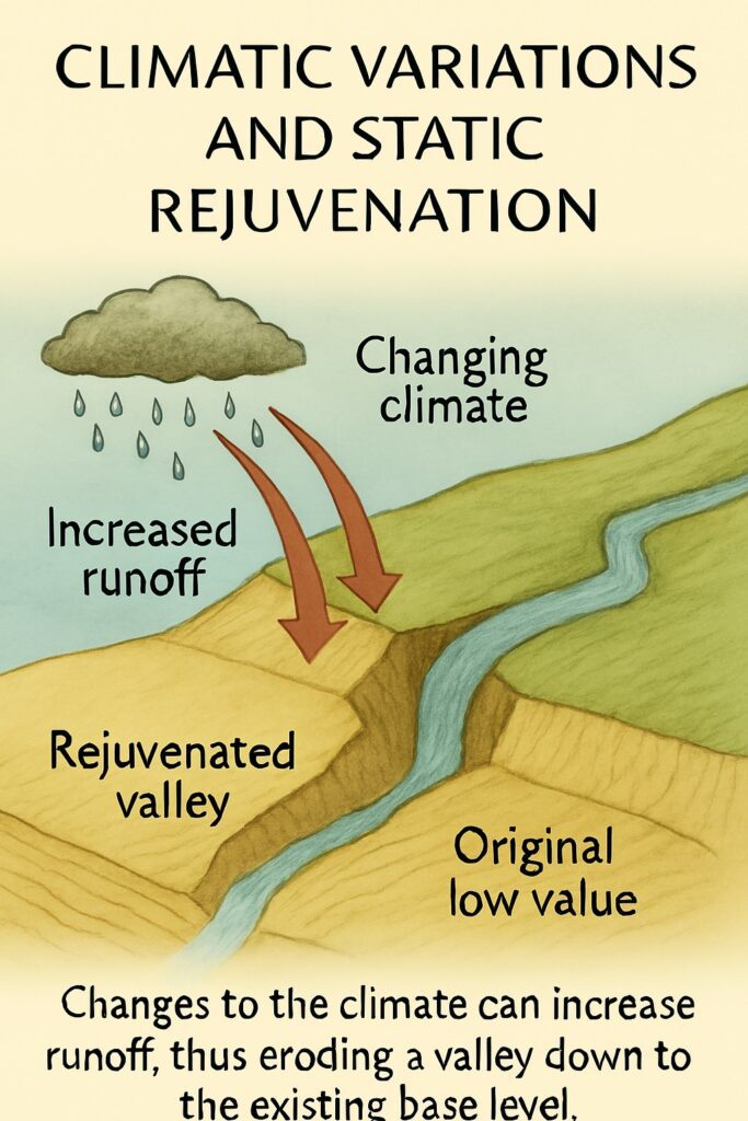
Climatic Variations and Static Rejuvenation
Shifts in climate, such as periods of increased aridity or heavy rainfall, influence the rate and type of erosion. In addition, changes in river dynamics—such as increased water volume from heightened precipitation—can accelerate downcutting, leading to the formation of features like incised meanders and knickpoints (breaks in the slope of a river’s longitudinal profile).
Examples of Polycyclic Landforms
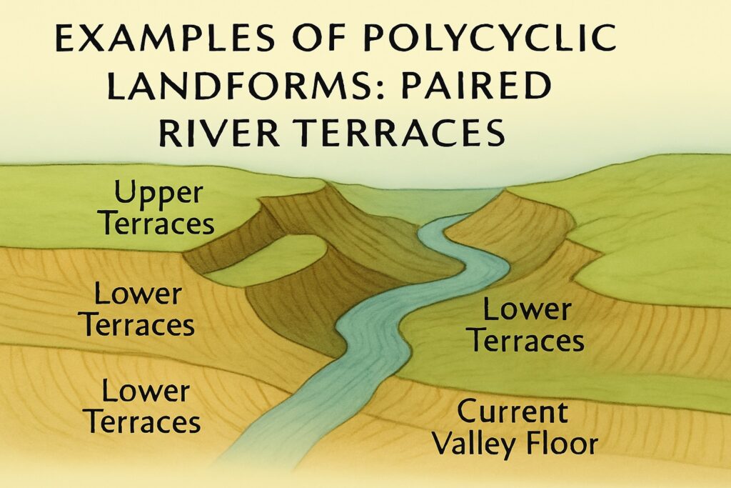
Paired River Terraces
Paired river terraces are the example of topographical discordance. They are a geomorphic feature commonly found in fluvial landscapes. They consist of two distinct levels of elevated landforms or terraces on both sides of a river valley, appearing like a set of steps or platforms. Paired river terraces form due to changes in the river’s base level or variations in its erosional and depositional processes over time.
The formation and preservation of paired river terraces provide valuable insights into the geological history of a region. They often represent a record of past river behavior, tectonic activity, and changes in base level. Geomorphologists study paired river terraces to understand landscape evolution, past climate conditions, and the interactions between rivers and tectonic processes.
Uplifted Peneplain
An uplifted peneplain is a geomorphic feature that represents an ancient, nearly flat land surface that has been uplifted and exposed due to tectonic forces or other geological processes. Peneplains are characterized by their low relief and extensive erosion, and they are considered to be mature landscapes resulting from prolonged weathering and erosion over millions of years.
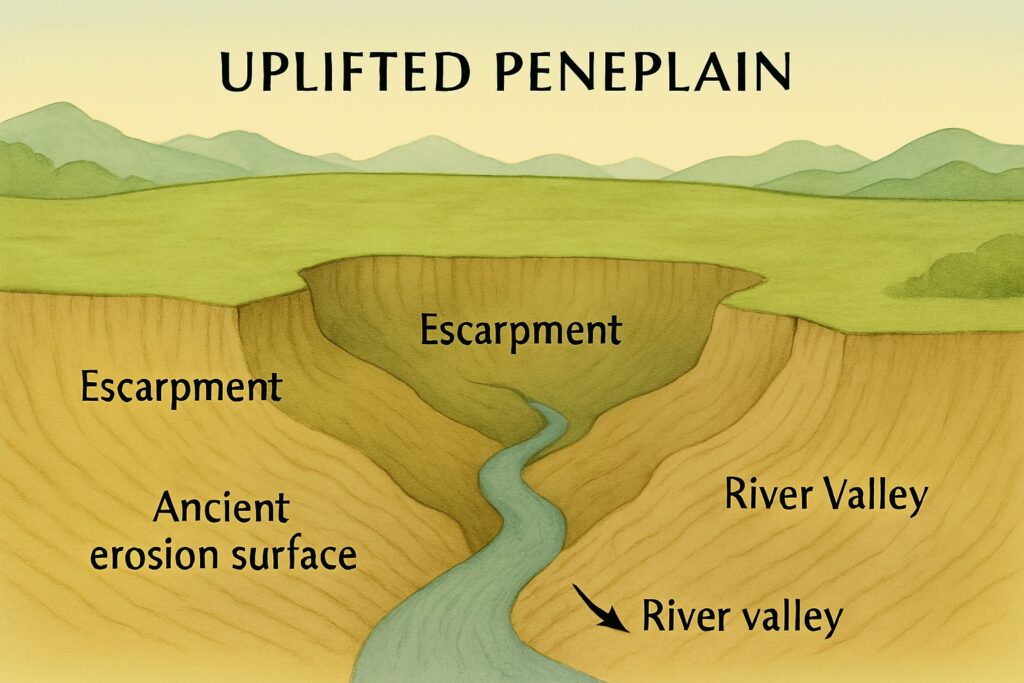
The formation of an uplifted peneplain involves the following processes:
- Peneplanation: Peneplanation is the process of extensive erosion that gradually wears down a region to form a nearly flat or gently undulating surface. This process typically occurs over long periods of time, as running water, glaciers, and other erosional agents work to smooth the landscape, reducing sharp relief features.
- Tectonic Uplift: While the peneplain is being created through erosion, tectonic forces, such as regional uplift, can raise the entire region. This uplift may be due to tectonic plate movements, faulting, or other geological processes that elevate the landmass.
- Incision and Uplift: Following the tectonic uplift, rivers and other erosional agents begin to incise into the uplifted peneplain, carving valleys and creating new relief features. The once nearly flat surface is dissected, and the uplifted peneplain is exposed at higher elevations.
- Exhumation: The process of exposing the uplifted peneplain through incision and erosion is known as exhumation. Over time, the river valleys deepen, and the peneplain is revealed as terraces or remnants at higher elevations above the current river level.
Incised Meanders
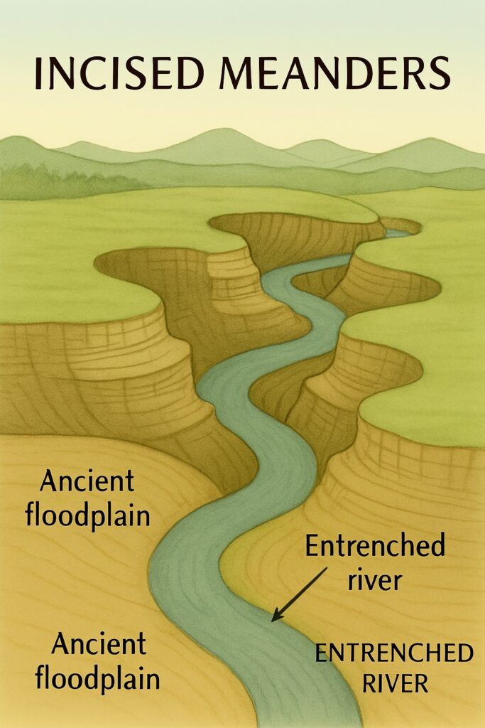
The formation of incised meanders involves the following processes:
- Erosion: Initially, a river meanders across a relatively flat floodplain, and the flow of water erodes the outer bank (the concave bank of the meander) through a process called lateral erosion. This results in the widening of the meander loop.
- Meander Migration: Over time, the river may undergo lateral migration, meaning the meander loops gradually shift their positions on the floodplain. The river erodes the outer banks of the meanders and deposits sediment on the inner banks (the convex bank of the meander).
- Base Level Lowering: The incision of meanders occurs when there is a lowering of the base level, which is the lowest point to which a river can erode. This can be caused by tectonic uplift of the surrounding area or a drop in sea level. As the base level drops, the river responds by downcutting or eroding its channel vertically to adjust to the new lower level.
- Erosion and Incision: As the river downcuts, it erodes the bedrock or sediment, deepening the channel, and creating steep canyon-like walls. The original meander bends become “incised” into the landscape at a higher elevation than the present-day floodplain.
- Terrace Formation: As the river downcuts, it may leave behind remnants of the old floodplain as terraces or elevated flat surfaces. These terraces represent the former level of the floodplain before the incision occurred.
Incised meanders are commonly found in areas where the landscape has experienced tectonic uplift or changes in sea level. These features are essential for understanding the geological history of a region, as they provide insights into past river behavior, tectonic activity, and climate changes. The process of incised meander formation is ongoing, and rivers can continue to incise their channels if the base level continues to lower or the tectonic uplift persists.
Knick Point
A Knick point is a sharp, abrupt change in the longitudinal profile of a river or stream, where there is a sudden drop in elevation or steepening of the river gradient. It is also known as a “nickpoint” or “cascade.” Knickpoints are significant geomorphic features that often indicate an area of active erosion and river channel adjustment.
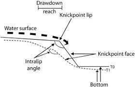
The formation of a Knick point is associated with the following processes:
- Differential Erosion: Different rock types or geological formations can have varying resistance to erosion. When a river encounters a transition from more erodible rocks to more resistant rocks, it can lead to differential erosion. The softer rocks erode more quickly, causing a sudden change in the river’s gradient at that location.
- Base Level Change: Knick points can also form when the base level of the river changes. Base level is the lowest point to which a river can erode, usually the level of a lake, sea, or ocean where the river ultimately discharges. If the base level drops (e.g., due to tectonic uplift or a drop in sea level), the river responds by adjusting its profile, creating a Knick point as it erodes downward to reach the new base level.
- Tectonic Uplift: Tectonic forces can uplift the landscape, leading to the rapid uplift of a river’s course. The river then responds by down cutting its channel to adjust to the new elevation, creating a Knick point in the process.
Knick points are dynamic features that can migrate upstream or downstream over time as the river continues to adjust its profile through erosion. They play a crucial role in landscape evolution, as they contribute to the shaping of valleys, canyons, and gorges.
Significance in Earth Sciences
Studying polycyclic landforms is vital for geologists and geomorphologists for several reasons:
- Historical Reconstruction: The stratification and morphology of polycyclic landscapes enable scientists to reconstruct the sequence of tectonic, climatic, and sea-level events that have shaped a region. This, in turn, contributes to our broader understanding of Earth’s evolution.
- Natural Resource Exploration: Many polycyclic regions contain valuable mineral deposits. The processes that create these landscapes also concentrate ores and other resources, making them important for economic geology.
- Risk Assessment: Understanding the legacy of tectonic uplift and erosion can inform assessments of geological hazards such as landslides, erosion rates, and sedimentary basin development—all critical factors in land-use planning and infrastructure development.
Examples of Polycyclic Landforms in India
-
River Terraces: Paired terraces along river valleys, such as those in Uttarakhand, India, reflect multiple phases of uplift and river incision.
-
Alluvial Terraces: Older alluvium terraces (e.g., Bhangar in the north Indian plains) are remnants of earlier cycles of deposition and erosion.
-
Rejuvenated Valleys: Multi-layered valleys like the Damodar Valley and the Ranchi plateau (“Patland”) show evidence of successive erosional cycles and uplift.
-
Erosional Surfaces: The Appalachian Mountains and the Western Ghats display surfaces of different ages due to repeated cycles of uplift and erosion.
-
Plateaus and Pediments: Elevated flat-topped areas and gently sloping surfaces formed by repeated cycles of erosion and sedimentation.
-
Karst and Glacial Landscapes: Karst features (sinkholes, caves) and glacial valleys can also be polycyclic if subjected to multiple cycles of dissolution or glaciation.
Read: Geography Notes