India exhibits remarkable physical diversity, with a landscape shaped by a complex geological history. The country’s structure and relief are primarily the result of the tectonic collision between the Indian Plate and the Eurasian Plate, leading to the formation of various landforms ranging from lofty mountains to coastal plains. The Indian subcontinent can be divided into five major physiographic divisions, each with distinct geological and structural features.
Table of Contents
1. The Northern Mountains (Himalayas)
- Formation: Formed by the convergence of the Indian and Eurasian tectonic plates about 50 million years ago.
- Extent: Stretches over 2,400 km from Jammu & Kashmir in the west to Arunachal Pradesh in the east.
- Subdivisions:
- Greater Himalayas (Himadri): Tallest ranges, includes Mt. Everest, Kanchenjunga.
- Lesser Himalayas (Himachal): Moderate height; includes hill stations like Shimla, Mussoorie.
- Shiwaliks: Outer Himalayas; formed of unconsolidated sediments.
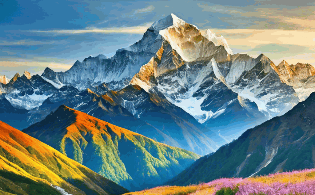
-

Greater Himalaya Image Significance: Acts as a climatic barrier, source of perennial rivers, and home to biodiversity and tourism.
2. The Indo-Gangetic Plains
- Location: Lies south of the Himalayas, stretching from Punjab to Assam.
- Formation: Formed by the deposition of alluvium brought by rivers like the Ganga, Indus, and Brahmaputra.
- Characteristics:
- Extremely fertile and flat terrain.
- One of the most densely populated and agriculturally productive regions.
- Divided into three sections:
- Punjab Plains (west)
- Ganga Plains (central)
- Brahmaputra Plains (east)
3. The Peninsular Plateau
- Geological Age: One of the oldest landmasses, formed during the Precambrian era.
- Structure: Composed of hard igneous and metamorphic rocks.
- Divisions:
- Central Highlands: Between the Vindhya and Aravalli ranges.
- Deccan Plateau: South of the Narmada River, bounded by the Western and Eastern Ghats.
- Features:
- Rich in minerals.
- Contains important river valleys (Godavari, Krishna).
- Presence of lava plateaus like the Malwa Plateau and Karnataka Plateau.
4. The Coastal Plains
- Location: Narrow plains lying along the Arabian Sea (west) and Bay of Bengal (east).
- Divisions:
- Western Coastal Plain: Narrow and steep, includes Konkan, Kannad, and Malabar coasts.
- Eastern Coastal Plain: Broader, includes Northern Circars and Coromandel Coast.
- Features:
- Presence of estuaries (west) and deltas (east) like the Mahanadi and Godavari deltas.
- Rich in agriculture, fisheries, and port development.
5. The Islands
- Andaman and Nicobar Islands: Located in the Bay of Bengal, volcanic origin, rich in biodiversity.
- Lakshadweep Islands: Coral atolls and reefs in the Arabian Sea.
- Significance: Strategic for national security, tourism, and marine biodiversity.
Geological Structure of India
- Tectonic Zones:
- Himalayan Belt: Tectonically active, frequent earthquakes.
- Peninsular Shield: Stable block, geologically ancient.
- Indo-Gangetic Trough: A foreland basin formed due to Himalayan uplift.
- Major Geological Formations:
- Archean Rocks: Found in Karnataka, Tamil Nadu, Jharkhand.
- Vindhyan System: Mainly sedimentary rocks, found in central India.
- Gondwana Rocks: Contain coal deposits, found in Madhya Pradesh, Jharkhand.
Conclusion
The structure and relief of India not only define the country’s topography but also influence its climate, vegetation, population distribution, and economic activities. From the mighty Himalayas to the fertile plains and the ancient plateaus, India’s physical diversity reflects a long and dynamic geological history that continues to shape the subcontinent even today.
Read: Geography Notes