Class 11 Geography NCERT Solutions Chapter 7 Landforms and their Evolution
1. Multiple choice questions.
(i) In which of the following stages of landform development, downward cutting is dominated?
(a) Youth stage
(c) Early mature stage
(b) Late mature stage
(d) Old stage
Ans: (a) Youth stage
Explanation: During the youth stage of landform development, the dominant geomorphic process is downward cutting, often driven by the erosional activity of rivers or streams. In this stage, landforms are characterized by the initial shaping and carving of valleys and canyons through the removal of rock and soil materials.
(ii) A deep valley characterized by steep step-like side slopes is known as
(a) U-shaped valley
(c) Blind valley
(b) Gorge
(d) Canyon
Ans: (b) Gorge
Explanation: A gorge is a deep and narrow valley with steep, almost vertical sides that often have a series of step-like slopes. Gorges are typically formed by the erosional activity of rivers or other geological processes, and they can create dramatic and striking landscapes.

(iii) In which one of the following regions is the chemical weathering process more dominant than the mechanical process?
(a) Humid region
(c) Arid region
(b) Limestone region
(d) Glacier region
Answer: (b) Limestone region
Explanation: Limestone is a rock primarily composed of calcium carbonate, which is susceptible to chemical weathering, particularly through processes like dissolution and carbonation. In limestone regions, the chemical breakdown of calcium carbonate by water and weak acids is more prominent than mechanical weathering, leading to the formation of various karst landscapes, such as caves, sinkholes, and limestone pavements. While mechanical weathering does occur, the unique properties of limestone make chemical weathering more dominant in shaping the landscape of limestone regions.
(iv) Which one of the following sentences best defines the term ‘Lapies’?
(a) A small to medium sized shallow depression
(b) A landform whose opening is more or less circular at the top and funnel-shaped towards the bottom
(c) A landform formed due to dripping water from the surface
(d) An irregular surface with sharp pinnacles, grooves, and ridges
Ans: (c) A landform formed due to dripping water from the surface
Explanation: Lapies, also known limestone pavement, is a type of landform that develops on the surface of limestone rock due to the dissolution and erosion caused by dripping water. Over time, the dripping water creates channels, grooves, and small depressions, resulting in a distinctive and characteristic surface pattern.

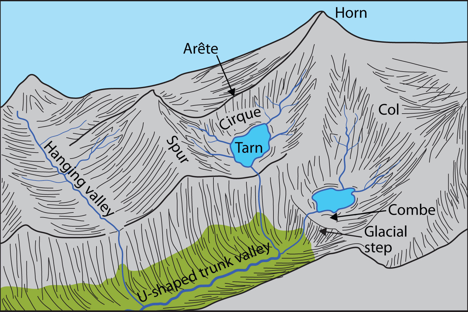
(v) A deep, long, and wide trough or basin with very steep concave high walls at its head as well as on its sides is known as:
(a) Cirque
(c) Lateral Moraine
(b) Glacial valley
(d) Esker
Ans: (a) Cirque
Explanation: A cirque is a glacial landform characterized by a deep, amphitheater-like basin with steep, concave high walls. It is often found at the head of a glacial valley, where glacial erosion has excavated the rock and created a hollow depression. The steep walls of the cirque are a result of glacial ice carving and eroding the surrounding rock. Over time, these cirques can become the starting points for glaciers or glacial lakes.
2. Answer the following questions in about 30 words.
(i) What do incised meanders in rocks and meanders in plains of alluvium indicate?
Answer: Incised meanders in rocks indicate the down-cutting and rejuvenation of a river’s course, often due to uplift or changes in base level. Meanders in alluvial plains signify lateral erosion and deposition, shaping the river’s path and the surrounding landscape.
(ii) Explain the evolution of valley sinks or uvalas.
Answer: Valley sinks, or uvalas, form in karst landscapes through a series of processes. Initial dolines (sinkholes) develop due to limestone dissolution by water. These sinkholes can coalesce over time, creating a larger, more extensive depression known as a uvala. Water infiltrates through openings, further dissolving the limestone, and contributing to the growth of these distinctive landforms.
(iii) Underground flow of water is more common than surface run-off in limestone areas. Why?
Answer: Limestone is a soluble rock that readily dissolves in water, creating underground channels, caves, and conduits through a process called karstification. These conduits provide efficient pathways for water to flow underground, often resulting in greater underground flow compared to surface run-off in limestone areas.
(iv) Glacial valleys show up many linear depositional forms. Give their locations and names.
Answer: Glacial valleys exhibit various linear depositional forms. Moraines, such as lateral and terminal moraines, are commonly found along the sides and ends of glacial valleys. Drumlins, elongated hills made of glacial till, are prominent in areas shaped by glaciers, such as northern Europe and North America.
(v) How does wind perform its task in desert areas? Is it the only agent?
Answer: Wind is a significant force shaping desert landscapes through erosional processes like deflation and abrasion. Deflation involves the removal of loose particles, such as sand and dust, gradually altering the surface elevation and leading to the formation of desert pavement. Abrasion, driven by wind-borne particles, smoothens and sculpts rock surfaces over time, resulting in distinctive features like mushroom rocks.
3. Answer the following questions in about 150 words.
(i) Running water is by far the most dominating geomorphic agent in shaping the earth’s surface in humid as well as in arid climates. Explain.
Answer: Running water is a dominant geomorphic agent in both humid and arid climates due to its powerful erosional and depositional capabilities. In humid regions, abundant rainfall and surface runoff lead to the formation of intricate drainage patterns, valleys, and river networks through processes like erosion, transportation, and deposition. In arid areas, even though water is scarce, intermittent heavy rainfall can result in flash floods that cause rapid erosion, carving out arroyos and canyons. The sporadic nature of precipitation magnifies the impact of water in reshaping the arid landscape.
(ii) Limestones behave differently in humid and arid climates. Why? What is the dominant and almost exclusive geomorphic process in limestone areas and what are its results?
Answer: Limestones, being soluble in water, undergo distinct processes in different climates. In humid climates, abundant water promotes chemical weathering and dissolution of limestone, creating underground caves, sinkholes, and karst topography. In arid climates, infrequent but intense rainfall also accelerates dissolution due to the concentrated water flow.
The dominant geomorphic process in limestone areas is karstification, primarily driven by chemical weathering. Rainwater, enriched with carbon dioxide, forms weak carbonic acid that dissolves limestone. This leads to the creation of various karst features, such as caverns, sinkholes, disappearing streams, and unique surface landscapes called uvalas.
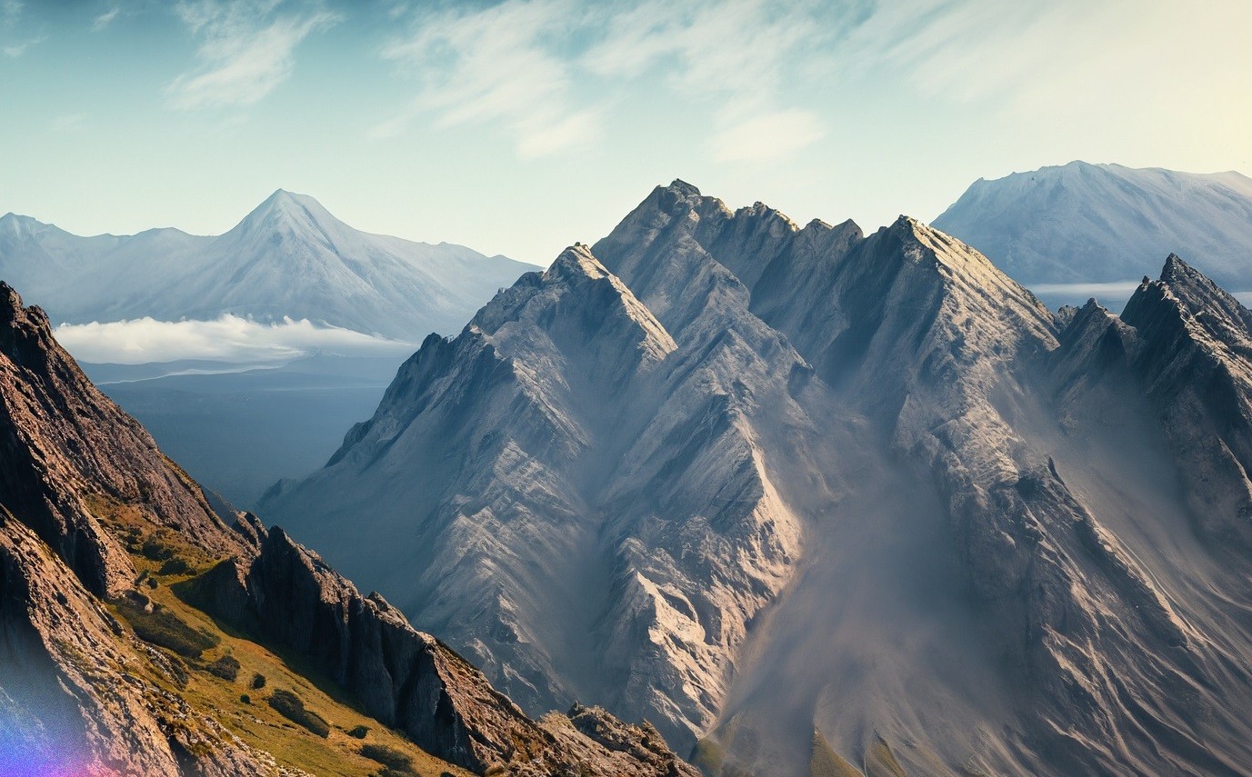
(iii) How do glaciers accomplish the work of reducing high mountains into low hills and plains?
Answer: Glaciers are massive bodies of ice that slowly move under their weight, exerting powerful erosional forces on the landscape. As glaciers flow downhill, they pick up rocks, debris, and soil, acting as immense bulldozers that scrape and gouge the underlying rock. This process, known as glacial erosion, carves U-shaped valleys, fjords, and cirques in high mountains. The ice also entrains sediments, grinding and pulverizing rocks into fine glacial till. As glaciers melt, they deposit this till as moraines, outwash plains, and drumlins, thereby reshaping high mountain terrain into lower hills and plains over geological timescales.
Thanks for reading this article on Class 11 Geography NCERT Solutions Chapter 7

Read