Group-A (Attempt any 10 out of 12 | Word Limit: 250 | Marks: 15 each)
1. Elucidate the regional disparities in the distribution of mineral resources in India. How do you bring equitable development to that scenario taking Odisha as an example?
Answer India exhibits significant regional disparities in mineral resource distribution, creating a complex geographical pattern of resource endowment and developmental inequality. The mineral-rich regions are primarily concentrated in the eastern and central parts of the country, particularly in the Chota Nagpur Plateau, which encompasses parts of Jharkhand, Odisha, Chhattisgarh, and West Bengal. This region contains approximately 70% of India’s coal reserves, substantial iron ore deposits, bauxite, and other metallic minerals.
The peninsular shield, being geologically ancient, hosts most of India’s metallic minerals, while the Indo-Gangetic plains and coastal regions are relatively mineral-poor but agriculturally rich. This creates a paradox where mineral-rich states often lag in human development indices despite their resource wealth.
Odisha exemplifies this contradiction perfectly. The state contributes nearly 24% of India’s coal production, 50% of iron ore, and significant quantities of bauxite, chromite, and manganese. However, it ranks poorly in human development indicators, with high poverty rates and inadequate infrastructure in mineral-rich districts.
Strategies for Equitable Development in Odisha:
- Industrial cluster development with mandatory local employment quotas
- Skill development centers aligned with mining and metallurgical industries
Revenue-sharing mechanisms where mining royalties fund local development projects - Transportation infrastructure connecting mineral areas to markets
- Downstream processing industries to add value locally
- Special economic zones around mineral hubs
- Environmental regulations with community participation
- Allied sector employment in logistics and services
These measures ensure that resource extraction translates into sustainable local development rather than merely benefiting external stakeholders.
2. Comment on the linking of rivers in India with special reference to Odisha. What are the sustainable measures that need to be taken for water resource management in India?
Answer: The National River Linking Project (NRLP) represents India’s ambitious attempt to address water scarcity and flood management through inter-basin water transfers. This mega-project envisages linking 30 rivers through a network of 3,000 storage structures and 10,000 km of canals, aiming to transfer water from surplus basins to deficit regions.
Odisha’s Role in River Linking:
Odisha occupies a strategic position in the eastern component of NRLP. The Mahanadi-Godavari Link is proposed to transfer surplus water from Mahanadi basin, while the Subarnarekha-Mahanadi connection would facilitate water sharing between basins. The state’s coastal canal system aims to link multiple east-flowing rivers for flood mitigation, particularly addressing recurring floods in the Mahanadi delta. Additionally, the project seeks to ensure water security in western Odisha’s chronic drought-prone areas through improved drought management.
However, Odisha faces significant challenges, particularly interstate water disputes with Chhattisgarh over Mahanadi waters, which complicates the linking process and raises questions about equitable water distribution.
Sustainable Water Resource Management Measures:
India requires a comprehensive approach emphasizing watershed management through catchment area treatment and soil conservation. Rainwater harvesting and decentralized storage systems at community levels can enhance local water security. Groundwater recharge through artificial recharge structures, combined with regulated extraction, is crucial for aquifer sustainability.
Agricultural water efficiency through drip irrigation and sprinkler systems can significantly reduce consumption. Wastewater treatment and recycling systems for urban and industrial water, along with river restoration focusing on ecological flow maintenance and pollution control, are essential. Reviving traditional water systems like tanks and stepwells, implementing rational water pricing, establishing river basin authorities for integrated management, and developing climate-resilient infrastructure represent a holistic approach that emphasizes local solutions over large-scale transfers while ensuring environmental sustainability and community participation.
3. Examine the influence of tropical cyclones and western disturbances on rainfall distribution in India. How does climate change affect India’s rainfall patterns? Discuss.
Answer: India’s rainfall distribution is significantly influenced by tropical cyclones and western disturbances, which create distinct regional and seasonal precipitation patterns across the subcontinent.
Tropical Cyclones and Rainfall Distribution:
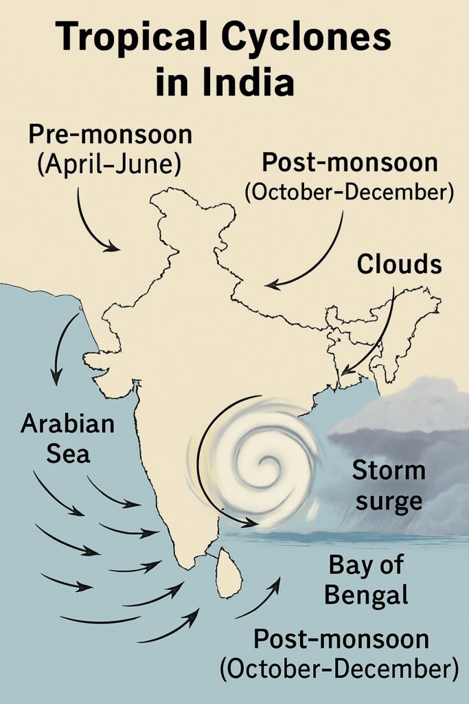
Tropical cyclones originating from the Bay of Bengal and Arabian Sea contribute substantially to India’s annual precipitation. The Bay of Bengal cyclones are more frequent and intense, affecting the eastern coastal states including West Bengal, Odisha, Andhra Pradesh, and Tamil Nadu. These cyclones typically occur during pre-monsoon (April-May) and post-monsoon (October-December) periods, bringing heavy rainfall and often causing devastating floods. The northeast monsoon is particularly dependent on cyclonic activity, with Tamil Nadu receiving nearly 60% of its annual rainfall during this period.
Arabian Sea cyclones, though less frequent, significantly impact the western coastal regions of Gujarat, Maharashtra, Karnataka, and Kerala. The landfall intensity and track of these cyclones determine the spatial distribution of associated rainfall, often extending benefits to interior regions through moisture penetration.
Western Disturbances and Rainfall Patterns:
Western disturbances are extra-tropical cyclones originating from the Mediterranean Sea and Caspian Sea regions, traveling eastward along the subtropical westerly jet stream. These systems are crucial for winter rainfall in north and northwest India, particularly affecting Jammu & Kashmir, Himachal Pradesh, Uttarakhand, Punjab, Haryana, and western Uttar Pradesh.
These disturbances bring rabi crop-sustaining rainfall during December to March, contributing 15-20% of annual precipitation in the Indo-Gangetic plains. The orographic effect of the Himalayas enhances precipitation, causing heavy snowfall in higher elevations and moderate rainfall in the plains. Western disturbances also trigger thunderstorms and hailstorms, creating localized high-intensity precipitation events.
Climate Change Impacts on India’s Rainfall Patterns:
Climate change is fundamentally altering India’s traditional rainfall patterns through multiple mechanisms. Global warming is increasing sea surface temperatures, leading to more intense cyclones with higher precipitation rates but potentially reduced frequency. The monsoon circulation is becoming more erratic, with increasing instances of extreme rainfall events and prolonged dry spells within the same season.
Spatial redistribution of rainfall is evident, with central India experiencing declining trends while extreme northern and southern regions show increasing precipitation. Urban heat islands are intensifying localized convection, leading to flash floods in metropolitan areas. Himalayan warming is affecting western disturbance intensity and frequency, potentially reducing winter rainfall in northwest India.
Monsoon onset timing is becoming increasingly unpredictable, with delayed arrivals and early withdrawals affecting agricultural planning. Increased atmospheric moisture content due to warming is causing cloudbursts and extreme precipitation events, while simultaneously creating longer drought periods due to circulation changes.
The Indian Ocean Dipole and El Niño-Southern Oscillation interactions with climate change are creating compound effects, making seasonal rainfall prediction more challenging and increasing agricultural vulnerability across different agro-climatic zones of India.
4. Distinguish between climatic regions and agro-climatic regions in detail. Which one of them will be helpful for regional development in India? Explain with suitable examples.
Answer: Climatic regions and agro-climatic regions represent two distinct approaches to understanding and classifying geographical areas based on environmental parameters, each serving different analytical and developmental purposes.
Climatic Regions – Definition and Characteristics:
Climatic regions are geographical areas classified primarily based on meteorological parameters including temperature, precipitation, humidity, wind patterns, and seasonal variations. These regions follow purely physical criteria without considering human activities or agricultural potential. Koppen’s classification system is the most widely used framework, categorizing regions into tropical, dry, temperate, continental, and polar climates based on temperature thresholds and precipitation patterns.
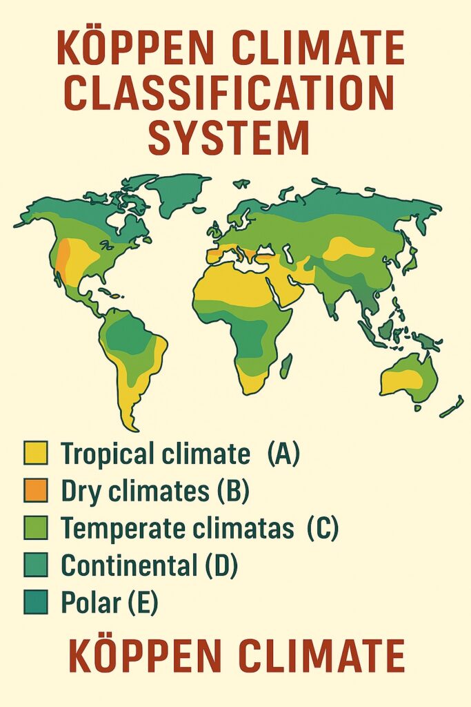
In India, climatic regions include the tropical wet climate of Kerala and coastal Karnataka, tropical monsoon climate of most peninsular India, tropical semi-arid climate of Rajasthan and parts of Gujarat, and subtropical highland climate of the Himalayan regions. These classifications focus on atmospheric conditions and natural weather phenomena without considering land use patterns or economic activities.
Agro-Climatic Regions – Definition and Characteristics:
Agro-climatic regions represent a more comprehensive approach that integrates climatic factors with soil characteristics, topography, water availability, cropping patterns, and agricultural practices. The Planning Commission of India has identified 15 agro-climatic zones based on homogeneity in climate, soil, and water resources to facilitate agricultural planning and rural development.
These regions consider growing seasons, crop suitability, water requirements, soil fertility, and farming systems. For example, the Western Himalayan Region encompasses areas with similar altitude-based farming systems, while the Lower Gangetic Plains Region focuses on rice-wheat cropping patterns and alluvial soil characteristics.
Key Distinctions:
The fundamental difference lies in purpose and application. Climatic regions serve meteorological studies, climate research, and general geographical understanding, while agro-climatic regions are designed for practical agricultural planning, crop selection, and resource allocation. Climatic regions use standardized global criteria, whereas agro-climatic regions employ locally relevant parameters considering human interventions and land use capabilities.
Utility for Regional Development in India:
Agro-climatic regions are significantly more helpful for regional development in India due to their holistic approach and practical applicability. These regions integrate natural endowments with human activities, making them ideal for developmental planning.
Examples of Agro-Climatic Region Benefits:
The Gujarat Plains and Hills Region demonstrates effective utilization of agro-climatic classification. This region’s identification of semi-arid conditions with irrigation potential led to targeted drip irrigation programs, horticulture development, and dairy cooperatives. The White Revolution in Gujarat succeeded because planning recognized the region’s fodder production capacity and water management needs.
The Eastern Plateau and Hills Region covering parts of Jharkhand, Odisha, and Chhattisgarh showcases how agro-climatic planning addresses tribal development. Understanding the region’s forest resources, mineral wealth, and rainfed agriculture potential enabled integrated tribal development programs, forest-based industries, and watershed management projects.
The Trans-Gangetic Plains Region exemplifies agricultural intensification through agro-climatic planning. Recognition of wheat-rice suitability, groundwater availability, and mechanization potential led to Green Revolution success, making this region India’s food bowl.
Limitations of Purely Climatic Approach:
Pure climatic regions would fail to capture these developmental nuances. For instance, the Western Ghats region climatically appears homogeneous with tropical wet conditions, but agro-climatically divides into distinct zones for spice cultivation, plantation crops, hill agriculture, and coastal fishing, each requiring different developmental strategies.
Therefore, agro-climatic regions provide a more realistic framework for regional development by integrating natural conditions with human capabilities and economic potential.
5. Describe the soil types of India in detail. What are the practices adopted in India to conserve soil resources?
Answer: India’s diverse geological formations, climatic conditions, and topographical variations have resulted in a complex mosaic of soil types that fundamentally determine the country’s agricultural productivity and land use patterns.
Major Soil Types of India:
Alluvial soils constitute India’s most extensive and agriculturally significant soil type, covering approximately 40% of the total land area. These soils are primarily found in the Indo-Gangetic Plains, coastal deltas, and river valleys. Old alluvium (Bhangar) forms higher terraces with kankar nodules and lower fertility, while new alluvium (Khadar) occupies floodplains with higher fertility and better moisture retention. These soils are rich in potash but deficient in nitrogen and organic matter, making them ideal for cereal cultivation including rice, wheat, sugarcane, and pulses.
Black cotton soils or Regur soils cover the Deccan Plateau, particularly Maharashtra, Gujarat, Madhya Pradesh, Karnataka, and parts of Andhra Pradesh. Formed from basaltic lava flows, these soils are rich in iron, aluminum, and lime but poor in nitrogen and organic matter. Their high clay content creates swelling and shrinking characteristics, leading to deep cracks during dry seasons and sticky conditions during monsoons. These soils are exceptionally suitable for cotton cultivation and also support jowar, bajra, and sugarcane.
Red and yellow soils developed from crystalline igneous rocks cover the eastern and southern plateaus including parts of Odisha, Chhattisgarh, southern India, and northeastern hills. The red coloration results from iron oxide presence under well-drained conditions, while yellow soils occur in waterlogged areas. These soils are generally acidic, low in fertility, and require fertilizer supplementation for optimal productivity. They support rice, ragi, sugarcane, and plantation crops.
Laterite soils form in regions with high temperature, heavy rainfall, and alternating wet-dry seasons, primarily found in Western Ghats, eastern ghats, Assam, and coastal areas. Intense leaching removes silica and alkalies while concentrating iron and aluminum oxides. These soils become hard and brick-like when exposed but are suitable for plantation crops like cashew, rubber, and spices with proper management.
Arid and desert soils characterize Rajasthan, Gujarat, and Haryana’s dry regions. These sandy soils have low organic content, high salt concentration, and poor water retention capacity. However, they respond well to irrigation and can support drought-resistant crops and pastoral activities.
Mountain soils occur in Himalayan regions and Western Ghats, varying from shallow and stony in higher elevations to fertile valley soils. These soils support terrace cultivation, horticulture, and forest vegetation. Saline and alkaline soils affect approximately 6.73 million hectares, primarily in Punjab, Haryana, Uttar Pradesh, and coastal areas, requiring special reclamation measures.
Soil Conservation Practices in India:
India has implemented diverse soil conservation strategies addressing different types of soil degradation including erosion, salinity, alkalinity, and fertility decline.
Mechanical conservation methods include contour plowing and terrace farming extensively practiced in hilly regions like Himachal Pradesh and Uttarakhand. Bunding and check dams control surface runoff and prevent gully formation. Strip cropping and contour farming are promoted in sloping agricultural lands to reduce soil erosion.
Biological conservation approaches emphasize afforestation and reforestation programs. The National Afforestation Programme and Green India Mission focus on degraded land restoration. Agroforestry systems integrate trees with crops, providing soil protection while generating additional income. Shelter belts and windbreaks prevent wind erosion in arid regions.
Agricultural practices for soil conservation include crop rotation to maintain soil fertility and prevent nutrient depletion. Intercropping and mixed farming reduce monoculture risks and improve soil health. Cover cropping during fallow periods prevents soil exposure and erosion. Green manuring using leguminous crops enhances organic matter and nitrogen content.
Chemical conservation methods involve soil testing programs to determine nutrient requirements and appropriate fertilizer application. Lime application corrects soil acidity, while gypsum treatment addresses alkaline soils. Organic farming initiatives promote compost application, vermicomposting, and biofertilizer usage to improve soil structure and microbial activity.
Government initiatives include the National Mission for Sustainable Agriculture, Pradhan Mantri Krishi Sinchayee Yojana, and Soil Health Card Scheme providing farmers with soil-specific recommendations. Watershed development programs adopt integrated approaches combining water conservation with soil protection across river basins.
These comprehensive measures address India’s soil conservation challenges while maintaining agricultural productivity and environmental sustainability.
6. Analyze the impact of India’s Green, Blue and White revolutions separately. Will an integrated farming bring any new revolution in the future? Discuss.
Answer: India’s agricultural transformation has been shaped by three distinct revolutions that revolutionized different sectors of the economy, each addressing specific challenges and creating profound socio-economic impacts.
Green Revolution Impact Analysis:
The Green Revolution (1960s-1980s) fundamentally transformed India’s food grain production through high-yielding variety seeds, chemical fertilizers, pesticides, and irrigation expansion. This revolution primarily benefited wheat and rice cultivation in Punjab, Haryana, and western Uttar Pradesh.
Positive impacts included achieving food self-sufficiency, increasing wheat production from 11 million tonnes (1960) to 75 million tonnes (1990), and transforming India from a food-importing nation to a food-surplus country. The revolution created employment opportunities in rural areas, improved farmer incomes in adopting regions, and established India as a global food power.
However, negative consequences emerged over time. Environmental degradation through soil depletion, groundwater overexploitation, and pesticide contamination became severe problems. Regional disparities widened as benefits concentrated in irrigated northwestern regions while eastern and southern states lagged behind. Monoculture practices reduced crop diversity, increased pest vulnerability, and neglected nutritious traditional crops. Social inequalities intensified as large farmers benefited disproportionately compared to small and marginal farmers.
Blue Revolution Impact Analysis:
The Blue Revolution focused on fisheries development and aquaculture expansion from the 1980s onwards, transforming India into the world’s second-largest fish producer. This revolution encompassed both marine fisheries and inland aquaculture development.
Significant achievements include increasing fish production from 0.75 million tonnes (1950) to over 14 million tonnes currently, making fisheries a major export sector earning substantial foreign exchange. The revolution created employment for over 16 million people, particularly benefiting coastal communities and rural areas. Aquaculture practices like shrimp farming, carp culture, and integrated fish farming diversified rural livelihoods.
Challenges emerged through overfishing in marine areas, leading to stock depletion and ecosystem disruption. Intensive aquaculture caused water pollution, disease outbreaks, and environmental concerns. Coastal shrimp farming resulted in mangrove destruction and soil salinization. Small-scale fishers faced displacement due to mechanization and industrial fishing expansion.
White Revolution Impact Analysis:
The White Revolution or Operation Flood (1970-1996) transformed India’s dairy sector through cooperative movement, artificial insemination, and milk processing infrastructure development. Dr. Verghese Kurien’s leadership created the Amul model of farmer cooperatives.
Remarkable success made India the world’s largest milk producer, increasing milk production from 17 million tonnes (1950) to over 200 million tonnes currently. The revolution created sustainable livelihoods for millions of rural families, particularly women and landless farmers. Cooperative structures ensured fair pricing, technical support, and market access for small farmers. Brand development like Amul created value addition and processing industries.
Positive outcomes included nutritional improvement through increased milk availability, rural employment generation, and women’s empowerment through dairy cooperatives. The revolution demonstrated successful bottom-up development and participatory approaches.
Limitations involved environmental concerns from intensive cattle rearing, methane emissions, and water resource pressure. Quality control issues and adulteration problems emerged in some regions. Market volatility and feed cost fluctuations affected farmer profitability.
Integrated Farming – Future Revolution Potential:
Integrated farming systems combining crop production, livestock rearing, aquaculture, agroforestry, and value addition represent the next agricultural revolution. This approach addresses sustainability concerns, climate resilience, and comprehensive rural development.
Key components include crop-livestock integration where crop residues feed animals whose manure enriches soil fertility. Aquaponics and hydroponics systems maximize resource efficiency while agroforestry provides carbon sequestration and additional income sources. Precision agriculture using drones, sensors, and artificial intelligence optimizes input usage and productivity.
Revolutionary potential lies in addressing climate change adaptation through diversified systems that reduce risk exposure. Circular economy principles minimize waste generation while maximizing resource utilization. Digital technologies enable real-time monitoring, market linkages, and knowledge dissemination.
Benefits include enhanced farm profitability through multiple income streams, improved soil health through organic practices, reduced external inputs through recycling systems, and climate resilience through diversification. Nutritional security improves through diverse food production while environmental sustainability increases through ecosystem services.
Challenges require significant investment, technical knowledge, market infrastructure, and policy support. Farmer education, institutional credit, and technology adoption remain critical factors.
Integrated farming represents a paradigm shift toward sustainable agriculture that could trigger India’s fourth agricultural revolution, addressing food security, environmental sustainability, and rural prosperity simultaneously while building climate-resilient farming systems.
7. Do you think location factors play a critical role in establishing industries? Justify your answer in the light of establishing SEZ in India with suitable examples.
Answer: Location factors undoubtedly play a critical and decisive role in industrial establishment, fundamentally determining the economic viability, operational efficiency, and long-term sustainability of industrial ventures. The success or failure of industries often hinges on strategic location choices that optimize resource access, market connectivity, and operational costs.
Classical Location Theory and Industrial Factors:
Alfred Weber’s industrial location theory emphasizes least-cost locations considering raw material proximity, labor availability, and market access. Modern industrial location decisions incorporate additional factors including infrastructure quality, government policies, agglomeration economies, environmental regulations, and technological connectivity. These factors become particularly crucial in contemporary globalized economies where supply chain efficiency and market responsiveness determine competitive advantages.
Transportation costs, skilled labor availability, power supply reliability, water resources, land availability, and institutional support significantly influence location decisions. Agglomeration benefits through industrial clustering provide shared infrastructure, knowledge spillovers, and specialized services that reduce individual firm costs while enhancing productivity.
Special Economic Zones (SEZ) in India – Location Strategy:
India’s SEZ policy launched in 2005 demonstrates how strategic location planning can transform industrial landscapes and economic development. SEZs are geographically delineated areas with special economic laws designed to attract foreign investment, boost exports, and generate employment through location-specific advantages.
Successful SEZ Examples:
SEEPZ (Santacruz Electronics Export Processing Zone), Mumbai exemplifies optimal location choice. Its proximity to Mumbai’s international airport, port facilities, and financial district created exceptional connectivity for electronics and IT industries. The location provided skilled labor access from Mumbai’s educational institutions, reliable infrastructure, and proximity to decision-making centers. This strategic positioning made SEEPZ a major electronics hub generating over $2 billion in exports annually.
Bangalore IT SEZ leveraged the city’s established IT ecosystem, educational infrastructure (IISc, IITs), pleasant climate, and cosmopolitan culture. Companies like Infosys, Wipro, and Biocon established major facilities benefiting from talent availability, research institutions proximity, and existing industry networks. The location advantage transformed Bangalore into India’s Silicon Valley with SEZs contributing significantly to the city’s IT dominance.
Cochin SEZ in Kerala utilized strategic coastal location with excellent port connectivity, educated workforce, and state government support. The SEZ attracted IT companies, biotechnology firms, and marine products exporters benefiting from Kochi’s international airport, IT infrastructure, and skilled English-speaking workforce. The location choice capitalized on Kerala’s human development advantages and global connectivity.
Mahindra World City, Chennai represents integrated township development with SEZ components. The location near Chennai’s automotive cluster provided supplier networks, skilled labor, and port access for automobile and IT industries. Ford, Capgemini, and Cognizant established significant operations leveraging location synergies with existing automotive ecosystem.
FALTA SEZ in West Bengal struggled initially due to political instability, labor issues, and infrastructure deficits despite strategic location near Kolkata port. However, recent improvements in governance, infrastructure development, and policy stability have revitalized the zone, demonstrating how location factors interact with institutional environments.
Location Factor Analysis in SEZ Success:
Port proximity enables efficient export-import operations crucial for SEZ viability. Mundra SEZ in Gujarat benefits from India’s largest private port, facilitating petrochemical, textiles, and agro-processing industries. Transportation connectivity through highways, railways, and airports ensures supply chain efficiency and market access.
Skilled labor availability determines industry types that can successfully operate in specific locations. IT SEZs concentrate in Bangalore, Hyderabad, and Pune due to engineering talent pools, while manufacturing SEZs locate in regions with industrial labor availability.
State government policies and administrative efficiency significantly influence SEZ success. Gujarat’s proactive approach made Mundra and Kandla SEZs highly successful, while complex bureaucratic processes in some states hindered SEZ development. Infrastructure quality including power supply, water availability, and telecommunication facilities determines operational feasibility.
Agglomeration economies through industry clustering provide cost advantages and knowledge spillovers. Automotive SEZs near Chennai and Pune benefit from existing supplier networks and specialized services. Environmental factors including climate, natural disaster vulnerability, and pollution levels influence location attractiveness for different industries.
Challenges and Location Limitations:
Despite strategic planning, several SEZs failed due to location disadvantages. Land acquisition difficulties, environmental clearance delays, and local resistance affected SEZ development in various locations. Remote locations with poor connectivity struggled to attract investors despite government incentives.
Market access limitations affected landlocked SEZs without adequate transportation infrastructure. Labor skill mismatches in certain locations prevented desired industry development. Infrastructure bottlenecks including power shortages and water scarcity limited industrial growth even in otherwise favorable locations.
Therefore, location factors remain absolutely critical for industrial establishment and SEZ success. Strategic location planning that optimizes multiple location advantages while mitigating location disadvantages determines industrial competitiveness and economic development outcomes. India’s SEZ experience demonstrates that well-chosen locations with appropriate policy support can create industrial transformation, while poor location decisions can lead to project failures despite significant investments.
8. “Land, Water and Air transportation systems are complementary to each other in regional development” — Do you agree with this statement? Elaborate your answer with suitable examples.
Answer: I strongly agree with the statement that land, water, and air transportation systems are complementary to each other in regional development. These transportation modes function as interconnected networks that collectively enhance economic efficiency, spatial connectivity, and developmental outcomes rather than operating as isolated systems.
Complementarity Concept in Transportation:
Transportation complementarity refers to the synergistic relationship where different modes supplement each other’s capabilities, overcome individual limitations, and create integrated networks that maximize accessibility and economic benefits. Each mode possesses distinct advantages – land transport provides door-to-door connectivity, water transport offers bulk cargo efficiency, and air transport ensures speed and long-distance accessibility. When strategically integrated, these modes create multimodal transportation systems that optimize cost, time, and service quality.
Theoretical Framework:
Economic geography principles demonstrate that transportation integration reduces overall logistics costs, enhances market accessibility, and creates agglomeration economies. Hub-and-spoke models in transportation planning utilize air hubs for long-distance connectivity, ports for international trade, and road-rail networks for regional distribution. This integration approach maximizes network efficiency while minimizing individual mode disadvantages.
Indian Examples of Transportation Complementarity:
Mumbai Metropolitan Region exemplifies excellent transportation complementarity. Jawaharlal Nehru Port Trust (JNPT) serves as a major container hub handling international cargo. Road networks including Mumbai-Pune Expressway and Mumbai-Nashik Highway connect the port to inland markets. Railway systems through Konkan Railway and Central Railway provide bulk cargo movement and passenger connectivity. Chhatrapati Shivaji International Airport offers high-value cargo transport and business connectivity. This integrated system made Mumbai India’s commercial capital with efficient goods movement and excellent connectivity.
Chennai Industrial Corridor demonstrates manufacturing sector complementarity. Chennai Port and Ennore Port handle raw material imports and finished goods exports for automobile industries. Golden Quadrilateral Highway and East Coast Road provide efficient road connectivity to Bangalore, Hyderabad, and other markets. Chennai International Airport facilitates business travel and high-value component imports. Railway networks connect Chennai to major industrial centers. Companies like Ford, Hyundai, and BMW benefit from this integrated transportation ecosystem for supply chain management.
National Capital Region (NCR) showcases metropolitan area complementarity. Indira Gandhi International Airport serves as North India’s aviation hub with excellent international connectivity. Delhi Metro provides efficient urban transport connecting airport, railway stations, and business districts. Ring roads and expressways including Yamuna Expressway and Western Peripheral Expressway ensure smooth traffic flow. New Delhi Railway Station and Hazrat Nizamuddin provide long-distance rail connectivity. This multimodal integration supports NCR’s role as India’s political and economic center.
Kolkata-Haldia Industrial Complex illustrates port-hinterland complementarity. Kolkata Port and Haldia Port handle bulk commodities including coal, iron ore, and petroleum products. National Highway 6 and Grand Trunk Road connect ports to industrial areas in West Bengal, Jharkhand, and Bihar. Eastern Railway provides efficient bulk cargo transport from mining regions. Netaji Subhas Chandra Bose International Airport supports business connectivity and high-value imports. This integrated system sustains heavy industries and coal-based power plants in eastern India.
Sectoral Complementarity Examples:
Agricultural sector benefits significantly from transportation integration. Kerala’s spice trade utilizes Kochi Port for international exports, road networks for collection from hill stations, and Kochi International Airport for high-value and perishable exports. Cold storage facilities at transportation nodes ensure quality maintenance throughout the supply chain.
Tourism industry demonstrates excellent complementarity. Golden Triangle tourism (Delhi-Agra-Jaipur) uses air transport for international tourist arrivals, highways for circuit connectivity, and railway systems for domestic tourists. Goa tourism combines airport connectivity for tourists, port facilities for cruise tourism, and road networks for local transportation.
Manufacturing sector leverages integrated systems for global competitiveness. Pune automotive cluster uses Mumbai Port for component imports, road networks for supplier connectivity, railway systems for finished vehicle transport, and Pune Airport for business travel and urgent supplies.
Challenges and Limitations:
Despite complementarity benefits, coordination challenges persist. Different agencies managing various transport modes create bureaucratic bottlenecks and integration difficulties. Infrastructure gaps particularly in last-mile connectivity reduce overall system efficiency. Pricing disparities between modes affect optimal utilization.
Policy misalignment between central, state, and local governments hinders integrated planning. Environmental concerns from increased transportation activity require sustainable development approaches. Digital integration for seamless multimodal operations remains underdeveloped in many regions.
Future Development Strategies:
Integrated transportation planning through multimodal hubs, common infrastructure development, and coordinated policies can enhance complementarity benefits. Digital platforms for cargo tracking, unified ticketing systems, and integrated logistics will improve system efficiency. Public-private partnerships can address financing challenges while ensuring optimal resource utilization.
Regional development increasingly depends on transportation system integration that leverages individual mode strengths while creating synergistic benefits. Successful examples from Indian metropolitan regions and industrial corridors demonstrate that complementary transportation systems are essential prerequisites for sustainable economic development and regional competitiveness in globalized economies.
9. How does communication technology play a vital role in a country’s economic development? Justify your answer. Will the applications of AI contribute to sustainable development?
Answer: I observe that communication technology fundamentally transforms economic geography by reducing spatial friction and enabling time-space compression. This creates new locational advantages independent of traditional geographic factors.
Communication infrastructure facilitates spatial reorganization of economic activities, allowing peripheral regions to participate in global value chains. Countries like India and China leveraged digital connectivity to create knowledge-based economies and technology hubs, demonstrating how ICT investment generates agglomeration economies and network effects.
The technology bridges geographic divides by addressing rural-urban disparities and reducing digital divides. Landlocked countries particularly benefit as communication networks provide alternative pathways to global markets, overcoming geographic isolation. This enables polycentric development strategies that promote balanced spatial development.
Communication technology enhances market accessibility, enables remote work, facilitates e-commerce, and supports digital governance systems. These factors collectively improve regional competitiveness and attract foreign investment.
Regarding AI applications and sustainable development, artificial intelligence offers significant potential through precision agriculture, smart urban systems, and environmental monitoring. Geospatial AI optimizes land use patterns, reduces environmental footprint, and enables better natural resource management across different spatial scales.
However, challenges include spatial inequalities in technological access, energy intensity of digital infrastructure, and geopolitical constraints affecting digital sovereignty.
Communication technology creates new spatial relationships and development pathways. Combined with AI applications, it offers unprecedented opportunities for sustainable territorial development, though success requires addressing geographic disparities and managing environmental costs across different territorial scales.
10. Critically assess the location of India at the head of the Indian Ocean from a strategic point of view and discuss the geopolitical significance of the Indian Ocean in detail.
Answer: India’s strategic location at the head of the Indian Ocean provides unparalleled geopolitical advantages and maritime influence in contemporary global affairs.
India’s Strategic Maritime Position:
India’s peninsular configuration extends 1,600 kilometers into the Indian Ocean, creating a natural strategic barrier controlling access to the northern Indian Ocean. With over 7,500 kilometers of coastline including Andaman and Nicobar Islands, India commands major sea lanes of communication (SLOCs) connecting Europe, Middle East, Africa, and East Asia.
This central position enables monitoring of critical chokepoints including Strait of Hormuz, Suez Canal route, and Malacca Strait. The Andaman and Nicobar Islands serve as strategic outposts near Malacca Strait, providing surveillance capabilities and forward deployment options. India’s location offers equidistant access to Persian Gulf energy resources, African markets, and Southeast Asian economies.
Geopolitical Significance of Indian Ocean:
The Indian Ocean carries half of global container traffic and 70% of petroleum shipments, handling $3.3 trillion in annual trade. Energy security for major economies depends on Indian Ocean shipping routes, making it the world’s most strategically important maritime space.
Great power competition intensifies as China’s Belt and Road Initiative establishes port facilities through “String of Pearls” strategy, potentially encircling India. Chinese investments in Gwadar, Hambantota, and Djibouti challenge India’s traditional dominance. US naval presence and QUAD partnerships aim to maintain free and open Indo-Pacific.
Strategic challenges include maritime terrorism, piracy, climate change impacts, and resource competition. India responds through SAGAR policy, naval expansion, Act East Policy, and multilateral engagement via Indian Ocean Rim Association, positioning itself as the natural leader in Indian Ocean security and regional cooperation.
11. How can we ensure food security for the ever-increasing Indian population? Discuss the ways and means in detail.
Answer: Food security for India’s 1.4 billion population projected to reach 1.7 billion by 2050 represents one of the most critical developmental challenges requiring comprehensive strategies across production, distribution, and sustainability dimensions.
Current Food Security Scenario:
India faces complex food security challenges despite being the world’s second-largest food producer. While cereal production has increased substantially, nutritional security remains inadequate with chronic malnutrition affecting 195 million people. Regional disparities, income inequalities, and supply chain inefficiencies create access barriers even amid surplus production.
Agricultural Production Enhancement:
Crop diversification beyond rice-wheat systems toward millets, pulses, and nutritious cereals can improve land productivity and nutritional outcomes. Climate-resilient varieties developed through genetic research and biotechnology can address changing weather patterns and extreme events. Precision agriculture using satellite technology, soil sensors, and data analytics optimizes input usage while maximizing yields.
Integrated farming systems combining crop production, livestock, aquaculture, and agroforestry enhance farm productivity and income diversity. Organic farming practices improve soil health while reducing chemical dependencies. Vertical farming and hydroponic systems in urban areas can supplement fresh produce supply while minimizing land requirements.
Water Resource Management:
Efficient irrigation systems including drip and sprinkler technologies can reduce water wastage while improving crop productivity. Rainwater harvesting, watershed management, and groundwater recharge programs ensure sustainable water availability. Crop calendar adjustments based on monsoon patterns and water availability optimize seasonal planning.
Technology and Innovation:
Digital agriculture platforms provide real-time weather information, market prices, and technical guidance to farmers. Artificial intelligence and machine learning applications in pest management, disease prediction, and yield forecasting improve agricultural efficiency. Biotechnology applications including biofortification enhance nutritional content of staple crops.
Supply Chain and Storage:
Cold storage infrastructure and food processing facilities reduce post-harvest losses currently estimated at 15-20% of production. Rural godowns and modern storage systems with scientific storage techniques prevent spoilage and pest damage. Transportation infrastructure improvements ensure efficient movement from production centers to consumption areas.
Distribution System Reforms:
Public Distribution System modernization through digital ration cards, biometric authentication, and direct benefit transfers improves targeting efficiency and reduces leakages. Mid-day meal programs expansion and nutritional quality enhancement address child malnutrition. Community kitchens and affordable meal schemes provide safety nets for urban poor.
Sustainable Production Systems:
Agroecological approaches promoting biodiversity conservation, natural pest management, and soil fertility enhancement ensure long-term productivity. Carbon farming and soil carbon sequestration contribute to climate change mitigation while improving soil health. Integrated pest management reduces chemical pesticide usage while maintaining crop protection.
Policy and Institutional Measures:
Minimum support prices for diverse crops including pulses and oilseeds encourage production diversification. Crop insurance schemes protect farmers from weather-related losses and income volatility. Agricultural credit access improvements through rural banks and microfinance institutions support small farmer investments.
Research and Development investments in agricultural universities, ICAR institutes, and private sector collaboration drive technological innovations. Extension services strengthening ensures technology transfer to farming communities. Farmer producer organizations enable collective bargaining, input procurement, and market access.
Urban Agriculture and Alternative Production:
Rooftop farming, community gardens, and vertical farms in cities supplement food production while reducing transportation costs. Aquaponics and indoor farming systems maximize production efficiency in limited spaces. Insect protein and alternative protein sources could address protein security sustainably.
Nutritional Security Focus:
Biofortification programs developing iron-rich rice, vitamin A-enhanced crops, and protein-rich varieties address micronutrient deficiencies. Kitchen gardens and nutrition education programs promote dietary diversification. Food fortification of commonly consumed items ensures micronutrient availability.
Ensuring food security requires integrated approaches combining sustainable production enhancement, efficient distribution systems, technological innovations, and policy reforms while addressing climate challenges and maintaining environmental sustainability for future generations.
12. Discuss the role of regional planning in India’s comprehensive development. Are Five-Year Plans still necessary and do they contribute to planned development in India?
Answer: Regional planning plays a crucial role in India’s comprehensive development by addressing spatial inequalities, optimizing resource allocation, and promoting balanced territorial growth across diverse geographic regions.
Role of Regional Planning:
Regional planning addresses inter-regional disparities through targeted development strategies for backward regions, tribal areas, and economically disadvantaged zones. Special Area Programs like Backward Regions Grant Fund, Border Area Development Program, and Hill Area Development demonstrate spatially-focused interventions.
Metropolitan planning manages urban agglomeration challenges through integrated development of transportation networks, industrial corridors, and smart city initiatives. River basin planning optimizes water resource management across state boundaries, while drought-prone area programs and desert development schemes address environmental constraints.
Regional specialization leverages comparative advantages – IT hubs in Bangalore-Hyderabad, industrial corridors in Gujarat-Maharashtra, agricultural belts in Punjab-Haryana, creating economic clusters and growth poles.
Five-Year Plans – Contemporary Relevance:
India discontinued Five-Year Plans in 2017, replacing them with NITI Aayog’s strategy documents and 15-year vision frameworks. This shift reflects changed economic realities – market liberalization, private sector prominence, and federal decentralization.
Traditional Five-Year Plans provided comprehensive frameworks, resource mobilization, and sectoral coordination during state-led development. However, they became rigid, centralized, and poorly adapted to dynamic market conditions.
Current planning approach emphasizes cooperative federalism, outcome-based monitoring, and flexible implementation. Sustainable Development Goals, National Infrastructure Pipeline, and Atmanirbhar Bharat represent contemporary planning paradigms.
Regional planning remains essential for comprehensive development, though planning mechanisms have evolved from centralized Five-Year Plans to decentralized, market-responsive frameworks emphasizing state-specific strategies and competitive federalism while maintaining national coordination.
Group-B (Attempt any 5 out of 6 | Word Limit: 300 | Marks: 20 each)
13. Describe the disasters that occurred in India over the last decade. Do you believe there have been improvements in disaster management due to disaster risk reduction initiatives by local governments? Provide relevant examples with special reference to Odisha.
Answer: India has experienced numerous devastating disasters over the last decade, demonstrating the country’s vulnerability to natural hazards while simultaneously showcasing significant improvements in disaster management capabilities.
Major Disasters in India (2014-2024):
Cyclones have been particularly destructive, including Cyclone Fani in Odisha (2019), Cyclone Amphan (2020) affecting West Bengal and Odisha, Cyclone Tauktae (2021) impacting Gujarat and Maharashtra, and Cyclone Yaas (2021) hitting Odisha and West Bengal. The 2024 floods displaced over 300,000 people with more than 13 rivers flowing above danger level, including the Brahmaputra River.
Floods have been recurring, with July 2024 cloudbursts causing heavy rainfall and flooding across Maharashtra, Gujarat, Andhra Pradesh, and Himachal Pradesh, resulting in significant casualties. Kerala floods (2018, 2019), Assam floods (annually), and urban flooding in Mumbai, Chennai, and Hyderabad have caused massive disruptions.
Other disasters include the Uttarakhand glacier burst (2021), heat waves across northern India, landslides in Himachal Pradesh and Uttarakhand, and various industrial accidents and building collapses.
Improvements in Disaster Management:
Yes, there have been remarkable improvements in disaster management due to disaster risk reduction initiatives by local governments, with Odisha serving as the global exemplar.
Odisha’s Transformation:
The 1999 Super Cyclonic Storm caused more than 10,000 fatalities, but Cyclone Phailin in 2013 caused only 45 fatalities despite being equally intense due to improved forecasts and better coordinated disaster management. During Cyclone Fani, total evacuation crossed a record 1.4 million people, with the death toll standing at only 64.
Key Improvements in Odisha:
Odisha became the first state in India to establish a dedicated disaster management agency – the Odisha State Disaster Management Authority (OSDMA) – following the 1999 disaster. The state government evacuated over 1.2 million residents from vulnerable coastal areas and moved them to cyclone shelters built inland.
Technological Advancements: Odisha has effectively used technology for early and timely warning, mobilized resources, community preparedness, relief and rescue operations. Early warning systems, real-time monitoring, and satellite-based tracking enable timely evacuations.
Infrastructure Development: Construction of multipurpose cyclone shelters, disaster-resilient buildings, improved communication networks, and strategic stockpiling of relief materials enhance preparedness capacity.
Community Participation: Village-level disaster management committees, community training programs, and mock drills ensure grassroots preparedness. Self-help groups and local volunteers play crucial roles in evacuation and relief operations.
This transformation demonstrates that proactive disaster risk reduction, institutional strengthening, and community engagement can dramatically reduce disaster mortality while building resilient communities.
14. Will being the most populous country in the world along with its age structure, workforce, dependency ratio and longevity be a blessing or a curse for India?
Answer: India’s status as the world’s most populous country with 1.43 billion people presents both unprecedented opportunities and formidable challenges, making it potentially both a demographic dividend and demographic burden depending on policy responses and economic strategies.
Demographic Advantages – The Blessing:
India’s favorable age structure features 65% population in the working-age group (15-64 years) with median age of 28 years, creating a massive demographic dividend. This young workforce provides abundant human capital for labor-intensive industries, service sectors, and emerging technologies.
The dependency ratio of 48% is relatively low, meaning fewer dependents per working person, potentially boosting savings rates, investment capacity, and economic growth. Increasing longevity (from 32 years in 1947 to 70 years today) reflects improved healthcare and living standards.
This demographic profile supports consumer market expansion, entrepreneurship, innovation, and global competitiveness in IT services, manufacturing, and skill-based industries. Countries like South Korea and Taiwan leveraged similar demographic transitions for rapid economic growth.
Demographic Challenges – The Curse:
However, population density creates resource constraints, environmental degradation, and infrastructure pressures. Employment generation must create 12 million jobs annually to absorb new entrants, requiring sustained economic growth above 7-8%.
Educational challenges include providing quality education to massive cohorts, while healthcare systems face overcrowding and resource limitations. Urban migration intensifies slum growth, traffic congestion, and service delivery challenges.
Regional variations in fertility rates and age structures create uneven demographic transitions. States like Kerala and Tamil Nadu face aging populations, while Bihar and Uttar Pradesh experience youth bulges.
India’s demographic profile will be a blessing if accompanied by quality education, skill development, job creation, and good governance. Without these, it risks becoming a demographic disaster with unemployment, social unrest, and economic stagnation.
15. What is urban sprawl and what factors lead to it? Will restricting sprawl contribute to sustainable urban development in India? Explain.
Answer: Urban sprawl refers to the uncontrolled expansion of urban areas into surrounding rural regions, characterized by low-density development, automobile dependence, and scattered settlement patterns that extend far beyond city boundaries.
Characteristics of Urban Sprawl:
Urban sprawl manifests through horizontal expansion rather than vertical growth, creating dispersed settlements with poor connectivity and inefficient land use. Single-family housing, commercial strip development, and industrial areas spread across agricultural land and natural ecosystems. This pattern results in leap-frog development where built-up areas are interspersed with vacant lands, creating fragmented urban landscapes.
Factors Leading to Urban Sprawl:
Economic factors play a crucial role, including lower land prices in peripheral areas making suburban development more affordable for middle-class families. Industrial location preferences for cheaper land and less stringent regulations in outskirts drive employment centers away from city cores. Investment patterns favoring greenfield development over brownfield redevelopment encourage outward expansion.
Policy factors significantly contribute through weak planning regulations, inadequate zoning enforcement, and fragmented governance across municipal boundaries. Subsidized transportation infrastructure including highways and suburban roads makes distant locations more accessible. Tax policies often favor new development over urban renewal, encouraging sprawl patterns.
Social factors include aspirational preferences for independent housing, larger living spaces, and perceived better quality of life in suburban environments. Urban congestion, pollution, and inadequate infrastructure in city centers push residents toward peripheral areas. Cultural preferences for private transportation and suburban lifestyles influence settlement choices.
Technological factors such as improved transportation networks, telecommunication advances, and remote working capabilities enable people to live farther from employment centers. Construction technology making horizontal development easier and cheaper than vertical construction promotes sprawling patterns.
Impacts of Urban Sprawl in India:
Environmental consequences include agricultural land conversion, forest degradation, increased pollution from longer commutes, and habitat fragmentation. Water resource stress intensifies due to scattered infrastructure and groundwater depletion. Urban heat island effects expand over larger areas.
Economic impacts involve higher infrastructure costs for utilities, transportation, and public services across dispersed areas. Traffic congestion increases commuting costs and time losses. Agricultural productivity declines due to prime farmland conversion.
Social consequences include increased inequality as affluent populations move to suburbs while poor communities remain in deteriorating city centers. Social segregation and reduced community cohesion result from automobile-dependent lifestyles.
Restricting Sprawl for Sustainable Urban Development:
Restricting urban sprawl would significantly contribute to sustainable urban development in India through multiple mechanisms.
Environmental benefits include agricultural land preservation, reduced carbon emissions from shorter commutes, protected natural ecosystems, and improved air quality. Compact development enables efficient public transportation systems and reduced per-capita energy consumption.
Economic advantages involve cost-effective infrastructure provision through higher density development, reduced transportation costs, and preserved agricultural productivity. Transit-oriented development creates economic clusters and reduces infrastructure maintenance costs.
Social benefits include improved public transportation access, reduced travel time, enhanced community interaction, and equitable service provision. Mixed-use development promotes walkable neighborhoods and social integration.
Implementation Strategies:
Smart growth policies promoting infill development, brownfield redevelopment, and vertical growth can redirect development patterns. Urban growth boundaries legally restrict development beyond designated areas. Transit-oriented development concentrates high-density housing and commercial activities around public transportation nodes.
Zoning reforms encouraging mixed-use development and higher density construction optimize land utilization. Infrastructure pricing reflecting true costs of sprawling development can discourage peripheral expansion. Green building incentives and compact city initiatives promote sustainable urban forms.
Challenges and Considerations:
Implementation challenges include existing sprawl patterns, vested interests in suburban development, and coordination across multiple jurisdictions. Affordable housing provision within compact development requires careful planning to avoid gentrification. Cultural preferences for suburban lifestyles need gradual transformation through demonstration projects and quality compact development.
Restricting urban sprawl through comprehensive planning, regulatory frameworks, and incentive structures represents a critical strategy for sustainable urban development in India, enabling efficient resource utilization, environmental protection, and improved quality of life while accommodating growing urban populations.
16. Do inter-regional and intra-regional migration contribute to the development of slums? How does an inclusive development plan help slum development?
Answer: Inter-regional and intra-regional migration significantly contribute to slum formation through rural-urban population movements driven by economic disparities, agricultural distress, and employment opportunities in urban centers.
Migration and Slum Development:
Inter-regional migration involves movement between different states – Bihar-Maharashtra, Odisha-Gujarat, Uttar Pradesh-Delhi – creating massive influxes into metropolitan cities. Intra-regional migration occurs within states from rural areas to district headquarters and state capitals.
Push factors include agricultural crisis, drought conditions, rural unemployment, and poverty, while pull factors involve industrial jobs, construction work, service opportunities, and urban amenities. Rapid urbanization (from 17% in 1951 to 35% today) outpaces infrastructure development and affordable housing supply.
Migrants typically occupy unauthorized settlements on government land, railway tracks, riverbanks, and industrial peripheries due to high urban land costs and absence of affordable housing. Cities like Mumbai, Delhi, Kolkata, and Chennai house millions of slum dwellers primarily comprising migrant populations.
Slum characteristics include overcrowding, inadequate sanitation, poor water supply, electricity shortages, and health hazards. Economic activities like street vending, domestic work, construction labor, and informal manufacturing sustain slum economies.
Inclusive Development Plans – Slum Transformation:
Inclusive development strategies address slum challenges through comprehensive approaches combining housing, infrastructure, livelihood, and social services.
In-situ slum upgradation provides basic amenities – water connections, sewerage systems, electricity, healthcare centers, and schools – while maintaining community networks and livelihood access. Rajiv Awas Yojana and Pradhan Mantri Awas Yojana represent national initiatives for slum-free cities.
Skill development programs enhance employability through vocational training, microfinance, and entrepreneurship support. Technology integration enables digital governance, service delivery, and financial inclusion through Aadhaar-linked services.
Participatory planning involves slum communities in decision-making, ensuring culturally appropriate solutions and community ownership. Public-private partnerships mobilize resources and technical expertise for sustainable development.
Inclusive development transforms slums from urban problems into productive communities by providing secure tenure, quality housing, livelihood opportunities, and social integration, making migration a catalyst for urban development rather than urban degradation.
17. Can watershed management be integrated with development programs in backward areas, desert and drought-prone regions and hilly or tribal areas to enhance land, water and human resource development and achieve overall growth? Comment on this with its advantages and disadvantages.
Answer: Watershed management can definitely be effectively integrated with development programs in backward areas, desert regions, drought-prone zones, and hilly/tribal areas to achieve comprehensive rural transformation and sustainable development outcomes.
Integration Approach and Methodology:
Integrated watershed management adopts a holistic approach treating watersheds as natural planning units that combine water conservation, soil management, livelihood enhancement, and community development. This approach recognizes ecological boundaries rather than administrative divisions, enabling comprehensive resource management across interconnected landscapes.
The ridge-to-valley treatment principle ensures systematic intervention from hilltops to downstream areas, creating synergistic effects across the entire watershed. Community participation through watershed committees, self-help groups, and local institutions ensures ownership and sustainability of development initiatives.
Applications in Different Regions:
Desert and Drought-prone Areas: In Rajasthan’s Alwar district, the Arvari River revival through community-led watershed management demonstrates remarkable success. Traditional water harvesting structures like johads, bawaris, and check dams were restored, leading to groundwater recharge and river flow restoration. Drought-proofing measures including farm ponds, percolation tanks, and contour bunding enhance water security while supporting agriculture and livestock.
Hilly and Tribal Areas: Himachal Pradesh’s watershed programs integrate terrace farming, afforestation, horticulture development, and eco-tourism initiatives. Tribal areas in Madhya Pradesh and Chhattisgarh combine forest conservation with non-timber forest product development, medicinal plant cultivation, and skill development programs.
Backward Areas: Eastern India’s watershed programs in Jharkhand and Odisha integrate mining area rehabilitation, agricultural intensification, and industrial skill development while addressing environmental degradation from mining activities.
Advantages of Integrated Watershed Management:
Environmental benefits include soil erosion prevention, groundwater recharge enhancement, biodiversity conservation, and climate change mitigation through carbon sequestration. Water table improvement and spring rejuvenation provide sustainable water sources for domestic and agricultural uses.
Economic advantages involve increased agricultural productivity through improved soil moisture and fertility. Diversified income sources from horticulture, animal husbandry, fisheries, and forest-based enterprises reduce economic vulnerability. Reduced input costs through organic farming and natural resource management improve farm profitability.
Social benefits include enhanced food security, reduced migration from rural areas, women’s empowerment through participation in watershed committees, and capacity building through technical training and skill development. Improved health outcomes result from better water quality and reduced water-borne diseases.
Institutional advantages involve strengthened local governance through participatory planning, improved coordination between government departments, and enhanced social capital through collective action. Traditional knowledge integration with modern techniques creates appropriate technology solutions.
Case Study Examples:
Hivre Bazaar village in Maharashtra transformed from a drought-affected area to a model watershed through integrated planning. Per capita income increased from Rs. 830 to Rs. 30,000 within 15 years. Groundwater levels rose significantly, crop productivity doubled, and out-migration stopped completely.
Sukhomajri village in Haryana demonstrates successful integration of soil conservation with economic development. Gully plugging and water harvesting were combined with dairy development and fodder cultivation, creating sustainable livelihoods while restoring degraded lands.
Disadvantages and Limitations:
Implementation challenges include complex coordination requirements across multiple agencies, lengthy project cycles, and substantial initial investment needs. Technical expertise requirements may exceed local capacity, necessitating external support and training programs.
Social constraints involve potential conflicts over resource sharing, elite capture of program benefits, and difficulty in achieving consensus among diverse stakeholders. Caste and social hierarchies may impede equitable participation, particularly in tribal areas.
Economic limitations include limited market access for watershed products, price fluctuations affecting sustainability, and maintenance costs of created infrastructure. Climate variability and extreme weather events can undermine long-term watershed investments.
Institutional weaknesses such as inadequate follow-up mechanisms, insufficient technical support, and weak monitoring systems may lead to project failures. Political changes and shifting priorities can disrupt long-term watershed programs.
Environmental constraints include geological limitations in certain areas, competing demands for water resources, and potential conflicts between conservation and development objectives. Downstream impacts may create regional tensions over water sharing.
Recommendations for Success:
Comprehensive planning integrating ecological, economic, and social dimensions ensures sustainable outcomes. Strong institutional frameworks with clear roles and responsibilities enhance implementation effectiveness. Regular monitoring and adaptive management allow course corrections based on field experiences.
Capacity building programs for local communities and implementing agencies build long-term sustainability. Market linkage development ensures economic viability of watershed-based enterprises. Technology integration combining traditional knowledge with modern techniques creates appropriate solutions.
Therefore, integrated watershed management represents a powerful tool for achieving sustainable development in challenging geographical regions, provided implementation challenges are adequately addressed through comprehensive planning, strong institutions, and sustained commitment from all stakeholders.
18. What are the key factors contributing to environmental degradation in India and what strategies can be implemented to promote sustainable resource management?
Answer: India faces severe environmental degradation driven by rapid industrialization, population pressure, urbanization, and unsustainable resource exploitation, requiring comprehensive strategies for sustainable resource management.
Key Factors Contributing to Environmental Degradation:
Air pollution affects 21 of world’s 30 most polluted cities in India, caused by vehicular emissions, industrial discharge, crop burning, and coal-based energy. Delhi’s PM2.5 levels exceed WHO standards by 5-10 times, creating public health emergencies.
Water contamination affects 70% of surface water through industrial effluents, sewage discharge, agricultural runoff, and chemical fertilizers. Groundwater depletion in Punjab, Haryana, and Rajasthan threatens agricultural sustainability and drinking water security.
Deforestation occurs at 1.38 million hectares annually due to infrastructure projects, mining activities, agricultural expansion, and urbanization. Forest cover declined from 40% to 21%, affecting biodiversity and climate regulation.
Soil degradation impacts 147 million hectares through erosion, salinization, waterlogging, and chemical contamination. Intensive agriculture using pesticides and fertilizers depletes soil fertility and organic matter.
Waste management crisis generates 62 million tons of municipal solid waste annually, with only 75% collection and 22% treatment, creating landfill overflow and environmental hazards.
Strategies for Sustainable Resource Management:
Renewable energy transition through solar parks, wind farms, and hydroelectric projects targets 450 GW renewable capacity by 2030. National Solar Mission and Green Energy Corridors reduce fossil fuel dependence.
Circular economy principles promote waste-to-energy, recycling industries, composting programs, and extended producer responsibility. Swachh Bharat Mission emphasizes waste segregation and scientific disposal.
Water conservation through rainwater harvesting, watershed management, drip irrigation, and wastewater treatment ensures sustainable water use. Jal Jeevan Mission provides piped water connections while promoting conservation practices.
Afforestation programs like Green India Mission target 10 million hectares of degraded land restoration. Community forestry, agroforestry, and urban greening enhance forest cover and carbon sequestration.
Policy frameworks including Environmental Impact Assessment, Pollution Control Boards, Green Tribunals, and carbon trading mechanisms ensure regulatory compliance and sustainable development integration across economic planning.
Read: OPSC Notes