Western Ghat and Eastern Ghat are two important mountain ranges in India. The Western Ghat is also known as the Sahyadri mountain range, is a UNESCO World Heritage Site located on the western coast of India. Stretching for about 1,600 km, this range is home to an incredible diversity of flora and fauna, as well as numerous indigenous communities.
The Eastern Ghats are a mountain range that runs along the eastern coast of India, from the Mahanadi River in the north to the Nilgiri Hills in the south. The range covers an area of approximately 75,000 square kilometers and is home to a rich diversity of flora and fauna, as well as several indigenous communities. In this article, we will explore the history, biodiversity, and conservation efforts of the Eastern Ghat and Western Ghat.
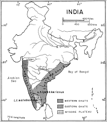
Table of Contents
How Western Ghat Emerged?
The origin of the Western Ghats dates back to around 150 million years ago, during the breakup of the supercontinent Gondwana. At that time, India was a part of Gondwana and was located near the South Pole. Over time, India started drifting northward, and around 50 million years ago, it collided with the Eurasian Plate.
The collision caused intense tectonic activity, leading to the formation of the Himalayan Mountains in the north and the Western Ghats in the south. The Western Ghats are primarily composed of ancient rocks, such as gneiss, schist, and granites, which were formed during the Archean Eon, around 3.5 billion years ago.
Over millions of years, the Western Ghats have undergone several geological processes, such as erosion, sedimentation, and volcanic activity. These processes have shaped the unique topography of the Western Ghats, characterized by rugged hills, plateaus, valleys, and waterfalls.
Today, the Western Ghats are recognized as one of the world’s eight hotspots of biodiversity, home to a diverse range of flora and fauna, including many endemic species. They are also an important source of water and play a crucial role in regulating the climate of the Indian subcontinent.
Spread of Western Ghat
The Western Ghats is a mountain range that stretches over a distance of about 1,600 km along the western coast of India. The range starts from the Tapti River in the north and runs southward through the states of Maharashtra, Goa, Karnataka, Tamil Nadu, and Kerala, before ending at Kanyakumari, the southernmost tip of India.
Rivers Originating in Western Ghat
Here are some of the major rivers that originate in the Western Ghats:
- Godavari River
- Krishna River
- Cauvery River
- Tungabhadra River
- Periyar River
- Sharavathi River
- Mandovi River
These rivers provide water for drinking, irrigation, and industrial purposes and support the diverse ecosystems of the Western Ghats.
Biodiversity of the Western Ghat
The Western Ghats are one of the world’s biodiversity hotspots, containing an estimated 7,402 species of flowering plants, 1814 species of non-flowering plants, 508 species of birds, 189 species of mammals, and 179 species of amphibians. The region also has a high level of endemism, with many species found only in the Western Ghats.
One of the most iconic species of the Western Ghats is the lion-tailed macaque, a critically endangered primate found only in the region. Other notable species include the Nilgiri Tahr, the Malabar giant squirrel, the Indian pangolin, and the black panther.
The Western Ghats are also home to a diverse range of ecosystems, including evergreen forests, semi-evergreen forests, deciduous forests, grasslands, and wetlands. These different ecosystems support a range of species and provide important ecosystem services, such as carbon storage, water regulation, and soil formation.
Conservation Efforts in the Western Ghats
The rich biodiversity of the Western Ghats is under threat from a range of human activities, including deforestation, mining, and agriculture. In recent years, there has been a growing recognition of the importance of conserving the region’s unique ecosystems and species.
The Indian government has taken a number of steps to protect the Western Ghats. In 2012, the Western Ghats were declared a UNESCO World Heritage Site, recognizing their outstanding universal value. The Indian government has also established numerous protected areas in the region, including national parks, wildlife sanctuaries, and biosphere reserves.
Important National Parks in Western Ghat
The Western Ghats are home to several important national parks and wildlife reserves that are crucial for the conservation of the region’s rich biodiversity. Here are some of the major national parks in the Western Ghats:
- Silent Valley National Park, Kerala: Located in the Nilgiri Hills of Kerala, this national park is known for its rich biodiversity and unique tropical rainforest ecosystem. It is home to several endangered species such as the Lion-tailed Macaque and the Nilgiri Langur.
- Periyar National Park, Kerala: Spread over an area of 925 sq km in the Cardamom Hills of Kerala, this national park is known for its tiger and elephant populations. The park also has a large reservoir, which is an important source of water for the surrounding areas.
- Bandipur National Park, Karnataka: Located in the Western Ghats of Karnataka, this national park is known for its diverse wildlife, including tigers, elephants, and Indian gaurs. The park is also home to several bird species and is a popular destination for birdwatchers.
- Nagarhole National Park, Karnataka: Another important national park in the Western Ghats of Karnataka, Nagarhole is known for its tiger and elephant populations, as well as for its scenic beauty and diverse birdlife.
- Mudumalai National Park, Tamil Nadu: Situated in the Nilgiri Hills of Tamil Nadu, Mudumalai is known for its diverse flora and fauna, including tigers, elephants, and Indian gaurs. The park is also home to several bird species and is a popular destination for wildlife enthusiasts.
Committees for the Conservation the Western Ghat
The Government of India has set up several committees to protect and conserve the Western Ghats, which is recognized as one of the biodiversity hotspots of the world. One such committee is the Western Ghats Ecology Expert Panel (WGEEP), which was set up in 2010 by the Ministry of Environment and Forests, Government of India.
The WGEEP was headed by Dr. Madhav Gadgil, a well-known ecologist and environmentalist, and comprised of experts from various fields such as ecology, wildlife biology, anthropology, and social sciences. The panel was tasked with preparing a report on the conservation and management of the Western Ghats, which was submitted to the government in 2011.
The WGEEP report recommended the establishment of a Western Ghats Ecology Authority (WGEA) to oversee the conservation and sustainable development of the region. The WGEA was proposed as a statutory body under the Ministry of Environment and Forests, with the power to regulate development activities in the ecologically sensitive areas of the Western Ghats.
However, the WGEEP report was met with resistance from some sections of society, particularly from the state governments of Kerala, Karnataka, and Maharashtra, who argued that the recommendations would adversely affect their developmental activities.
In response to the concerns raised by the states, the Government of India set up another committee in 2012, the High-Level Working Group (HLWG) headed by Dr. K. Kasturirangan, to review the WGEEP report and propose a more balanced approach to the conservation and development of the Western Ghats. The HLWG submitted its report in 2013, which proposed a zonal approach to the conservation and management of the Western Ghats, with different levels of protection for different areas based on their ecological sensitivity.
Comparison of the two Committees
| Parameter | Western Ghats Ecology Expert Panel (WGEEP) | High-Level Working Group (HLWG) |
|---|---|---|
| Year of Formation | 2010 | 2012 |
| Chairperson | Dr. Madhav Gadgil | Dr. K. Kasturirangan |
| Objective | Prepare a report on the conservation and management of the Western Ghats | Review the WGEEP report and propose a more balanced approach to the conservation and development of the Western Ghats |
| Recommendations | Establishment of a Western Ghats Ecology Authority (WGEA) to oversee the conservation and sustainable development of the region | Proposed a zonal approach to the conservation and management of the Western Ghats, with different levels of protection for different areas based on their ecological sensitivity |
| Criticism | Resistance from some state governments who argued that the recommendations would adversely affect their developmental activities | Some environmentalists and civil society groups criticized the report for diluting the WGEEP recommendations and giving too much leeway for development activities |
| Impact | Raised awareness about the ecological significance of the Western Ghats and formulated strategies to balance conservation and development | Helped to develop a more nuanced approach to the conservation and development of the Western Ghats, with greater emphasis on community participation and stakeholder consultation |
Rain Shadow Region of Western Ghat
The Western Ghats play a crucial role in shaping the climate and weather patterns of the surrounding regions. One important phenomenon associated with the Western Ghats is the formation of a rain shadow region on the eastern side of the mountain range.
When the moisture-laden winds from the Arabian Sea hit the Western Ghats, they are forced to rise and cool down, which causes the water vapor to condense and form clouds. As the clouds move over the Western Ghats and descend on the eastern side of the range, they have already released much of their moisture in the form of rain, leaving the eastern side of the range relatively dry.
This dry region on the eastern side of the Western Ghats is known as the rain shadow region. The rain shadow region covers parts of the states of Karnataka, Andhra Pradesh, and Tamil Nadu and is characterized by low rainfall and high temperatures. The region is home to several dry-land agricultural practices, including cultivation of crops such as millets, pulses, and oilseeds.
The Western Ghats not only influence the weather patterns of the surrounding regions but also have a significant impact on the ecology and biodiversity of the area. The rain shadow region, for example, has a unique set of flora and fauna that have adapted to the arid conditions of the region.
Highest Peak inn western Ghat
Anamudi, also known as Anai Mudi, is a mountain peak that rises to an elevation of 2,695 meters (8,842 feet) above sea level. The peak is located in the southern part of the Western Ghats, within the Eravikulam National Park in the district of Idukki in Kerala.
Apart from Anamudi, the Western Ghats is home to several other peaks that rise to impressive heights, including Doddabetta in Tamil Nadu, which rises to an elevation of 2,637 meters (8,652 feet), and Mullayanagiri in Karnataka, which rises to an elevation of 1,930 meters (6,330 feet).
Passes in Western Ghat
The Western Ghats mountain range is home to several passes that connect the coastal regions of India to the interior plateau. Some of the major passes in the Western Ghats are:
- Thal Ghat: Located in Maharashtra, this pass is one of the main routes connecting Mumbai to the interior regions of the state.
- Bhor Ghat: Also located in Maharashtra, this pass connects the city of Mumbai to the city of Pune and is an important transportation route for the region.
- Palakkad Gap: Located in the state of Kerala, this pass connects the coastal city of Kochi to the city of Coimbatore in Tamil Nadu.
- Agumbe Ghats: Located in Karnataka, these mountain passes connect the coastal town of Udupi to the interior regions of the state and are known for their scenic beauty.
- Talakaveri Pass: Located in the state of Karnataka, this pass is the source of the Kaveri River and is an important pilgrimage site for Hindus.
- Perambadi Pass: Located in Tamil Nadu, this pass connects the cities of Coimbatore and Ooty and is known for its scenic beauty and tea plantations.
These passes not only serve as transportation routes but also have a significant impact on the climate and ecology of the region. They provide important access to the Western Ghats and are an important part of the region’s cultural and historical heritage.
How passes were formed in Western Ghat?
The Western Ghats are a mountain range that runs along the western coast of India. The formation of passes in the Western Ghats can be attributed to a combination of tectonic and climatic factors.
Tectonically, the Western Ghats were formed due to the collision of the Indian Plate with the Eurasian Plate around 50 million years ago. The collision caused the formation of the mountain range, which runs roughly north-south along the western coast of India. Over time, the movement of the tectonic plates and the erosion caused by water, wind, and ice led to the formation of gaps or passes in the mountain range.
Climatically, the Western Ghats receive heavy rainfall during the monsoon season, which causes extensive erosion and the formation of gorges and valleys. These gorges and valleys eventually widen and deepen to form passes, which provide important routes through the mountain range for trade and transportation.
In addition to these natural factors, human activities such as road building and deforestation can also influence the formation and accessibility of passes in the Western Ghats.
Tribes of Western Ghat
The Western Ghats are home to a diverse range of indigenous tribes who have lived in the region for centuries, maintaining their unique cultural identities and traditional ways of life. Some of the major tribes inhabiting the Western Ghats include:
- Irula: The Irula tribe is one of the most prominent indigenous communities in the Western Ghats, mainly residing in the Nilgiri Hills and the Palani Hills of Tamil Nadu. They are known for their traditional knowledge of herbal medicine, agriculture, and animal husbandry.
- Toda: The Toda tribe is another indigenous community in the Nilgiri Hills of Tamil Nadu. They are known for their distinctive lifestyle, which includes unique architecture, dairy farming, and worship of the buffalo.
- Kurumba: The Kurumba tribe is mainly found in the Nilgiri Hills and the Wayanad district of Kerala. They have a rich cultural heritage, including traditional handicrafts, music, and dance.
- Kadar: The Kadar tribe inhabits the forests of the Western Ghats in Kerala and Tamil Nadu. They are skilled hunters and gatherers and have an intimate knowledge of the forest and its resources.
- Betta Kurumba: The Betta Kurumba tribe is one of the smaller indigenous communities in the Western Ghats, residing in the forests of the Nilgiri Hills. They are known for their unique language, handicrafts, and traditional hunting practices.
The Flower of Western Ghat that blooms once in 12 Years
The flower you are referring to is called the “Neelakurinji” (Strobilanthes kunthiana). It is a plant species that is endemic to the Western Ghats and is known for its unique blooming pattern.
Neelakurinji plants typically bloom once every 12 years, covering the hillsides of the Western Ghats in a beautiful purple-blue hue. The blooming of the Neelakurinji is an important event for the region’s ecology and is an important source of food for several species of animals.
The Neelakurinji is found in several areas of the Western Ghats, including the Nilgiri Hills in Tamil Nadu, the Anamalai Hills in Kerala, and the Biligiriranga Hills in Karnataka. The blooming of the Neelakurinji is a major attraction for tourists and draws visitors from all over the world to witness this unique natural phenomenon.
How Eastern Ghat Emerged?
The Eastern Ghats are a discontinuous range of mountains that run parallel to the eastern coast of India, stretching over a length of around 1,750 kilometers.
The formation of the Eastern Ghats is attributed to various geological processes that occurred over millions of years. During the Precambrian period, around 3.5 billion years ago, the Indian plate was part of the supercontinent called Rodinia.
Over time, the supercontinent broke up, and the Indian plate drifted towards the east, colliding with the Burmese microplate around 100 million years ago. The collision resulted in the upliftment of the Eastern Ghats, and the process of folding and faulting caused the rocks to deform and form mountain ranges.
The Eastern Ghats are composed of various types of rocks, such as granite, gneiss, schist, and limestone. The granite rocks, which are prevalent in the northern parts of the Eastern Ghats, were formed due to the cooling and solidification of molten magma. The sedimentary rocks, such as limestone and shale, were formed due to the deposition of sediments in the shallow seas that existed during the Cambrian and Ordovician periods.
Biodiversity of the Eastern Ghats
The Eastern Ghats are home to a rich diversity of flora and fauna. The region is particularly important for its endemic species, which are found only in the Eastern Ghats and not elsewhere in the world. The region has over 10,000 species of plants, including a high number of medicinal plants.
The Eastern Ghats are also home to a variety of wildlife, including several endangered species such as the Indian pangolin, the Bengal tiger, the Indian wild dog, and the Indian elephant. The region is also an important habitat for migratory birds, with several species visiting the area during the winter months.
The Eastern Ghats are also home to a number of unique ecosystems, including dry deciduous forests, scrublands, and grasslands. These ecosystems support a variety of species and provide important ecosystem services, such as carbon storage, water regulation, and soil formation.
Conservation Efforts in the Eastern Ghats
The Eastern Ghats are under threat from a range of human activities, including deforestation, mining, and agriculture. However, there are also several conservation efforts underway to protect the biodiversity of the region.
The Indian government has established several protected areas in the Eastern Ghats, including national parks, wildlife sanctuaries, and biosphere reserves. These protected areas provide important habitat for wildlife and help to safeguard the region’s unique ecosystems.
Comparing Key Characteristics of the Eastern Ghats and the Western Ghats
| Characteristics | Eastern Ghats | Western Ghats |
|---|---|---|
| Location | Along the eastern coast of India, from the Mahanadi River in the north to the Nilgiri Hills in the south | Along the western coast of India, running parallel to the Arabian Sea |
| Length | Approx. 1,750 km | Approx. 1,600 km |
| Area | Approx. 75,000 sq km | Approx. 140,000 sq km |
| Highest Peak | Jindhagada (1,690 m) | Anamudi (2,695 m) |
| Biodiversity | Rich diversity of flora and fauna, with over 10,000 species of plants and several endangered species such as the Indian pangolin, the Bengal tiger, the Indian wild dog, and the Indian elephant | High level of endemism, with over 5,000 species of flowering plants and several endangered species such as the Lion-tailed macaque, the Nilgiri tahr, and the Malabar grey hornbill |
| Climate | Tropical monsoon climate with high rainfall | Tropical monsoon climate with high rainfall |
| Importance | Home to several indigenous communities with unique cultural practices, as well as important mineral resources and unique ecosystems | Recognized as one of the world’s 8 “hottest hotspots” of biodiversity, with high levels of endemism and important ecosystem services such as carbon storage and water regulation |
| Conservation Efforts | Several protected areas established by the Indian government, as well as efforts by NGOs and community groups to promote sustainable development practices and protect endangered species | Several protected areas established by the Indian government, as well as efforts by NGOs and community groups to promote sustainable development practices and protect endangered species |
Where Western Ghat and Eastern Ghat meets
Summary
Western Ghats:
- Located along the western coast of India
- Runs parallel to the Arabian Sea
- Approx. 1,600 km in length
- Approx. 140,000 sq km in area
- Highest peak is Anamudi (2,695 m)
- Rich biodiversity, with high levels of endemism
- Home to several endangered species such as the Lion-tailed macaque and the Nilgiri tahr
- Tropical monsoon climate with high rainfall
- Recognized as one of the world’s 8 “hottest hotspots” of biodiversity
- Important for ecosystem services such as carbon storage and water regulation
- Conservation efforts include several protected areas and sustainable development practices
Eastern Ghats:
- Located along the eastern coast of India
- Runs from the Mahanadi River in the north to the Nilgiri Hills in the south
- Approx. 1,750 km in length
- Approx. 75,000 sq km in area
- Highest peak is Jindhagada (1,690 m)
- Rich biodiversity, with over 10,000 species of plants
- Home to several endangered species such as the Indian pangolin and the Indian elephant
- Tropical monsoon climate with high rainfall
- Important for mineral resources and unique ecosystems
- Conservation efforts include several protected areas and sustainable development practices
Meeting Point:
- Western Ghats and Eastern Ghats meet at the Nilgiri Hills
- Nilgiri Hills located in southern part of India
- Nilgiri Biosphere Reserve is a UNESCO World Heritage Site
- Biodiversity hotspot
- Home to several endemic species
- Provides important habitat for wildlife such as elephants, tigers, and Nilgiri langurs
- Important for agriculture and provides a livelihood for local communities
- Significant geographical and ecological landmark in India.
Questions
Q. Which of the following is the highest peak of the Western Ghats?
a. Arma Konda
b. Anamudi
c. Mount Everest
d. Kanchenjunga
Answer: b. Anamudi. Anamudi is the highest peak of the Western Ghats, located in the Indian state of Kerala.
Q. Which of the following is a UNESCO World Heritage Site?
a. Western Ghats
b. Eastern Ghats
c. Both a and b
d. None of the above
Answer: a. Western Ghats. The Western Ghats is recognized as a UNESCO World Heritage Site for its rich biodiversity and ecosystem services.
Q. Which of the following species is an endangered species found in the Western Ghats?
a. Indian pangolin
b. Lion-tailed macaque
c. Bengal tiger
d. Indian wild dog
Answer: b. Lion-tailed macaque. The Lion-tailed macaque is an endangered species found in the Western Ghats, known for its distinctive appearance and habitat loss.
Q. Which of the following species is an endangered species found in the Eastern Ghats?
a. Indian pangolin
b. Lion-tailed macaque
c. Bengal tiger
d. Indian wild dog
Answer: a. Indian pangolin. The Indian pangolin is an endangered species found in the Eastern Ghats, known for its role in pest control and illegal hunting for its meat and scales.
Q. Which of the following is a major threat to the Eastern Ghats?
a. Habitat loss
b. Climate change
c. Overfishing
d. None of the above
Answer: a. Habitat loss. Habitat loss due to deforestation, mining, and development is a major threat to the Eastern Ghats and its biodiversity.